اكتشف أين تغوص، ومتى تذهب، وما الذي يمكن أن تراه.

اكتشف أين تغوص، ومتى تذهب، وما الذي يمكن أن تراه.
★
القائمة
الوجهات مواقع الغوص الحياة البحرية حطام السفن الأخبار
خطّط لرحلة مخطّط الرحلات أفضل أوقات الغوص حاسبة التكاليف مقارنات تقويم الحياة البحرية درجة حرارة الماء الليفبوردات المشغّلون والمنتجعات المحميات البحرية غرف الضغط العالي خريطة العالم
الغوص في الكهوف جميع غطسات الكهوف الوجهات ومواقع الغوص أنظمة الكهوف والخرائط التدريب والمؤهلات مراكز الغوص والمرشدون المعدات والتكنولوجيا أبحاث السلامة والحوادث العلوم والتاريخ والحفاظ على البيئة الموارد والتحديثات
المناطق أستراليا، نيوزيلندا وشرق آسياالبحر الكاريبي وغرب المحيط الأطلسيأوروبا والأطلسي والمتوسطالمحيط الهندي وشرق أفريقياجزر المحيط الهادئ وميكرونيزياالبحر الأحمر والشرق الأوسطجنوب شرق آسيا ومثلث الشعاب المرجانيةالأمريكتان والمحيط الهادئ الشرقي الدول
التعلّم والأدوات جميع الأدلة الشهادات أدلة المعدات مقاطع فيديو استفسر عن البيانات وكلاء الذكاء الاصطناعي API
حول من نحن المنهجية إخلاء المسؤولية تواصل معنا
عرضك
★ محفوظ

وجهاتك وموقعك ومواقع الأنواع المحفوظة بالنجوم، مخزّنة في هذا المتصفح.

API GATEWAY

وصول JSON مجاني للقراءة فقط إلى البيانات المخزّنة في الأطلس.

الوضع الداكن

عرض المرشد
جديد على الغطس؟ الأعماق والتيارات ومستويات الشهادات؟ نشرح كل مصطلح أثناء تصفّحك بلغة واضحة. نفس البيانات، مع الشرح مدمجاً.

عرض الخبراء
أنت تعرف أصلًا الفرق بين الجدار وال drift dive. إليك البيانات فقط: واضحة وسريعة ومختصرة. هذا هو العرض الافتراضي.

لغة الواجهة

حفرة انهيارية

Big Dismal Sink

حفرة انهياريةWakulla-Leon Sinks cave systemUnited States
وصول مقيّد · كما هو منشور 2026-10-14 On national forest land managed by the USDA Forest Service; swimming prohibited, and diving access restricted since the area's designation in 1987 (per WKPP). قواعد الوصول تتغير: تأكد مع مالك الأرض أو الجهة المشرفة قبل سفرك.
موثَّق يُعرف أيضًا باسم: Big Dismal, Leon Sinks
عمق المدخل
غير منشور
المناطق الأكثر غوصاً
غير منشور
أقصى عمق هنا
غير منشور
الفئة المنشورة
لم يُنشر أي شيء

A large sinkhole in the Leon Sinks Geological Area of the Apalachicola National Forest and part of the Wakulla-Leon Sinks cave system; swimming is prohibited and recreational diving access has been restricted since 1987.

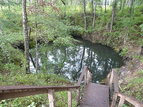
Big Dismal Sink lies along the trails of the Leon Sinks Geological Area, a Forest Service site south of Tallahassee where visitors walk past wet sinkholes, a natural bridge and a disappearing stream. Underwater, the sink is part of the Leon Sinks cave network: in June 1996 WKPP divers connected it to Cheryl Sink, and in 2007 the Leon Sinks caves were proven to connect with Wakulla Spring.

According to WKPP's history, diving access was restricted after Big Dismal, Little Dismal and nearby sinks were included in the Leon Sinks Geological Area in 1987. The Forest Service prohibits swimming in the area to protect the sinkhole walls and for visitor safety. Visitors can view the sinks from the trail system.

البيئة

A large sinkhole in the Woodville Karst Plain connecting to deep cave passages; no published dive measurements.

المرافق

Trail system (Sinkhole Trail 3.6 miles, Gum Swamp Trail 2.8 miles); restrooms listed by the Forest Service.

مداخل أخرى إلى Wakulla-Leon Sinks cave system
المصادر: [1] USDA Forest Service, National Forests in Florida ↗[2] Woodville Karst Plain Project ↗[3] Woodville Karst Plain Project ↗[4] Global Underwater Explorers ↗ · تم التحقق 2026-10-14
كل حقيقة في هذه الصفحة مع مصدرها (8)
حقيقةالحالةالمصدر
Swimming is not allowed in the Leon Sinks Geological Area, for the preservation of the sinkhole walls and personal safety.The Forest Service page does not mention diving. موثق [1]
In 1987 Big Dismal, Little Dismal and nearby sinks became part of the Leon Sinks Geological Area, which restricted diving access.From WKPP's history page; the current Forest Service diving policy was not found. تم الإبلاغ [2]
On 1996-06-01 WKPP divers connected Big Dismal Sink to upstream Cheryl Sink. موثق [3]
In December 2007 the Leon Sinks and Wakulla Springs caves were shown to be one system by a traverse from Turner Sink to Wakulla Spring. موثق [4]
The Forest Service charges $5 per vehicle and accepts America the Beautiful and Every Kid Outdoors passes.Read 2026-10-14. موثق [1]
Hours are 8 a.m. to 8 p.m. from April 1 to September 30 and 8 a.m. to 6 p.m. from October 1 to March 31.The page warns the site may close without notice for construction or safety. موثق [1]
The Sinkhole Trail is 3.6 miles and the Gum Swamp Trail 2.8 miles. موثق [1]
Swimming is not allowed in the Leon Sinks Geological Area; the Forest Service page publishes no diving information. موثق [1]

موثق: مُصرَّح به من مصدر رسمي أو أولي فتحناه. مُبلَّغ عنه: من مصدر ثانوي فقط. المصادر متضاربة: تتضمن الملاحظة النسختين. قد يكون قديماً: أحدث مصدر وجدناه قديم.

مكتوب بأسلوبنا الخاص من المصادر أعلاه. الإبلاغ عن تصحيح

أستراليا، نيوزيلندا وشرق آسيا

Cairns & the Ribbon ReefsNingaloo ReefCoral Sea & Osprey ReefOkinawa & the Kerama IslandsPoor Knights IslandsTownsville & the YongalaGreen IslandIzu Peninsula

البحر الكاريبي وغرب المحيط الأطلسي

BonaireCozumelRiviera Maya & the CenotesBelize Barrier ReefGrand CaymanIsla Mujeres & CancúnRoatánTiger Beach & Grand Bahama

أوروبا والأطلسي والمتوسط

Malta & GozoSilfra & IcelandThe AzoresCanary IslandsLarnaca & the ZenobiaScapa FlowArctic NorwayMadeira

المحيط الهندي وشرق أفريقيا

North & South Malé AtollsAri AtollBaa Atoll & Hanifaru BayAliwal Shoal & UmkomaasMafia IslandMauritiusSeychellesSodwana Bay

جزر المحيط الهادئ وميكرونيزيا

PalauChuuk (Truk) LagoonFakaravaKona, HawaiʻiRangiroaTaveuni & Rainbow ReefBeqa Lagoon & Pacific HarbourEspiritu Santo

البحر الأحمر والشرق الأوسط

Sharm El Sheikh & Ras MohammedBrothers, Daedalus & St John'sDahabHurghada & El GounaMarsa Alam & the Deep SouthAqabaDaymaniyat IslandsMusandam Peninsula

جنوب شرق آسيا ومثلث الشعاب المرجانية

Bali & Nusa PenidaKomodoRaja AmpatSipadan & MabulAnilaoCoronKoh TaoLembeh Strait

الأمريكتان والمحيط الهادئ الشرقي

Galápagos IslandsCocos IslandFlorida KeysSea of Cortez & Cabo PulmoSocorro & the RevillagigedosBritish ColumbiaCalifornia Channel IslandsCosta Rica Pacific Coast