Descubre dónde bucear, cuándo ir y qué podrías ver.

Descubre dónde bucear, cuándo ir y qué podrías ver.
★
Menú
Destinos Puntos de buceo Vida marina Pecios Noticias
Planifica un viaje Planificador de viajes Cuándo bucear Calculadora de costes Comparativas Calendario de fauna marina Temperatura del agua Liveaboards Operadores y resorts Parques marinos Cámaras hiperbáricas Mapa mundial
Buceo en cuevas Todo sobre el buceo en cueva Destinos y sitios de buceo Sistemas de Cuevas y Mapas Formación y titulaciones Centros de buceo y guías Equipamiento y tecnología Seguridad e investigación de incidentes Ciencia, historia y conservación Recursos y actualizaciones
Regiones Australia, Nueva Zelanda y Asia OrientalCaribe y Atlántico occidentalEuropa, Atlántico y MediterráneoOcéano Índico y África OrientalIslas del Pacífico y MicronesiaMar Rojo y Oriente MedioSudeste Asiático y el Triángulo del CoralLas Américas y el Pacífico Oriental Países
Aprender y herramientas Todas las guías Certificaciones Guías de equipo Vídeos Consulta los datos Agentes de IA API
Acerca de Quiénes somos Metodología Aviso legal Contacto
Tu vista
★ Guardado

Tus destinos, puntos de buceo y especies marcados como favoritos, guardados en este navegador.

API GATEWAY

Acceso JSON gratuito de solo lectura a los datos en caché del atlas.

Modo oscuro

Vista guiada
¿Nuevo en el buceo? ¿Profundidades, corrientes, niveles de certificación? Explicamos cada término mientras navegas, en un lenguaje claro. Los mismos datos, con la ayuda integrada.

Vista experta
Ya conoces la diferencia entre una pared y un drift dive. Solo los datos: claros, rápidos y concisos. Esta es la vista predeterminada.

Idioma de la interfaz

Sumidero

Big Dismal Sink

SumideroWakulla-Leon Sinks cave systemUnited States
Acceso restringido · tal como está publicado 2026-10-14 On national forest land managed by the USDA Forest Service; swimming prohibited, and diving access restricted since the area's designation in 1987 (per WKPP). Las normas de acceso cambian: confírmalo con el propietario del terreno o la autoridad gestora antes de viajar.
Documentado También conocido como: Big Dismal, Leon Sinks
Profundidad de la entrada
No publicado
Zonas de buceo habituales
No publicado
Profundidad máxima aquí
No publicado
Categoría publicada
Ninguno publicado

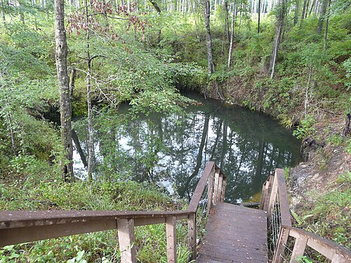
A large sinkhole in the Leon Sinks Geological Area of the Apalachicola National Forest and part of the Wakulla-Leon Sinks cave system; swimming is prohibited and recreational diving access has been restricted since 1987.

Big Dismal Sink lies along the trails of the Leon Sinks Geological Area, a Forest Service site south of Tallahassee where visitors walk past wet sinkholes, a natural bridge and a disappearing stream. Underwater, the sink is part of the Leon Sinks cave network: in June 1996 WKPP divers connected it to Cheryl Sink, and in 2007 the Leon Sinks caves were proven to connect with Wakulla Spring.

According to WKPP's history, diving access was restricted after Big Dismal, Little Dismal and nearby sinks were included in the Leon Sinks Geological Area in 1987. The Forest Service prohibits swimming in the area to protect the sinkhole walls and for visitor safety. Visitors can view the sinks from the trail system.

El entorno

A large sinkhole in the Woodville Karst Plain connecting to deep cave passages; no published dive measurements.

Instalaciones

Trail system (Sinkhole Trail 3.6 miles, Gum Swamp Trail 2.8 miles); restrooms listed by the Forest Service.

Otras entradas a Wakulla-Leon Sinks cave system
Fuentes: [1] USDA Forest Service, National Forests in Florida ↗[2] Woodville Karst Plain Project ↗[3] Woodville Karst Plain Project ↗[4] Global Underwater Explorers ↗ · comprobado 2026-10-14
Cada dato de esta página, con su fuente (8)
DatoEstadoFuente
Swimming is not allowed in the Leon Sinks Geological Area, for the preservation of the sinkhole walls and personal safety.The Forest Service page does not mention diving. Verificado [1]
In 1987 Big Dismal, Little Dismal and nearby sinks became part of the Leon Sinks Geological Area, which restricted diving access.From WKPP's history page; the current Forest Service diving policy was not found. Reportado [2]
On 1996-06-01 WKPP divers connected Big Dismal Sink to upstream Cheryl Sink. Verificado [3]
In December 2007 the Leon Sinks and Wakulla Springs caves were shown to be one system by a traverse from Turner Sink to Wakulla Spring. Verificado [4]
The Forest Service charges $5 per vehicle and accepts America the Beautiful and Every Kid Outdoors passes.Read 2026-10-14. Verificado [1]
Hours are 8 a.m. to 8 p.m. from April 1 to September 30 and 8 a.m. to 6 p.m. from October 1 to March 31.The page warns the site may close without notice for construction or safety. Verificado [1]
The Sinkhole Trail is 3.6 miles and the Gum Swamp Trail 2.8 miles. Verificado [1]
Swimming is not allowed in the Leon Sinks Geological Area; the Forest Service page publishes no diving information. Verificado [1]

Verificado: declarado por una fuente oficial o primaria que consultamos directamente. Reportado: basado únicamente en una fuente secundaria. Fuentes en conflicto: la nota recoge ambas versiones. Puede estar desactualizado: la fuente más reciente que encontramos es antigua.

Redactado con nuestras propias palabras a partir de las fuentes anteriores. Reportar una corrección

Australia, Nueva Zelanda y Asia Oriental

Cairns & the Ribbon ReefsNingaloo ReefCoral Sea & Osprey ReefOkinawa & the Kerama IslandsPoor Knights IslandsTownsville & the YongalaGreen IslandIzu Peninsula

Caribe y Atlántico occidental

BonaireCozumelRiviera Maya & the CenotesBelize Barrier ReefGrand CaymanIsla Mujeres & CancúnRoatánTiger Beach & Grand Bahama

Europa, Atlántico y Mediterráneo

Malta & GozoSilfra & IcelandThe AzoresCanary IslandsLarnaca & the ZenobiaScapa FlowArctic NorwayMadeira

Océano Índico y África Oriental

North & South Malé AtollsAri AtollBaa Atoll & Hanifaru BayAliwal Shoal & UmkomaasMafia IslandMauritiusSeychellesSodwana Bay

Islas del Pacífico y Micronesia

PalauChuuk (Truk) LagoonFakaravaKona, HawaiʻiRangiroaTaveuni & Rainbow ReefBeqa Lagoon & Pacific HarbourEspiritu Santo

Mar Rojo y Oriente Medio

Sharm El Sheikh & Ras MohammedBrothers, Daedalus & St John'sDahabHurghada & El GounaMarsa Alam & the Deep SouthAqabaDaymaniyat IslandsMusandam Peninsula

Sudeste Asiático y el Triángulo del Coral

Bali & Nusa PenidaKomodoRaja AmpatSipadan & MabulAnilaoCoronKoh TaoLembeh Strait

Las Américas y el Pacífico Oriental

Galápagos IslandsCocos IslandFlorida KeysSea of Cortez & Cabo PulmoSocorro & the RevillagigedosBritish ColumbiaCalifornia Channel IslandsCosta Rica Pacific Coast