केव एंट्रेंस
Gouffre de Pou Meyssen
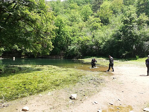
A small pool at the foot of a cliff in a dry valley above Cabouy that gives a second way into the flooded Ouysse river, about 800 m upstream of Cabouy underground.
Pou Meyssen lies at the foot of a cliff in a rock recess behind a thicket of dogwood, about 1 km up the dry valley from Cabouy on foot or by a stony track off the Rocamadour–Couzou road. The pool is about 6 m long and 2.5 m wide and its level varies with the seasons.
Below the pool a chamber of boulders lies at about 10 m. Downstream the gallery averages 14 to 20 m deep towards Cabouy; upstream it rises to about 9 m before levelling between 14 and 16 m. The Subaqua account of the 2011-2014 re-lining says the small pool clouds up immediately when divers enter, so the team fixed a rope from the surface to a T-junction with the main line, signed for the Pou Meyssen exit and for Cabouy 800 m away.
पर्यावरण
A narrow, easily silted entrance pool leading into the large underground Ouysse river passage.
परिस्थितियाँ
Visibility at the entrance is frequently lost as soon as divers enter the small pool; water level varies seasonally.
प्रकाशित स्रोतों से सामान्य अनुमानित दायरे, वर्तमान परिस्थितियाँ नहीं।
इसके अन्य entrance Réseau de l'Ouysse (Cabouy – Pou Meyssen)
अभिमुखीकरण के लिए, navigation के लिए नहीं। खोखले बिंदु अनुमानित हैं।
इस पृष्ठ का हर तथ्य, अपने source के साथ (8)
| तथ्य | स्थिति | स्रोत |
|---|---|---|
| The entrance pool is about 6 m long and 2.5 m wide and its level varies with the seasons. | सत्यापित | [1] |
| A boulder chamber lies at about -10 m; the downstream gallery averages -14 to -20 m and the upstream gallery stabilises between -14 and -16 m. | सत्यापित | [1] |
| The small pool clouds up immediately and the sediment raised on entry often wipes out visibility. | सत्यापित | [2] |
| A rope fixed above the pool joins the main line at a T marked 'Sortie/Exit Pou Meyssen' and 'Cabouy 800 m'.Installed during 2011-2014 re-lining; present condition not verified. | सत्यापित | [2] |
| The fiche gives directions but no access rules. | रिपोर्ट किया गया | [1] |
| Area-level position near N 44.79 E 1.59, derived from the FFS fiche (N 44°47'27" E 1°35'34"). | सत्यापित | [1] |
| Area-level position near N 44.79 E 1.59. | सत्यापित | [1] |
| The sources consulted publish no qualification, permit or registration requirement set by a land manager or access body for this site.Absence of a published rule, not confirmation that none exists. | रिपोर्ट किया गया | [1] |
सत्यापित: किसी आधिकारिक या प्राथमिक स्रोत से पुष्टि हुई जिसे हमने खोला। रिपोर्ट किया गया: केवल द्वितीयक स्रोत से। स्रोतों में मतभेद: नोट में दोनों संस्करण दिए गए हैं। पुराना हो सकता है: हमें मिला सबसे नया स्रोत भी पुराना है।
ऊपर दिए गए sources से हमारे अपने शब्दों में लिखा गया। सुधार की रिपोर्ट करें