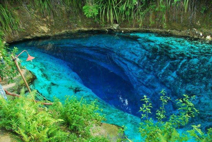
Enchanted River (Hinatuan)
A popular spring-fed swimming spot in Mindanao whose pool hides an underwater cave entrance at about 30 m. Tidal flow and a halocline change cave conditions sharply; no dive access procedure is published.
The spring pool at the head of the Enchanted River is a busy public attraction managed by the Hinatuan municipality as an eco-tourism area. The cave entrance lies about 30 m down in the pool.
Filipino Cave Divers reports describe seawater entering on high tides, a halocline around 33 m, and a cave that cannot be entered near its peak outflow. The same reports note a partial ceiling collapse found in 2013 and concern that heavy visitor numbers may harm a fragile ecosystem.
環境
Spring pool over an underwater cave; brackish to salt water can intrude with the tide, with a halocline recorded at 33 m.
コンディション
Conditions depend on the tide: FCD divers recorded inward current, seawater and very poor visibility above the halocline at high tide, and still, very clear water at another tide state.
公表資料からの一般的な範囲であり、現在のコンディションではありません。
方向確認用であり、ナビゲーション用ではありません。白抜きのドットはおおよその位置を示しています。
このページのすべての情報とその出典 (6)
| 情報 | ステータス | 出典 |
|---|---|---|
| The river starts from an underwater cave entrance at 30 m depth. | 報告済み | [1] |
| On a high-tide dive divers met seawater, an inward current and very poor visibility until a halocline at 33 m; on another dive there was no current and very clear water.Observations from August 2013. | 報告済み | [2] |
| The team found recent cave-in sites with loose limestone on the ceiling in August 2013. | 報告済み | [2] |
| The municipality owns 27 hectares around the river and has declared it an eco-tourism area.As of March 2015. | 報告済み | [1] |
| FCD gives the coordinates 8.458886 N, 126.354667 E.Public tourist site. | 報告済み | [1] |
| FCD gives the coordinates 8.458886 N, 126.354667 E.Public tourist site. | 報告済み | [1] |
確認済み:直接開いた公式または一次情報源による記載。報告ベース:二次情報源のみによるもの。情報が競合:注釈に両方のバージョンを記載。最新情報でない可能性あり:確認できた最新の情報源が古い。
上記のソースをもとに、独自の言葉でまとめています。 修正を報告する