发现去哪里潜水、何时出发,以及你可能看到什么。

发现去哪里潜水、何时出发,以及你可能看到什么。
★
菜单
目的地 潜点 海洋生物 沉船 资讯
规划一次旅行 行程规划 最佳潜水时机 费用计算器 对比 海洋生物日历 水温 船宿 运营商与度假村 海洋公园 高压氧舱 世界地图
洞穴潜水 全部洞穴潜水 目的地与潜点 洞穴系统与地图 训练与资质 潜水中心与向导 装备与技术 安全与事故研究 科学、历史与保护 资源与更新
地区 澳大利亚、新西兰与东亚加勒比海与西大西洋欧洲、大西洋与地中海印度洋与东非太平洋岛屿与密克罗尼西亚红海与中东东南亚与珊瑚三角区美洲与东太平洋 目的地国家
学习与工具 所有指南 潜水认证 装备指南 视频 数据问答 AI智能体 API
关于 关于我们 方法论 免责声明 联系
您的视图
★ 已收藏

您收藏的目的地、潜点和物种,均存储在本浏览器中。

API网关

免费只读JSON接口,访问图鉴缓存数据。

深色模式

引导视角
刚接触潜水?对深度、水流、认证等级有疑问?在浏览过程中,我们用简单易懂的语言解释每个术语。数据相同,帮助已内置其中。

专家视角
峭壁和漂流潜水的区别您已经清楚。这里只有数据,简洁、直接、紧凑,这是默认视图。

界面语言
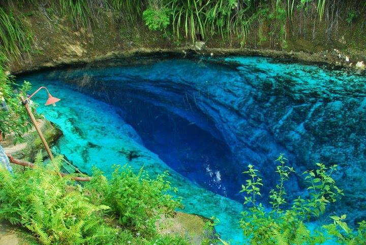
Enchanted River (Hinatuan) 照片: 2il org · CC BY 2.0
开放状态未经核实 · 依已发布信息 2015-03-14 Municipally managed eco-tourism site; no published procedure for cave diving was found. 出入规定可能随时变更,出发前请向土地所有者或主管机构确认。
已记录 又称: Hinatuan Enchanted River, Enchanted River, HERUCS
入口深度
30 m (98 ft)
常见潜水区域
未发布
此处最大深度
未发布
已发布的分类
未发布

A popular spring-fed swimming spot in Mindanao whose pool hides an underwater cave entrance at about 30 m. Tidal flow and a halocline change cave conditions sharply; no dive access procedure is published.

The spring pool at the head of the Enchanted River is a busy public attraction managed by the Hinatuan municipality as an eco-tourism area. The cave entrance lies about 30 m down in the pool.

Filipino Cave Divers reports describe seawater entering on high tides, a halocline around 33 m, and a cave that cannot be entered near its peak outflow. The same reports note a partial ceiling collapse found in 2013 and concern that heavy visitor numbers may harm a fragile ecosystem.

环境

Spring pool over an underwater cave; brackish to salt water can intrude with the tide, with a halocline recorded at 33 m.

环境条件

Conditions depend on the tide: FCD divers recorded inward current, seawater and very poor visibility above the halocline at high tide, and still, very clear water at another tide state.

典型范围来自已发表资料,不代表当前实际状况。

Enchanted River (Hinatuan) 卫星底图:NASA Blue Marble

仅供方位参考,不可用于导航。空心圆点为大致位置。

资料来源: [1] Filipino Cave Divers ↗[2] Filipino Cave Divers ↗ · 已核查 2026-10-14
本页所有信息及其来源 (6)
信息条目状态来源
The river starts from an underwater cave entrance at 30 m depth. 已报告 [1]
On a high-tide dive divers met seawater, an inward current and very poor visibility until a halocline at 33 m; on another dive there was no current and very clear water.Observations from August 2013. 已报告 [2]
The team found recent cave-in sites with loose limestone on the ceiling in August 2013. 已报告 [2]
The municipality owns 27 hectares around the river and has declared it an eco-tourism area.As of March 2015. 已报告 [1]
FCD gives the coordinates 8.458886 N, 126.354667 E.Public tourist site. 已报告 [1]

已核实:来自我们直接查阅的官方或主要来源。已报告:仅来自二手来源。来源存在冲突:注释中列出两种版本。可能已过时:我们找到的最新来源已有一定年代。

由我们根据上述来源以自己的文字整理撰写。 提交更正

澳大利亚、新西兰与东亚

Cairns & the Ribbon ReefsNingaloo ReefCoral Sea & Osprey ReefOkinawa & the Kerama IslandsPoor Knights IslandsTownsville & the YongalaGreen IslandIzu Peninsula

加勒比海与西大西洋

BonaireCozumelRiviera Maya & the CenotesBelize Barrier ReefGrand CaymanIsla Mujeres & CancúnRoatánTiger Beach & Grand Bahama

欧洲、大西洋与地中海

Malta & GozoSilfra & IcelandThe AzoresCanary IslandsLarnaca & the ZenobiaScapa FlowArctic NorwayMadeira

印度洋与东非

North & South Malé AtollsAri AtollBaa Atoll & Hanifaru BayAliwal Shoal & UmkomaasMafia IslandMauritiusSeychellesSodwana Bay

太平洋岛屿与密克罗尼西亚

PalauChuuk (Truk) LagoonFakaravaKona, HawaiʻiRangiroaTaveuni & Rainbow ReefBeqa Lagoon & Pacific HarbourEspiritu Santo

红海与中东

Sharm El Sheikh & Ras MohammedBrothers, Daedalus & St John'sDahabHurghada & El GounaMarsa Alam & the Deep SouthAqabaDaymaniyat IslandsMusandam Peninsula

东南亚与珊瑚三角区

Bali & Nusa PenidaKomodoRaja AmpatSipadan & MabulAnilaoCoronKoh TaoLembeh Strait

美洲与东太平洋

Galápagos IslandsCocos IslandFlorida KeysSea of Cortez & Cabo PulmoSocorro & the RevillagigedosBritish ColumbiaCalifornia Channel IslandsCosta Rica Pacific Coast