اكتشف أين تغوص، ومتى تذهب، وما الذي يمكن أن تراه.

اكتشف أين تغوص، ومتى تذهب، وما الذي يمكن أن تراه.
★
القائمة
الوجهات مواقع الغوص الحياة البحرية حطام السفن الأخبار
خطّط لرحلة مخطّط الرحلات أفضل أوقات الغوص حاسبة التكاليف مقارنات تقويم الحياة البحرية درجة حرارة الماء الليفبوردات المشغّلون والمنتجعات المحميات البحرية غرف الضغط العالي خريطة العالم
الغوص في الكهوف جميع غطسات الكهوف الوجهات ومواقع الغوص أنظمة الكهوف والخرائط التدريب والمؤهلات مراكز الغوص والمرشدون المعدات والتكنولوجيا أبحاث السلامة والحوادث العلوم والتاريخ والحفاظ على البيئة الموارد والتحديثات
المناطق أستراليا، نيوزيلندا وشرق آسياالبحر الكاريبي وغرب المحيط الأطلسيأوروبا والأطلسي والمتوسطالمحيط الهندي وشرق أفريقياجزر المحيط الهادئ وميكرونيزياالبحر الأحمر والشرق الأوسطجنوب شرق آسيا ومثلث الشعاب المرجانيةالأمريكتان والمحيط الهادئ الشرقي الدول
التعلّم والأدوات جميع الأدلة الشهادات أدلة المعدات مقاطع فيديو استفسر عن البيانات وكلاء الذكاء الاصطناعي API
حول من نحن المنهجية إخلاء المسؤولية تواصل معنا
عرضك
★ محفوظ

وجهاتك وموقعك ومواقع الأنواع المحفوظة بالنجوم، مخزّنة في هذا المتصفح.

API GATEWAY

وصول JSON مجاني للقراءة فقط إلى البيانات المخزّنة في الأطلس.

الوضع الداكن

عرض المرشد
جديد على الغطس؟ الأعماق والتيارات ومستويات الشهادات؟ نشرح كل مصطلح أثناء تصفّحك بلغة واضحة. نفس البيانات، مع الشرح مدمجاً.

عرض الخبراء
أنت تعرف أصلًا الفرق بين الجدار وال drift dive. إليك البيانات فقط: واضحة وسريعة ومختصرة. هذا هو العرض الافتراضي.

لغة الواجهة
Lake Otjikoto

Lake Otjikoto

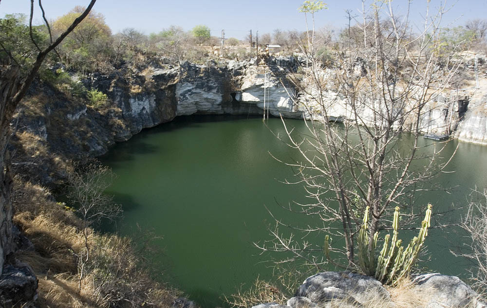
حفرة انهياريةLake OtjikotoNamibia
الصورة: Greg Willis · CC BY-SA 2.5
وصول مقيّد · كما هو منشور 2017-10-24 Public heritage site administered by the National Heritage Council of Namibia (2017) with a viewing fee and daily hours; diving limited to organised, authorised groups. Current diving procedure not published. قواعد الوصول تتغير: تأكد مع مالك الأرض أو الجهة المشرفة قبل سفرك.
موثَّق يُعرف أيضًا باسم: Otjikoto Lake, Otjikoto, Gaisis
عمق المدخل
غير منشور
المناطق الأكثر غوصاً
55 m (180 ft)
أقصى عمق هنا
غير منشور
الفئة المنشورة
Type III
درجة حرارة الماء
18–22 °C

Type III: CMAS sinkhole type (as reported in 2009) [1] (Classification reported in a 2009 newspaper article; no current CMAS document was found to confirm it.). هذه الفئات مأخوذة من المخطط المُسمَّى ذاته؛ وتصف مستوى التدريب الذي يتطلبه الموقع.

A heritage sinkhole lake near Tsumeb whose 'underwater museum' of 1915 weapons lies at about 41-55 m. Diving has been limited to organised and authorised groups.

Divers enter Lake Otjikoto from its shore; in 2009 an entry ladder reached down to 6 m. Below, named features step down the wall from about 28 m, and the dumped weapons lie at roughly 45-55 m. One 2025 report says divers need to be qualified to at least 50 m to explore them.

The lake is a public heritage site where visitors pay to view it from the rim, but diving is not open to casual visitors. Earlier reports describe dives run through the Namibian Underwater Federation and authorised operators, and training use by police divers. Current diving arrangements should be confirmed with the National Heritage Council of Namibia.

البيئة

Still, fresh water in a steep-sided sinkhole, about 22 C near the surface and 18 C lower down in 2009, with visibility up to about 15 m. Narrow caves lead off at depth.

الظروف

Temperature and visibility from 2009; the water level rose sharply after the 2025 rains.

نطاقات اعتيادية من مصادر منشورة، لا ظروف آنية.

Lake OtjikotoLake Guinas صور الأقمار الاصطناعية: NASA Blue Marble

للتوجه العام، لا للملاحة. النقاط المفرغة تحديد تقريبي.

المصادر: [1] Allgemeine Zeitung (Namibia) ↗[2] Namibian.org (text credited to Dirk Heinrich) ↗[3] The Namibian ↗[4] Wikipedia ↗ · تم التحقق 2026-10-14
كل حقيقة في هذه الصفحة مع مصدرها (8)
حقيقةالحالةالمصدر
The dumped weapons and other features lie at about 28-55 m, including the armaments at 45-55 m. تم الإبلاغ [1] [2]
In 2009 the entry ladder reached 6 m. قد تكون قديمة [1]
About 22 C near the surface and 18 C deeper, visibility up to 15 m (2009). قد تكون قديمة [1]
Divers must be qualified to 50 m or deeper to explore the underwater museum. تم الإبلاغ [2]
In 2009 Lake Otjikoto was described as a Type III sinkhole under the CMAS classification. قد تكون قديمة [1]
Administered by the National Heritage Council of Namibia in 2017, with a viewing fee; diving limited to organised and authorised groups. قد تكون قديمة [3] [1]
In 2017 the site was open 08:00-17:00, Monday to Sunday.2017 newspaper report; re-check before use. قد تكون قديمة [3]
Area-level coordinates for a public heritage site beside the B1 road. تم الإبلاغ [4] [2]

موثق: مُصرَّح به من مصدر رسمي أو أولي فتحناه. مُبلَّغ عنه: من مصدر ثانوي فقط. المصادر متضاربة: تتضمن الملاحظة النسختين. قد يكون قديماً: أحدث مصدر وجدناه قديم.

مكتوب بأسلوبنا الخاص من المصادر أعلاه. الإبلاغ عن تصحيح

أستراليا، نيوزيلندا وشرق آسيا

Cairns & the Ribbon ReefsNingaloo ReefCoral Sea & Osprey ReefOkinawa & the Kerama IslandsPoor Knights IslandsTownsville & the YongalaGreen IslandIzu Peninsula

البحر الكاريبي وغرب المحيط الأطلسي

BonaireCozumelRiviera Maya & the CenotesBelize Barrier ReefGrand CaymanIsla Mujeres & CancúnRoatánTiger Beach & Grand Bahama

أوروبا والأطلسي والمتوسط

Malta & GozoSilfra & IcelandThe AzoresCanary IslandsLarnaca & the ZenobiaScapa FlowArctic NorwayMadeira

المحيط الهندي وشرق أفريقيا

North & South Malé AtollsAri AtollBaa Atoll & Hanifaru BayAliwal Shoal & UmkomaasMafia IslandMauritiusSeychellesSodwana Bay

جزر المحيط الهادئ وميكرونيزيا

PalauChuuk (Truk) LagoonFakaravaKona, HawaiʻiRangiroaTaveuni & Rainbow ReefBeqa Lagoon & Pacific HarbourEspiritu Santo

البحر الأحمر والشرق الأوسط

Sharm El Sheikh & Ras MohammedBrothers, Daedalus & St John'sDahabHurghada & El GounaMarsa Alam & the Deep SouthAqabaDaymaniyat IslandsMusandam Peninsula

جنوب شرق آسيا ومثلث الشعاب المرجانية

Bali & Nusa PenidaKomodoRaja AmpatSipadan & MabulAnilaoCoronKoh TaoLembeh Strait

الأمريكتان والمحيط الهادئ الشرقي

Galápagos IslandsCocos IslandFlorida KeysSea of Cortez & Cabo PulmoSocorro & the RevillagigedosBritish ColumbiaCalifornia Channel IslandsCosta Rica Pacific Coast