जानिए कहाँ गोता लगाएँ, कब जाएँ और आप क्या देख सकते हैं।

जानिए कहाँ गोता लगाएँ, कब जाएँ और आप क्या देख सकते हैं।
★
मेनू
गंतव्य डाइव साइट समुद्री जीवन Wrecks समाचार
एक ट्रिप प्लान करें ट्रिप प्लानर डाइव कब करें लागत कैलकुलेटर तुलनाएँ मरीन-लाइफ कैलेंडर पानी का तापमान लाइवअबोर्ड ऑपरेटर और रिसॉर्ट समुद्री उद्यान हाइपरबेरिक चैंबर्स विश्व मानचित्र
गुफा डाइविंग सभी cave diving गंतव्य और डाइव साइटें केव सिस्टम और मैप्स ट्रेनिंग और योग्यताएँ डाइव सेंटर और गाइड उपकरण और तकनीक सुरक्षा और घटना शोध विज्ञान, इतिहास और संरक्षण संसाधन और अपडेट
क्षेत्र ऑस्ट्रेलिया, न्यूज़ीलैंड और पूर्वी एशियाकैरिबियन और पश्चिमी अटलांटिकयूरोप, अटलांटिक और भूमध्य सागरहिंद महासागर और पूर्वी अफ्रीकाप्रशांत द्वीप और माइक्रोनेशियालाल सागर और मध्य पूर्वदक्षिण-पूर्व एशिया और कोरल ट्राएंगलअमेरिका और पूर्वी प्रशांत देश
सीखें और टूल्स सभी गाइड सर्टिफ़िकेशन गियर गाइड्स वीडियो डेटा से पूछें AI एजेंट्स API
परिचय हमारे बारे में कार्यप्रणाली अस्वीकरण संपर्क
आपका व्यू
★ सहेजा गया

आपके starred गंतव्य, sites और प्रजातियाँ, इस browser में संग्रहीत।

API GATEWAY

एटलस के कैश्ड डेटा तक मुफ़्त रीड-ओनली JSON एक्सेस।

डार्क मोड

गाइडेड दृश्य
Diving में नए हैं? Depths, currents, certification levels? हम हर term को browse करते हुए plain भाषा में समझाते हैं। वही data, साथ में मदद।

विशेषज्ञ दृश्य
आप wall और drift dive का फ़र्क पहले से जानते हैं। बस डेटा: साफ़, तेज़ और संक्षिप्त। यह डिफ़ॉल्ट व्यू है।

इंटरफ़ेस भाषा
Lake Otjikoto

Lake Otjikoto

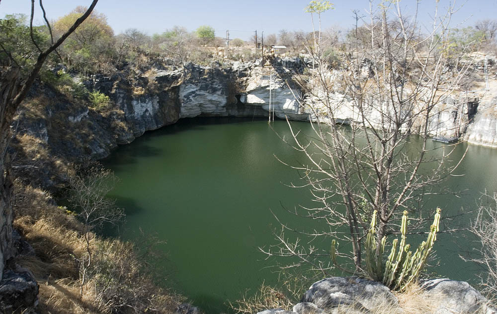
सिंकहोलLake OtjikotoNamibia
फ़ोटो: Greg Willis · CC BY-SA 2.5
प्रतिबंधित पहुँच · जैसा प्रकाशित है 2017-10-24 Public heritage site administered by the National Heritage Council of Namibia (2017) with a viewing fee and daily hours; diving limited to organised, authorised groups. Current diving procedure not published. Access के नियम बदलते रहते हैं: यात्रा से पहले भूस्वामी या प्रबंधन प्राधिकरण से पुष्टि करें।
प्रमाणित इन्हें भी जाना जाता है: Otjikoto Lake, Otjikoto, Gaisis
प्रवेश द्वार की गहराई
प्रकाशित नहीं
सामान्यतः dive किए जाने वाले क्षेत्र
55 m (180 ft)
यहाँ अधिकतम गहराई
प्रकाशित नहीं
प्रकाशित श्रेणी
Type III
पानी का तापमान
18–22 °C

Type III: CMAS sinkhole type (as reported in 2009) [1] (Classification reported in a 2009 newspaper article; no current CMAS document was found to confirm it.). ये श्रेणियाँ उस नामित योजना की अपनी हैं; ये बताती हैं कि किसी site के लिए किस प्रशिक्षण की ज़रूरत होती है।

A heritage sinkhole lake near Tsumeb whose 'underwater museum' of 1915 weapons lies at about 41-55 m. Diving has been limited to organised and authorised groups.

Divers enter Lake Otjikoto from its shore; in 2009 an entry ladder reached down to 6 m. Below, named features step down the wall from about 28 m, and the dumped weapons lie at roughly 45-55 m. One 2025 report says divers need to be qualified to at least 50 m to explore them.

The lake is a public heritage site where visitors pay to view it from the rim, but diving is not open to casual visitors. Earlier reports describe dives run through the Namibian Underwater Federation and authorised operators, and training use by police divers. Current diving arrangements should be confirmed with the National Heritage Council of Namibia.

पर्यावरण

Still, fresh water in a steep-sided sinkhole, about 22 C near the surface and 18 C lower down in 2009, with visibility up to about 15 m. Narrow caves lead off at depth.

परिस्थितियाँ

Temperature and visibility from 2009; the water level rose sharply after the 2025 rains.

प्रकाशित स्रोतों से सामान्य अनुमानित दायरे, वर्तमान परिस्थितियाँ नहीं।

Lake OtjikotoLake Guinas Satellite: NASA Blue Marble

अभिमुखीकरण के लिए, navigation के लिए नहीं। खोखले बिंदु अनुमानित हैं।

स्रोत: [1] Allgemeine Zeitung (Namibia) ↗[2] Namibian.org (text credited to Dirk Heinrich) ↗[3] The Namibian ↗[4] Wikipedia ↗ · जाँचा गया 2026-10-14
इस पृष्ठ का हर तथ्य, अपने source के साथ (8)
तथ्यस्थितिस्रोत
The dumped weapons and other features lie at about 28-55 m, including the armaments at 45-55 m. रिपोर्ट किया गया [1] [2]
In 2009 the entry ladder reached 6 m. पुराना हो सकता है [1]
About 22 C near the surface and 18 C deeper, visibility up to 15 m (2009). पुराना हो सकता है [1]
Divers must be qualified to 50 m or deeper to explore the underwater museum. रिपोर्ट किया गया [2]
In 2009 Lake Otjikoto was described as a Type III sinkhole under the CMAS classification. पुराना हो सकता है [1]
Administered by the National Heritage Council of Namibia in 2017, with a viewing fee; diving limited to organised and authorised groups. पुराना हो सकता है [3] [1]
In 2017 the site was open 08:00-17:00, Monday to Sunday.2017 newspaper report; re-check before use. पुराना हो सकता है [3]
Area-level coordinates for a public heritage site beside the B1 road. रिपोर्ट किया गया [4] [2]

सत्यापित: किसी आधिकारिक या प्राथमिक स्रोत से पुष्टि हुई जिसे हमने खोला। रिपोर्ट किया गया: केवल द्वितीयक स्रोत से। स्रोतों में मतभेद: नोट में दोनों संस्करण दिए गए हैं। पुराना हो सकता है: हमें मिला सबसे नया स्रोत भी पुराना है।

ऊपर दिए गए sources से हमारे अपने शब्दों में लिखा गया। सुधार की रिपोर्ट करें

ऑस्ट्रेलिया, न्यूज़ीलैंड और पूर्वी एशिया

Cairns & the Ribbon ReefsNingaloo ReefCoral Sea & Osprey ReefOkinawa & the Kerama IslandsPoor Knights IslandsTownsville & the YongalaGreen IslandIzu Peninsula

कैरिबियन और पश्चिमी अटलांटिक

BonaireCozumelRiviera Maya & the CenotesBelize Barrier ReefGrand CaymanIsla Mujeres & CancúnRoatánTiger Beach & Grand Bahama

यूरोप, अटलांटिक और भूमध्य सागर

Malta & GozoSilfra & IcelandThe AzoresCanary IslandsLarnaca & the ZenobiaScapa FlowArctic NorwayMadeira

हिंद महासागर और पूर्वी अफ्रीका

North & South Malé AtollsAri AtollBaa Atoll & Hanifaru BayAliwal Shoal & UmkomaasMafia IslandMauritiusSeychellesSodwana Bay

प्रशांत द्वीप और माइक्रोनेशिया

PalauChuuk (Truk) LagoonFakaravaKona, HawaiʻiRangiroaTaveuni & Rainbow ReefBeqa Lagoon & Pacific HarbourEspiritu Santo

लाल सागर और मध्य पूर्व

Sharm El Sheikh & Ras MohammedBrothers, Daedalus & St John'sDahabHurghada & El GounaMarsa Alam & the Deep SouthAqabaDaymaniyat IslandsMusandam Peninsula

दक्षिण-पूर्व एशिया और कोरल ट्राएंगल

Bali & Nusa PenidaKomodoRaja AmpatSipadan & MabulAnilaoCoronKoh TaoLembeh Strait

अमेरिका और पूर्वी प्रशांत

Galápagos IslandsCocos IslandFlorida KeysSea of Cortez & Cabo PulmoSocorro & the RevillagigedosBritish ColumbiaCalifornia Channel IslandsCosta Rica Pacific Coast