Pozzo del Merro (lake)
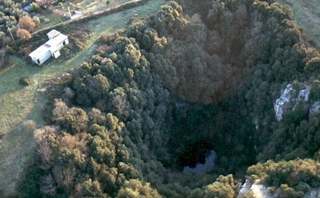
The small lake at the bottom of the Pozzo del Merro doline, the only entrance to a flooded shaft explored by research divers to 100 m and by ROV to 392 m. Access requires permission from the landholder ACEA.
The lake is reached from the south-eastern, lowest point of the doline rim by old masonry steps, a ledge path and finally an iron ladder. Its surface is covered with small floating green plants.
Below the water the shaft drops steeply with side chambers at about 30 and 60 m and a sizeable meander at 160 m. The cave sheet estimates that between 50 and 100 research dives were made from 1998 to 2002, leaving lines and guide ropes in place in the flooded shaft.
البيئة
A steep, smooth-walled flooded shaft with clay deposits and a ledge near 70 m that only a diver or a free-swimming robot can pass; debris that has fallen from above lies in the conduit.
للتوجه العام، لا للملاحة. النقاط المفرغة تحديد تقريبي.
كل حقيقة في هذه الصفحة مع مصدرها (8)
| حقيقة | الحالة | المصدر |
|---|---|---|
| The floor of the flooded shaft lies 392 m below the lake surface. | موثق | [1] [2] |
| Between 1998 and 2002 an estimated 50 to 100 research dives were made, and lines and ropes were left in the shaft. | موثق | [1] |
| A ledge at about 70 m depth can only be passed by a diver or a robot able to move freely in the water. | موثق | [2] |
| Water temperature is about 15-16 °C all year. | موثق | [2] |
| The cave is on fenced land and permission must be requested from ACEA, which manages the area.Sheet undated. | موثق | [1] |
| ACEA permission is required. | موثق | [1] |
| Area-level position derived from the register coordinates 42°02'19" N, 12°40'50" E. | موثق | [1] |
| Area-level position derived from the register coordinates. | موثق | [1] |
موثق: مُصرَّح به من مصدر رسمي أو أولي فتحناه. مُبلَّغ عنه: من مصدر ثانوي فقط. المصادر متضاربة: تتضمن الملاحظة النسختين. قد يكون قديماً: أحدث مصدر وجدناه قديم.
مكتوب بأسلوبنا الخاص من المصادر أعلاه. الإبلاغ عن تصحيح