어디서 다이빙할지, 언제 갈지, 무엇을 볼 수 있을지 알아보세요.

어디서 다이빙할지, 언제 갈지, 무엇을 볼 수 있을지 알아보세요.
★
메뉴
목적지 다이브 사이트 해양 생물 난파선 뉴스
여행 계획하기 트립 플래너 다이빙 시기 비용 계산기 비교 해양 생물 캘린더 수온 리브어보드 운영업체 & 리조트 해양공원 고압산소치료 챔버 세계 지도
동굴 다이빙 동굴 다이빙 전체 다이빙 목적지 & 다이브 사이트 동굴 시스템 및 지도 교육 & 자격 다이브 센터 & 가이드 장비 & 기술 안전 및 사고 연구 과학, 역사 & 보전 자료 및 업데이트
지역 호주, 뉴질랜드 & 동아시아카리브해 & 서대서양유럽, 대서양 & 지중해인도양 및 동아프리카태평양 제도 & 미크로네시아홍해 & 중동동남아시아 & 코랄 트라이앵글아메리카 & 동태평양 국가
학습 & 도구 전체 가이드 자격증 장비 가이드 영상 데이터에게 묻기 AI 에이전트 API
소개 소개 방법론 면책 조항 문의
내 보기
★ 저장됨

이 브라우저에 저장된 즐겨찾기 목적지, 다이빙 사이트, 생물 목록입니다.

API 게이트웨이

아틀라스의 캐시 데이터에 대한 무료 읽기 전용 JSON 접근.

다크 모드

가이드 보기
다이빙이 처음이신가요? 수심, 조류, 자격증 레벨이 궁금하신가요? 브라우징하면서 모든 용어를 쉬운 말로 설명해드립니다. 동일한 데이터에 도움말이 내장되어 있습니다.

전문가 보기
월 다이빙과 드리프트 다이빙의 차이는 이미 잘 아시죠. 데이터만 간결하고 빠르게 제공합니다. 기본 보기입니다.

인터페이스 언어
Pozzo del Merro (lake)

Pozzo del Merro (lake)

싱크홀까지 392 mPozzo del MerroItaly
사진: Francesco Cervoni · CC BY-SA 4.0
제한된 접근 Inside a fenced area within the Macchia di Gattaceca e Macchia del Barco nature reserve; permission must be requested from ACEA. 출입 규정은 변경될 수 있습니다. 여행 전에 토지 소유자 또는 관할 기관에 확인하세요.
충분히 검증됨 별칭: Pozzo del Merro, Il Merro
입구 수심
미공개
주요 다이빙 구역
미공개
이 지점의 최대 수심
392 m (1,286 ft)
공개된 카테고리
공개된 항목 없음
수온
15–16 °C

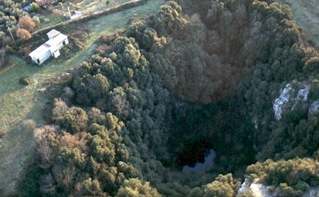
The small lake at the bottom of the Pozzo del Merro doline, the only entrance to a flooded shaft explored by research divers to 100 m and by ROV to 392 m. Access requires permission from the landholder ACEA.

The lake is reached from the south-eastern, lowest point of the doline rim by old masonry steps, a ledge path and finally an iron ladder. Its surface is covered with small floating green plants.

Below the water the shaft drops steeply with side chambers at about 30 and 60 m and a sizeable meander at 160 m. The cave sheet estimates that between 50 and 100 research dives were made from 1998 to 2002, leaving lines and guide ropes in place in the flooded shaft.

환경

A steep, smooth-walled flooded shaft with clay deposits and a ledge near 70 m that only a diver or a free-swimming robot can pass; debris that has fallen from above lies in the conduit.

Pozzo del Merro (lake) 위성 이미지: NASA Blue Marble

방향 파악용이며 내비게이션용이 아닙니다. 빈 점은 대략적인 위치입니다.

출처: [1] Parchi Lazio (Regione Lazio protected areas) ↗[2] ISPRA (APAT) ↗ · 확인됨 2026-10-14
이 페이지의 모든 정보와 출처 (8)
정보 항목상태출처
The floor of the flooded shaft lies 392 m below the lake surface. 확인됨 [1] [2]
Between 1998 and 2002 an estimated 50 to 100 research dives were made, and lines and ropes were left in the shaft. 확인됨 [1]
A ledge at about 70 m depth can only be passed by a diver or a robot able to move freely in the water. 확인됨 [2]
Water temperature is about 15-16 °C all year. 확인됨 [2]
The cave is on fenced land and permission must be requested from ACEA, which manages the area.Sheet undated. 확인됨 [1]
ACEA permission is required. 확인됨 [1]
Area-level position derived from the register coordinates 42°02'19" N, 12°40'50" E. 확인됨 [1]
Area-level position derived from the register coordinates. 확인됨 [1]

확인됨: 직접 열람한 공식 또는 1차 출처에서 명시된 정보입니다. 보고됨: 2차 출처에서만 확인된 정보입니다. 출처 간 상충: 비고에 두 가지 내용이 모두 기재되어 있습니다. 최신 정보가 아닐 수 있음: 확인된 가장 최근 출처가 오래된 경우입니다.

위의 출처를 바탕으로 자체적으로 작성했습니다. 수정 사항 제보

호주, 뉴질랜드 & 동아시아

Cairns & the Ribbon ReefsNingaloo ReefCoral Sea & Osprey ReefOkinawa & the Kerama IslandsPoor Knights IslandsTownsville & the YongalaGreen IslandIzu Peninsula

카리브해 & 서대서양

BonaireCozumelRiviera Maya & the CenotesBelize Barrier ReefGrand CaymanIsla Mujeres & CancúnRoatánTiger Beach & Grand Bahama

유럽, 대서양 & 지중해

Malta & GozoSilfra & IcelandThe AzoresCanary IslandsLarnaca & the ZenobiaScapa FlowArctic NorwayMadeira

인도양 및 동아프리카

North & South Malé AtollsAri AtollBaa Atoll & Hanifaru BayAliwal Shoal & UmkomaasMafia IslandMauritiusSeychellesSodwana Bay

태평양 제도 & 미크로네시아

PalauChuuk (Truk) LagoonFakaravaKona, HawaiʻiRangiroaTaveuni & Rainbow ReefBeqa Lagoon & Pacific HarbourEspiritu Santo

홍해 & 중동

Sharm El Sheikh & Ras MohammedBrothers, Daedalus & St John'sDahabHurghada & El GounaMarsa Alam & the Deep SouthAqabaDaymaniyat IslandsMusandam Peninsula

동남아시아 & 코랄 트라이앵글

Bali & Nusa PenidaKomodoRaja AmpatSipadan & MabulAnilaoCoronKoh TaoLembeh Strait

아메리카 & 동태평양

Galápagos IslandsCocos IslandFlorida KeysSea of Cortez & Cabo PulmoSocorro & the RevillagigedosBritish ColumbiaCalifornia Channel IslandsCosta Rica Pacific Coast