Scopri dove immergerti, quando andare e cosa potresti vedere.

Scopri dove immergerti, quando andare e cosa potresti vedere.
★
Menu
Destinazioni Siti di immersione Vita marina Relitti Notizie
Pianifica un viaggio Pianificatore di viaggi Quando immergersi Calcolatore dei costi Confronti Calendario della fauna marina Temperatura dell'acqua Liveaboard Operatori & resort Parchi marini Camere iperbariche Mappa del mondo
Immersioni in grotta Tutta la speleologia subacquea Destinazioni e siti di immersione Sistemi di grotte e mappe Formazione e qualifiche Diving center e guide Attrezzatura e tecnologia Sicurezza e ricerca sugli incidenti Scienza, storia e conservazione Risorse e aggiornamenti
Regioni Australia, Nuova Zelanda e Asia OrientaleCaraibi e Atlantico occidentaleEuropa, Atlantico e MediterraneoOceano Indiano e Africa OrientaleIsole del Pacifico & MicronesiaMar Rosso & Medio OrienteAsia meridionale e Triangolo dei CoralliLe Americhe e il Pacifico orientale Paesi
Impara e strumenti Tutte le guide Brevetti Guide all'attrezzatura Video Interroga i dati AI Agent API
Informazioni Chi siamo Metodologia Disclaimer Contatti
La tua vista
★ Salvato

Le tue destinazioni, siti e specie preferiti, salvati in questo browser.

API GATEWAY

Accesso JSON gratuito in sola lettura ai dati in cache dell'atlante.

Modalità scura

Visualizzazione Guidata
Sei alle prime armi con le immersioni? Profondità, correnti, livelli di certificazione? Spieghiamo ogni termine mentre navighi, in modo semplice e chiaro. Gli stessi dati, con tutto il supporto integrato.

Visualizzazione Esperta
Conosci già la differenza tra una parete e una drift dive. Solo i dati: chiari, rapidi e sintetici. Questa è la visualizzazione predefinita.

Lingua dell'interfaccia
Engelbrecht Cave

Engelbrecht Cave

Grotta subacquea22 m profondoAustralia, South Australia
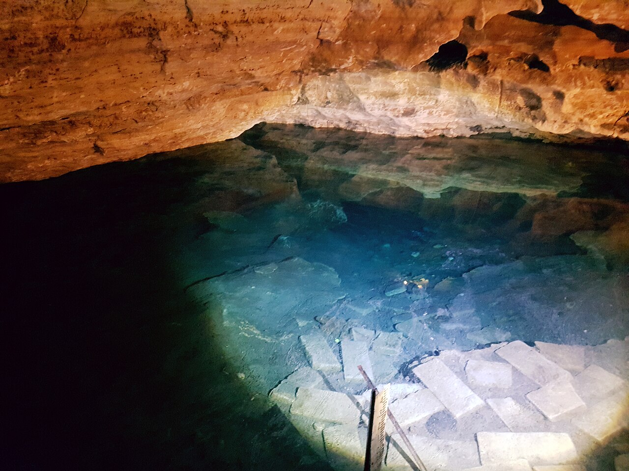
Foto: User:Satellizer · CC BY-SA 4.0
Aperto a subacquei qualificati, con condizioni · come pubblicato 2026-10-14 Owned by the City of Mount Gambier; diving is booked by CDAA members through the CDAA, with keys collected from the Lady Nelson Visitor Centre and diving allowed between 08:00 and 20:00. Le regole di accesso cambiano: conferma con il proprietario del terreno o l'autorità di gestione prima di partire.
Documentato Conosciuto anche come: Engelbrechts Cave, Engelbrecht's Cave, Englebrecht Cave, Englebrechts Cave, 5L19, 5L20, EEX, Engelbrechts East Extension
Sviluppo rilevato
Non pubblicato
Profondità documentata
22 m (72 ft)
Accessi elencati
2

CDAA figures: East passage max 8 m, West passage max 12 m, East Extension max 22 m.

A council-owned show cave in central Mount Gambier with two flooded passages, East (Cave-rated, about 70 m) and West (Advanced Cave, about 340 m), plus the Advanced Cave East Extension with more than 400 m of passage.

Engelbrecht Cave sits beneath a doline (a collapse sinkhole) in the middle of Mount Gambier and is named after Carl Engelbrecht, a 19th-century German settler. The City of Mount Gambier owns it and a tour operator runs guided visits of the dry cave and sinkhole for the public, with a café and viewing platforms at the surface.

Two submerged passages lead off in opposite directions. The East passage, reached by a short stairway inside the eastern tourist cave, is a low, silty tunnel of about 70 m to an inner air chamber. The West passage is reached down a long stone stairway to a small pool; after a narrow restriction (a section where passage size limits how divers can move) the first sump runs about 100 m to an air chamber and rock pile, beyond which a second, usually very clear sump continues.

From the East passage air chamber, Advanced Cave divers can climb over the rock pile to the East Extension (EEX), where the CDAA describes more than 400 m of submerged tunnel, several dry squeezes and seasonal water-level changes. The CDAA treats EEX as a sidemount-only site and does not allow training there.

Acqua, corrente e allagamenti

The CDAA warns that storm water can enter the West passage's first sump after heavy rain, so visibility there swings between very clear and zero; the second sump is usually clear. Water levels in the East Extension's 'Rabbit Hole' vary seasonally from almost dry to fully submerged.

Condizioni

Visibility in the West passage first sump depends on recent rain; silty sections can drop to zero visibility if disturbed.

Intervalli tipici da fonti pubblicate, non condizioni attuali.

Accessi e siti di immersione

Two dive entrances inside the show cave: East (5L19) and West (5L20). The East Extension is reached on foot through the East passage air chamber. Divers collect keys from the city visitor centre.

Per orientamento, non per navigazione. I punti vuoti sono approssimativi.

Fonti: [1] Cave Divers Association of Australia ↗[2] Cave Divers Association of Australia ↗[3] Cave Divers Association of Australia ↗[4] Cave Divers Association of Australia ↗[5] OpenStreetMap ↗ · verificato 2026-10-14
Ogni informazione in questa pagina, con la relativa fonte (8)
InformazioneStatoFonte
The East Extension features more than 400 m of submerged tunnel with a maximum depth of 22 m. Verificato [3]
The East passage extends about 70 m with a maximum depth of 8 m; the West passage extends about 340 m with a maximum depth of 12 m. Verificato [1] [2]
A private tour operator manages the site for the City of Mount Gambier; divers collect a key from the Lady Nelson Visitor Centre and may dive between 8 AM and 8 PM daily. Verificato [1] [2]
The CDAA rates the East passage Cave and the West passage and East Extension Advanced Cave. Verificato [1] [2] [3] [4]
The East Extension is an advanced sidemount-only site, Cave-rated divers must not go beyond the main chamber rock pile, and no training is allowed there. Verificato [3]
The West passage first sump can be contaminated by storm water after heavy rain, so visibility ranges from crystal clear to zero. Verificato [2]
Coordinates are the mapped cave entrance of the public show cave in Chute Street, Mount Gambier.Public tourist site. Verificato [5]

Verificato: dichiarato da una fonte ufficiale o primaria che abbiamo consultato. Segnalato: da una fonte secondaria soltanto. Le fonti sono in contrasto: la nota riporta entrambe le versioni. Potrebbe essere non aggiornato: la fonte più recente che abbiamo trovato è datata.

Scritto con parole nostre dalle fonti indicate sopra. Segnala una correzione

Australia, Nuova Zelanda e Asia Orientale

Cairns & the Ribbon ReefsNingaloo ReefCoral Sea & Osprey ReefOkinawa & the Kerama IslandsPoor Knights IslandsTownsville & the YongalaGreen IslandIzu Peninsula

Caraibi e Atlantico occidentale

BonaireCozumelRiviera Maya & the CenotesBelize Barrier ReefGrand CaymanIsla Mujeres & CancúnRoatánTiger Beach & Grand Bahama

Europa, Atlantico e Mediterraneo

Malta & GozoSilfra & IcelandThe AzoresCanary IslandsLarnaca & the ZenobiaScapa FlowArctic NorwayMadeira

Oceano Indiano e Africa Orientale

North & South Malé AtollsAri AtollBaa Atoll & Hanifaru BayAliwal Shoal & UmkomaasMafia IslandMauritiusSeychellesSodwana Bay

Isole del Pacifico & Micronesia

PalauChuuk (Truk) LagoonFakaravaKona, HawaiʻiRangiroaTaveuni & Rainbow ReefBeqa Lagoon & Pacific HarbourEspiritu Santo

Mar Rosso & Medio Oriente

Sharm El Sheikh & Ras MohammedBrothers, Daedalus & St John'sDahabHurghada & El GounaMarsa Alam & the Deep SouthAqabaDaymaniyat IslandsMusandam Peninsula

Asia meridionale e Triangolo dei Coralli

Bali & Nusa PenidaKomodoRaja AmpatSipadan & MabulAnilaoCoronKoh TaoLembeh Strait

Le Americhe e il Pacifico orientale

Galápagos IslandsCocos IslandFlorida KeysSea of Cortez & Cabo PulmoSocorro & the RevillagigedosBritish ColumbiaCalifornia Channel IslandsCosta Rica Pacific Coast