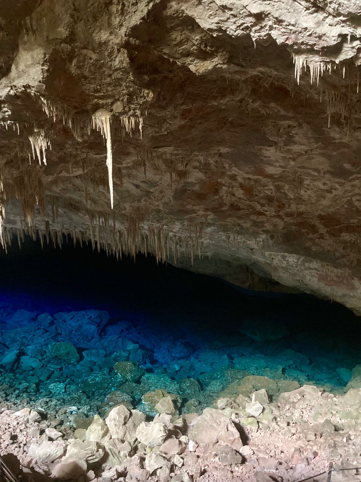
Gruta do Lago Azul
A 2002 magazine article gives the lake as 90 m deep; no published survey was found, so treat this as approximate.
A protected limestone cave near Bonito whose sloping main chamber ends in a clear underground lake, where divers found Pleistocene mammal bones in 1992. Public visits are guided walking tours; no public diving offer was found.
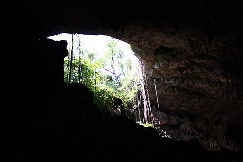
Gruta do Lago Azul is a limestone cave about 21 km from Bonito. A circular entrance about 40 m across lets sunlight into a large chamber whose floor slopes steeply down to an underground lake more than 50 m long. When sunlight strikes the water, for part of each year, the lake turns an intense blue that gives the cave its name. It is one of Bonito's best-known landmarks and was listed by Brazil's national heritage institute IPHAN in 1978.
In 1992 a team of Brazilian and French divers found bones of extinct Pleistocene mammals on the lake floor, including giant ground sloths, armadillos and sabre-toothed cats. Sources give their age as roughly 10,000 to more than 12,000 years. The lake is also home to Potiicoara brasiliensis, a blind, unpigmented crustacean about 7 mm long first identified there in the late 1980s.
The cave is part of a state Natural Monument whose management plan was approved by the Mato Grosso do Sul environment institute IMASUL in July 2022. Because caves are federal property, the federal government ceded the cave to the municipality of Bonito in 2021 for 20 years, and the municipality runs the visits.
Visits are guided walking tours. The state visitation order reviewed for this record (2012) covered contemplative visits only and said nothing about diving, and no current public diving offer was found. The lake is therefore listed here for its scientific importance, not as a dive site.
Warum es wichtig ist
Divers' finds on the lake floor in 1992 revealed a deposit of Pleistocene large-mammal bones, including giant sloths, armadillos and sabre-toothed cats. The lake is also known for cave-adapted aquatic fauna, including the 7 mm crustacean Potiicoara brasiliensis; a 2002 report said eight troglobitic (cave-restricted) aquatic species had been identified in Bonito's caves.
Bedingungen
Sunlight reaches the lake in the morning in some months; sources give September to February for the strongest blue colour. Visits are walking tours, so water conditions are not published.
Typische Wertebereiche aus veröffentlichten Quellen, keine aktuellen Bedingungen.
Kartierungs- und Erkundungsgeschichte
| 1924 | The cave was found by Terena Indigenous people, according to a show-cave reference. [5] |
| 1978 | IPHAN listed the cave as protected heritage. [4] [6] |
| 1985 | The first gate restricting unlimited tourist access was installed. [7] |
| 1992 | Brazilian and French divers found Pleistocene mammal bones on the lake floor. [3] [5] |
| 2012-12-20 | IMASUL authorised contemplative tourist visits with a daily cap of 305 visitors. [1] |
| 2021-01-20 | The federal Secretariat of Union Property authorised ceding the cave to the municipality of Bonito for 20 years. [4] |
| 2022-07-12 | IMASUL approved the Natural Monument's management plan. [2] |
Zugänge und Tauchplätze
One large circular entrance, about 40 m across, reached on guided tours.
Alle Angaben auf dieser Seite mit Quellennachweis (16)
| Angabe | Status | Quelle |
|---|---|---|
| The circular entrance is about 40 m in diameter and the underground lake is more than 50 m long. | Gemeldet | [4] [6] |
| The cave was listed by IPHAN in 1978.IPHAN's own document could not be opened (link redirects). | Gemeldet | [4] [6] |
| The underground lake is 90 m deep.Single figure from a 2002 magazine article; no survey found. | Möglicherweise veraltet | [3] |
| The cave is 143 m long and 80 m wide with a sloping floor.2002 figure. | Möglicherweise veraltet | [3] |
| In 1992 divers found bones of Pleistocene mammals on the lake floor, including giant ground sloths, armadillos and sabre-toothed cats.No peer-reviewed description of the deposit was found in this review. | Gemeldet | [3] [5] [4] |
| The animals' age is given as about 12,000 years (FAPESP, 2002; over 12,000 years in the 2021 report) or about 10,000 years (Showcaves).Sources disagree; neither cites a dating study. | Quellen widersprechen sich | [3] [4] [5] |
| Potiicoara brasiliensis, a blind, unpigmented spelaeogriphacean crustacean about 7 mm long, was identified in the lake in the late 1980s and described by Ana Maria Pires Vanin of USP's Oceanographic Institute.2002 science magazine; original description not opened. | Gemeldet | [3] |
| Eight troglobitic aquatic species had been identified in Bonito's caves as of 2002.2002 figure attributed to researcher Nicoletta Moracchioli. | Möglicherweise veraltet | [3] |
| The first gate restricting unlimited tourist access was installed in 1985, and the municipal government administers the visits, one of the few Bonito attractions under government control. | Gemeldet | [7] |
| IMASUL Portaria 257/2012 authorised contemplative tourist visits only, with up to 305 visitors per day, groups of up to 15 plus a guide, at least 20 minutes between groups and no more than four groups inside at once; the authorisation ran to 31 December 2013.2012 document; current visitor limits under the 2022 management plan were not available online in a readable form. | Möglicherweise veraltet | [1] |
| The 2012 order required a local guide registered with EMBRATUR and Bonito's tourism register, a voucher único issued by the municipality or authorised agencies, a helmet with three-point fastening and closed rubber-soled shoes.2012 rules. | Möglicherweise veraltet | [1] |
| The 2012 visitation order does not mention diving.Absence of authorisation; no current public diving offer was found in any source reviewed. | Verifiziert | [1] |
| IMASUL approved the Natural Monument's management plan by Portaria 1.111 of 12 July 2022. | Verifiziert | [2] |
| In January 2021 the federal Secretariat of Union Property (SPU Portaria 496/2021) authorised ceding the cave to the municipality of Bonito for 20 years, with the municipality responsible for managing visits. | Gemeldet | [4] |
| Between September and February sunlight on the water makes it an intense blue.FAPESP (2002) gives December and January for sunlight reaching the lake; Showcaves gives about 07:30-09:30 each morning. | Gemeldet | [4] |
| The cave is about 21 km from Bonito, on the former Anhumas farm.Show-cave reference. | Gemeldet | [5] |
Verifiziert: von einer offiziellen oder primären Quelle bestätigt, die wir geöffnet haben. Gemeldet: nur aus einer Sekundärquelle. Quellen widersprechen sich: Die Anmerkung enthält beide Versionen. Möglicherweise veraltet: Die neueste von uns gefundene Quelle ist alt.
In eigenen Worten aus den oben genannten Quellen verfasst. Korrektur melden