Lagoa Misteriosa
Depth reached on a 1998 exploration dive without seeing the bottom; total depth unknown. Not a visitor dive depth.
A flooded sinkhole at the bottom of a forested doline about 75 m deep in Jardim, near Bonito. A diver reached 220 m in 1998 without seeing the bottom; visitors snorkel or dive to set limits, with technical dives arranged by consultation.
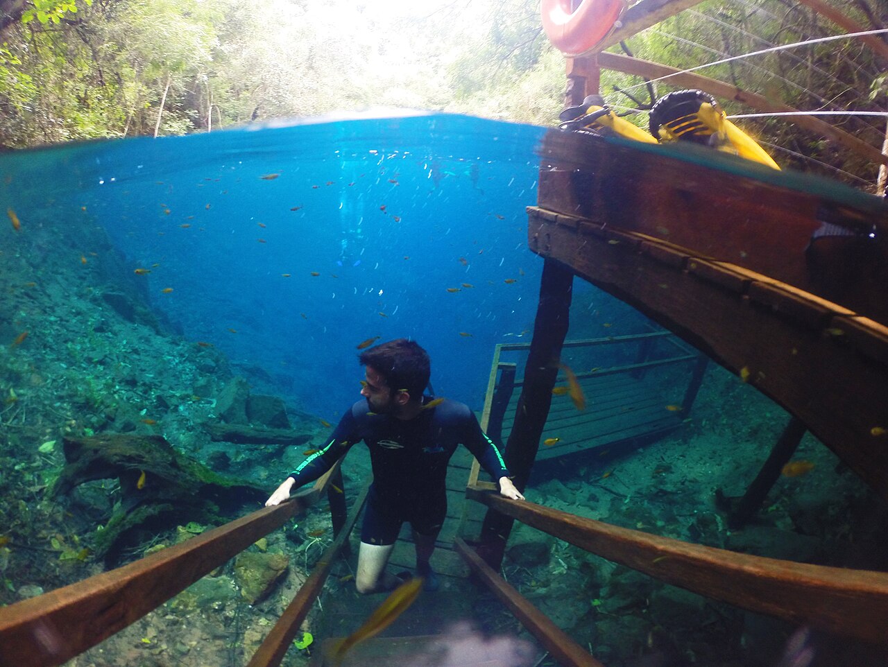
Lagoa Misteriosa is a water-filled sinkhole on a rural property in Jardim, Mato Grosso do Sul, belonging to the Grupo Rio da Prata group of attractions. The lake lies at the foot of a forest-covered doline (a closed limestone depression) about 75 m deep and continues downward as a largely vertical flooded shaft whose bottom has never been reached.
In 1998 the diver Gilberto Menezes de Oliveira reached 220 m without seeing the bottom. The operator stresses that this is an exploration depth, not the depth of visitor dives. In August 2008, a team of 13 cave divers supervised by Tuta Barroco mapped the shaft to 70 m as part of a management plan for the federal environment agency Ibama.
The attraction was closed in 2005 for lack of an environmental licence and reopened in late July 2011 after the state environment agency IMASUL issued its operating licence. The operator now offers snorkelling and scuba diving in published categories, from an introductory dive to 8 m up to advanced dives to 30 m, plus technical diving booked by consultation on the basis of a dive plan.
Water clarity follows the seasons. Microalgae bloom roughly from mid-October to mid-April, when average daily temperatures exceed about 26 °C, turning the blue water green; introductory and basic dives and snorkelling are suspended then, while advanced and technical dives may go ahead if visibility allows. The operator gives the water temperature as a constant 24 °C.
地質学
The lake occupies the bottom of a limestone doline about 75 m deep, covered in forest. Below the surface the cavity behaves as a vertical flooded cave, which a 2008 mapping report noted lets divers descend to great depth.
水、水流、洪水
The operator gives a constant water temperature of 24 °C. Seasonal microalgae blooms, which it links to daily average air temperatures above about 26 °C and to nutrient input, reduce visibility from roughly mid-October to mid-April; it says reforestation and soil-conservation works around the doline have made blooms less intense.
なぜ重要か
Press reports describe Lagoa Misteriosa as the deepest known flooded cave in Brazil, and its true depth remains unknown. It is one of the longest-established dive sites in the Bonito region.
コンディション
Visibility of up to 40 m is described for snorkelling in the clear-water season. Algae season runs roughly mid-October to mid-April (the operator's pages give slightly different start months); introductory and basic dives are suspended then. Press reports in 2025 described the visiting season as April to September. Heavy rain can cancel or interrupt visits.
公表資料からの一般的な範囲であり、現在のコンディションではありません。
測量と探査の歴史
| 1998 | Diver Gilberto Menezes de Oliveira reached 220 m without seeing the bottom. [1] [2] |
| 2005 | The attraction was closed for lack of an environmental licence. [3] |
| 2008-08 | Thirteen cave divers supervised by Tuta Barroco mapped the shaft to 70 m for a management plan to be submitted to Ibama. [2] |
| 2011-07 | IMASUL issued an operating licence on 22 July 2011 and the site reopened to visitors later that month. [3] |
入口とダイブサイト
One water entrance at the foot of the doline, reached by a trail of about 1,100 m round trip and a stairway of 185 steps.
このページのすべての情報とその出典 (18)
| 情報 | ステータス | 出典 |
|---|---|---|
| In 1998 the diver Gilberto Menezes de Oliveira reached 220 m without seeing the bottom; this is an exploration depth, not a visitor dive depth.Stated by the operator and in a 2008 SBE bulletin item reproduced from the press; no published survey of the full depth exists. | 報告済み | [1] [2] |
| The lake lies at the bottom of a forested doline about 75 m deep.Operator and press figure. | 報告済み | [4] [3] |
| From 12 August 2008, 13 cave-diving specialists supervised by Tuta Barroco mapped the lake to 70 m depth as part of a management plan to be sent to Ibama.2008 press item reproduced in the SBE bulletin; the resulting map was not found online. | 報告済み | [2] |
| The site was closed in 2005 for lack of environmental licensing and reopened in late July 2011 after IMASUL granted its operating licence on 22 July 2011.2011 press report. | 報告済み | [3] |
| Press reports describe it as the deepest flooded cave in Brazil.No official ranking was opened for this record. | 報告済み | [3] |
| Water temperature is a constant 24 °C year-round.Operator figure. | 報告済み | [5] |
| Algae typically bloom from mid-October to mid-April, when the daily average temperature exceeds 26 °C, and basic and introductory diving are suspended in that period; advanced and technical dives may be possible if visibility allows.Operator pages differ slightly on the start month (s6 says from October; the dive page s4 describes a green-season advanced dive by consultation from September to March). | 確認済み | [5] [6] |
| Visibility of up to 40 m is described for snorkelling.Maximum, not typical. | 報告済み | [1] [7] |
| In 2025 the visiting season was reported as April to September.Press, 2025. | 報告済み | [7] [9] |
| The trail is about 1,100 m round trip and the stairway to the lagoon has 185 steps. | 確認済み | [4] |
| Visits must be booked through a travel agency; reservations are issued by accredited agencies in the region.Operator statement. | 確認済み | [8] [1] |
| Technical diving and check-out dives for trainee divers are booked by consultation, based on the dive plan. | 確認済み | [6] |
| Published dive categories are: introductory (no certification, 8 m); basic (Open Water, 18 m); advanced (Advanced Open Water, 30 m).The FAQ (s5) lists only the 8 m and 18 m categories; the dive page (s4) adds the 30 m advanced category. | 確認済み | [4] [5] |
| Minimum age for scuba is 10, and children under 12 must be accompanied by a parent or guardian. | 確認済み | [4] [5] [6] |
| Pregnancy, a history of spontaneous pneumothorax and pacemakers exclude visitors from diving; several other conditions require a signed liability waiver.The FAQ (s5) states a different pregnancy rule (allowed up to 24 weeks); the dive page and preliminary information page exclude pregnancy at any stage. | 確認済み | [4] [6] |
| A 2008 report called Lagoa Misteriosa one of the most traditional dive sites in Brazil and quoted the mapping supervisor describing it as one of the oldest dive sites around Bonito.2008 press item in the SBE bulletin. | 報告済み | [2] |
| The 2008 mapping report noted that the cave is vertical, which lets divers reach greater depths. | 報告済み | [2] |
| The operator says reforestation, retention boxes and contour terracing have reduced nutrient input and made algae blooms less intense, though their timing cannot be guaranteed.Operator statement. | 報告済み | [5] |
確認済み:直接開いた公式または一次情報源による記載。報告ベース:二次情報源のみによるもの。情報が競合:注釈に両方のバージョンを記載。最新情報でない可能性あり:確認できた最新の情報源が古い。
上記のソースをもとに、独自の言葉でまとめています。 修正を報告する