Ojamo Mine
No published total tunnel length was found. The main shaft is reported to reach about 250 m, but its exact depth is unknown because the shaft was partly filled after closure. The deepest recorded dive mentioned in 2013 was 160 m. Levels are reported at about 28, 56, 88 and 138 m below the pit floor.
A flooded former limestone mine in Lohja, west of Helsinki, with horizontal tunnel levels below an open-pit pond. One of Finland's busiest dive sites, but closed to outsiders: only the club and training bodies holding the city's operating rights dive there.
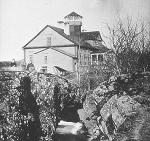
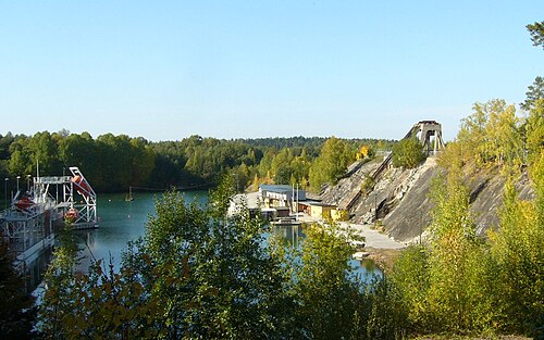
Ojamo is a former lime mine in the town of Lohja. Mining moved underground when the open pit became too deep, and work stopped in the mid-1960s when lime prices fell; afterwards the workings slowly filled with groundwater until the water reached ground level. The flooded open pit now forms a pond from which divers enter the tunnels.
The mine is laid out as horizontal levels at roughly constant depths, which makes it a classic example of a mine dive: long, regular tunnels with an overhead, in cold, very clear water. The shallowest dive level is about 20-28 m down, and the most commonly dived depths are around 28, 38 and 58 m, with deeper levels reserved for technical exploration.
Access is tightly controlled. Since 2024 the operating rights granted by the City of Lohja have been held by a divers' association, Ojamon kaivossukeltajat ry, alongside two professional training providers. Outsiders are not allowed into the area. About 2,000 dives a year are made there.
In late January 2026 a club member died during the ascent on the open-water side after a mine dive; the city said it had no plans to restrict diving unless the investigation showed a site-related cause.
Kondisi
About 4 °C at depth all year; surface water in the open pit warms to around 20 °C in summer and is then often murky (about 1 m or less), while the deep water is described as crystal clear (2013 magazine feature; no numeric deep-water visibility is published). Diving under ice requires cave or mine training.
Rentang tipikal dari sumber yang dipublikasikan, bukan kondisi saat ini.
Sejarah survei dan eksplorasi
| 2024 | Ojamon kaivossukeltajat ry receives operating rights to the mine pond from the City of Lohja. [1] |
| 2026-01 | A club diver dies during the ascent on the open-water side after a mine dive; the cause is investigated. [1] |
Pintu masuk dan lokasi selam
Divers enter from the flooded open pit (the mine pond), where the water is at ground level.
Setiap fakta di halaman ini, beserta sumbernya (9)
| Fakta | Status | Sumber |
|---|---|---|
| The City of Lohja's operating-rights holders for the pond are Meriturva, Luksia and Ojamon kaivossukeltajat ry, which received its rights in 2024; access for outsiders is prohibited.National broadcaster report of 2026-02-04 quoting the city and the club chair; no city document was opened. | Dilaporkan | [1] |
| About 2,000 dives a year are made at the site. | Dilaporkan | [1] |
| Diving under ice at Ojamo requires cave or mine diving training. | Dilaporkan | [1] |
| The main shaft reaches about 250 m, with the exact depth unknown because of fill placed after closure; the deepest recorded dive was 160 m.From a 2013 feature written by a local technical diver; no newer figure found. | Mungkin sudah tidak mutakhir | [2] |
| The most common dive depths are 28, 38 and 58 m and the shallowest dive level is about 20 m.The 2013 feature gives levels at about 28, 56, 88 and 138 m below the pit floor. | Dilaporkan | [1] |
| Water is about 4 °C at depth year-round, with surface water in the pit warming to about 20 °C in summer.2013 source. | Mungkin sudah tidak mutakhir | [2] |
| Summer surface water is often murky at about 1 m or less, while deep water is crystal clear.2013 source; no numeric deep-water visibility is published. | Mungkin sudah tidak mutakhir | [2] |
| Mining ended in the mid-1960s when lime prices fell, after which the mine slowly filled with groundwater. | Dilaporkan | [2] |
| A club member died in an accident on the open-water side during the ascent after a mine dive in late January 2026; the city said it had no plans to restrict diving.Cause under investigation at the time of the report. | Dilaporkan | [1] |
Terverifikasi: dinyatakan oleh sumber resmi atau sumber primer yang kami buka langsung. Dilaporkan: hanya dari sumber sekunder. Sumber berbeda pendapat: catatan menyajikan kedua versi. Mungkin sudah kedaluwarsa: sumber terbaru yang kami temukan sudah lama.
Ditulis dengan kata-kata kami sendiri berdasarkan sumber di atas. Laporkan koreksi