Sistema de caverna
Piccaninnie Ponds Karst Wetlands
Published as 'more than 110 metres' for the deepest springs (state environment department); the park page describes the Chasm as over 100 m deep. Divers are limited to 36.5 m.
A spring-fed karst wetland near the Victorian border whose groundwater springs reach more than 110 metres deep. It is a Ramsar-listed wetland and a CDAA-rated dive site, but in-water activities have been suspended since an algae outbreak.
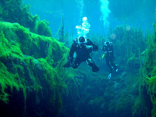
Piccaninnie Ponds is a coastal wetland about 32 km south-east of Mount Gambier, close to the Victorian border and the Southern Ocean. Groundwater rises under pressure through the limestone into a series of ponds; the dived part consists of a shallow, plant-filled First Pond, a deep fissure known as the Chasm, and an enclosed white limestone area called the Cathedral.
The main attraction for divers is exceptional water clarity combined with dense aquatic plants growing far below the surface. Diving is limited to CDAA members with the required rating, booked in one-hour slots through the state parks booking system and subject to a park depth limit.
The ponds were listed under the Ramsar Convention as a wetland of international importance in December 2012 and protect several nationally listed fish, crayfish and bird species. A park notice published in July 2024 suspended all diving and snorkelling while aquatic vegetation recovers from a filamentous algae outbreak; the park itself stays open to land-based visitors.
Água, fluxo e inundações
The ponds are fed by groundwater springs; the state environment department describes springs deeper than 110 metres and aquatic plants growing to about 15 metres below the surface in very clear water. The park service attributes the formation of the Chasm and Cathedral to fresh water rising under pressure and dissolving the limestone.
Por que isso importa
Designated a Ramsar wetland on 2012-12-21 (mainly as waterfowl habitat), meeting five of the nine Ramsar criteria. The state environment department records seven nationally or internationally listed animal species, including Yarra pygmy perch, dwarf galaxias and Glenelg spiny freshwater crayfish, and describes the site as one of the few permanent freshwater wetlands left in the lower South East.
Condições
The park service describes visibility as excellent and able to exceed 40 m. A filamentous algae outbreak has degraded vegetation, and the water has been closed to divers and snorkellers since the park notice of July 2024.
Faixas típicas de fontes publicadas, não as condições atuais.
Entradas e pontos de mergulho
One public dive area within the conservation park (First Pond, the Chasm and the Cathedral). No other entrances are open to divers.
Para orientação, não para navegação. Pontos vazados marcam posições aproximadas.
Cada informação desta página, com sua fonte (9)
| Informação | Status | Fonte |
|---|---|---|
| The wetland's groundwater springs reach more than 110 metres in depth.Stated as a lower bound. The park page describes the Chasm as a sinkhole over 100 m deep. | Verificado | [1] |
| Piccaninnie Ponds Karst Wetlands was designated a Ramsar site on 21 December 2012 and covers the 862-hectare conservation park. | Verificado | [1] |
| Aquatic vegetation grows to about 15 metres below the surface. | Verificado | [1] |
| Underwater visibility is described by the park service as excellent and may exceed 40 m.Describes typical clarity before the algae outbreak, not current conditions. | Verificado | [2] |
| Piccaninnie Ponds is closed to immersive water activities until further notice and permits for diving and snorkelling are not being issued, following a filamentous algae outbreak; the park remains open.Alert published 2024-07-11; the park page still showed the closure when viewed 2026-10-14. | Verificado | [2] [3] |
| Divers must be current financial CDAA members rated at sinkhole category, dive with at least one and at most three other divers, stay above 36.5 m and dive only in the First Pond, the Chasm and the Cathedral.Rules as published on the park page; they apply when permits are being issued. | Verificado | [2] |
| The CDAA site directory gives Piccaninnie Ponds (5L72) a Basic Cave rating with DEW as the land manager.'Sinkhole category' on the park page is older CDAA terminology. | Verificado | [4] |
| Area coordinates are the mapped centre of the conservation park.Park-level point, not a dive entry. | Verificado | [5] |
| Area coordinates are the mapped centre of the conservation park.Park-level point, not a dive entry. | Verificado | [5] |
Verificado: declarado por uma fonte oficial ou primária que consultamos. Relatado: proveniente apenas de uma fonte secundária. Fontes divergem: a nota apresenta as duas versões. Pode estar desatualizado: a fonte mais recente que encontramos é antiga.
Escrito com nossas próprias palavras a partir das fontes acima. Reportar uma correção