Système de grottes
Poço Azul
Single reference figure (pool 40 m long, 20 m wide, 60 m deep); fossils were recovered from up to 16.5 m. A survey by Rubbioli (1998, O Carste 10(1)) exists but was not opened.
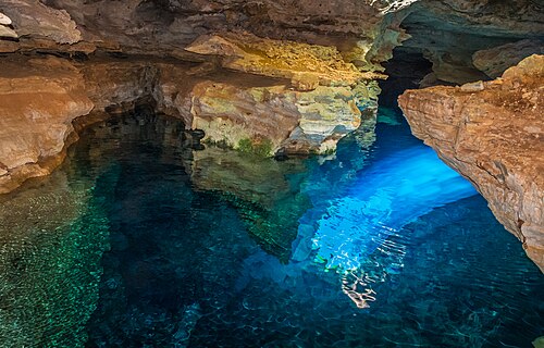
A flooded cave inside a collapse sinkhole by the Paraguaçu River in Nova Redenção, Chapada Diamantina. Cave divers recovered a rich Ice Age mammal fauna here in 2005, including a near-complete giant ground sloth; today visitors swim and snorkel.
Poço Azul, also recorded as Poço Azul do Milú, is a flooded cave in the municipality of Nova Redenção, on the banks of the Paraguaçu River in the Chapada Diamantina of central Bahia. Like many caves in the region it opens inside an asymmetric collapse sinkhole, about 50 m across, which cuts the water table some 30 m below the surface.
Fossil bones were discovered underwater in the cave in 1995. In 2005 a team specialising in cave diving recovered the material from depths of up to 16.5 m. The collection, curated by the palaeontology collection of the Museu de Ciências Naturais PUC Minas in Belo Horizonte, covers more than ten mammal species, living and extinct, including two ground-sloth species new to science and an articulated, almost complete skeleton of the giant ground sloth Eremotherium laurillardi.
Researchers describing the preparation of the sloth skeleton noted that because the bones fossilised underwater they preserve fine anatomical detail that is usually lost in specimens from dry cave deposits.
Today the pool is a popular swimming and snorkelling stop, with visitors issued life jackets and masks; a beam of sunlight reaches the water around midday for much of the year. None of the sources reviewed describe recreational scuba diving being offered, so diving access is listed as unknown.
Géologie
The cave lies in the carbonate karst of the Chapada Diamantina. It opens within an asymmetric collapse doline about 50 m in diameter that intersects the water table about 30 m below, a pattern typical of the region; its steep entrance probably acted as a natural trap for animals.
Pourquoi c'est important
Poço Azul is one of Brazil's most important underwater fossil sites. Material recovered by cave divers in 2005 includes more than ten mammal species, two previously unknown ground sloths and a near-complete Eremotherium laurillardi skeleton, unusually well preserved because it fossilised underwater.
Conditions
A sunbeam reaches the water around midday, roughly February to October according to tourism references; the timing differs between sources. Visitors are asked not to wear sunscreen, moisturiser or repellent and to shower before entering. No temperature or visibility figures from a primary source were found.
Fourchettes indicatives issues de sources publiées, pas les conditions actuelles.
Historique du relevé topographique et de l'exploration
| 1995 | Submerged fossil bones were discovered in the cave. [1] [2] |
| 1998 | Ezio Rubbioli published a topographic map of the cave in an article on cave diving in the Bahia backlands (O Carste 10(1)). [1] |
| 2005 | A specialised cave-diving team recovered the fossils from depths of up to 16.5 m. [1] [2] |
| 2016 | A paper in Terrae Didatica described the laboratory preparation of the Eremotherium laurillardi skeleton. [1] |
Entrées et sites de plongée
One entrance through the sinkhole, reached by a wooden staircase and platform used by visitors.
Pour s'orienter, pas pour naviguer. Les points creux sont approximatifs.
Chaque information de cette page, avec sa source (12)
| Information | Statut | Source |
|---|---|---|
| The cave lies within an asymmetric collapse doline about 50 m in diameter that intersects the water table about 30 m below.The paper cites Rubbioli (1998). | Vérifié | [1] |
| The cave is on the banks of the Paraguaçu River in the municipality of Nova Redenção, Chapada Diamantina, Bahia. | Vérifié | [1] |
| The fossils were discovered in 1995 and recovered in 2005 by a team specialised in cave diving from a maximum depth of 16.5 m.Showcaves (s2) gives about 15 m and names diver Túlio Schargel as the 1995 discoverer. | Vérifié | [1] |
| The collection includes more than ten mammal species, two new ground-sloth species and an articulated, almost complete Eremotherium laurillardi skeleton, curated at the Museu de Ciências Naturais PUC Minas. | Vérifié | [1] |
| Because fossilisation happened underwater, the material preserves morphological detail not seen in other E. laurillardi fossils from dry settings. | Vérifié | [1] |
| The cave map used in the 2016 paper is modified from Rubbioli (1998), and the authors credit Ezio Rubbioli of the Grupo Bambuí de Pesquisas Espeleológicas for material on the cave. | Vérifié | [1] |
| A show-cave reference gives the pool as 40 m long, 20 m wide and 60 m deep.Single tourism reference; primary survey not opened. | Signalé | [2] |
| Swimming is allowed; snorkel, mask and life jacket are supplied at check-in; visitors should shower first and avoid sunscreen and creams.Showcaves page (fees on it are 2020 data). | Signalé | [2] |
| A Bahia tourism guide describes Poço Azul as a floating (snorkelling) experience.Published 2013, updated 2025-07-02. | Signalé | [3] |
| The visitors' meeting point at Restaurante Dona Alice, Povoado Piruca, is at about 12.782 S, 41.149 W.Area-level coordinate of the public check-in point, not of the cave. | Signalé | [2] |
| The best light on the water is given as 8 February to 20 October, around midday; the stated hours differ within the source. | Signalé | [2] |
| Because the entrance is vertical and hard to reach, the animals preserved in the cave probably fell in by accident.Interpretation by the paper authors. | Vérifié | [1] |
Vérifié : indiqué par une source officielle ou primaire que nous avons consultée. Signalé : issu d'une source secondaire uniquement. Sources contradictoires : la note présente les deux versions. Peut être obsolète : la source la plus récente que nous avons trouvée est ancienne.
Rédigé dans nos propres mots à partir des sources ci-dessus. Signaler une correction