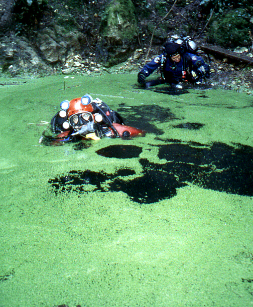
Pozzo del Merro
Depth below the lake surface reached by a fire-brigade ROV in March 2002. The regional cave sheet gives a total vertical range of -450 m from ground level.
A flooded karst sinkhole in the Monti Cornicolani north-east of Rome whose water-filled shaft was surveyed by remotely operated vehicles to a floor 392 m below the lake surface in 2002. It is a research site inside a regional nature reserve, not a recreational dive.
The Pozzo del Merro is a funnel-shaped doline (a collapse or solution hollow in limestone) about 150 m across at ground level, narrowing to a small lake roughly 25 to 30 m wide that lies around 60 to 70 m below the rim. Masonry steps built in the 1970s and an iron ladder lead down to the lake edge.
Below the lake a karst conduit descends first vertically and then at about 70 degrees, narrowing to about 5 m wide at 40 m and continuing with alternating constrictions and wider sections to a flat, silt-covered floor at 392 m. Divers working with Sapienza University of Rome and the fire brigade reached 70 m in 1998 and 100 m in 1999; deeper work was done with fire-brigade ROVs (remotely operated vehicles), which reached 200 m and 310 m in 2000 and the floor in March 2002.
The site sits within the Macchia di Gattaceca e Macchia del Barco nature reserve on fenced land managed by the Rome water utility ACEA, whose permission is required for access according to the regional cave sheet.
The Merro is significant as one of the deepest known water-filled sinkholes on Earth. Researchers interpret it as formed by dissolution from below by mineralised fluids rising from depth, a process sometimes called hyperkarst.
الجيولوجيا
The sinkhole opens in compact carbonate rock of the Monti Cornicolani near volcanic structures; its walls show intense dissolution, and the floor is covered with red clayey silt left by dissolving limestone. The research paper interprets its origin as inverse (bottom-up) dissolution by rising geothermal and mineralised fluids.
المياه والتدفق والفيضانات
The lake is an outcrop of the regional aquifer of the Monti Cornicolani, of calcium-bicarbonate type with modest sulphide input from deep fluids. Water temperature is around 15 to 16 °C throughout the water column, year-round.
لماذا يهم ذلك
Described by its researchers as one of the two deepest flooded open sinkholes known, alongside El Zacatón in Mexico, and a test case for using scientific diving and ROVs to study deep flooded karst.
تاريخ المسح والاستكشاف
| 1928-09-23 | The Circolo Speleologico Romano explores the sinkhole. [2] |
| 1998 | Divers G. Caramanna and R. Malatesta reach 70 m in a Sapienza University research programme supported by the fire brigade. [2] |
| 1999 | Further dives reach 100 m below the lake surface. [2] |
| 2000-04 | Fire-brigade ROVs reach 200 m and then 310 m without touching bottom. [2] |
| 2002-03 | A fire-brigade ROV from Milan touches the floor at 392 m. [2] |
المداخل ومواقع الغوص
A single entrance: the lake at the bottom of the doline, reached by steps and a ladder on fenced land.
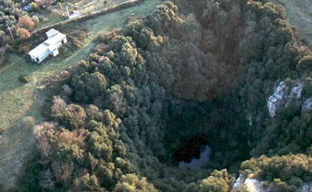
للتوجه العام، لا للملاحة. النقاط المفرغة تحديد تقريبي.
مزيد من القراءة
A short history of underwater cave exploration: dated milestones
Conservation, landowners and responsible access
How underwater caves form: karst, dissolution and drowned passages
Threats to underwater caves today, and how they are protected
Il sinkhole allagato del Pozzo del Merro: 20 anni di esplorazione e studio (The Pozzo del Merro drowned sinkhole: 20 years of exploration and study) ↗
كل حقيقة في هذه الصفحة مع مصدرها (11)
| حقيقة | الحالة | المصدر |
|---|---|---|
| In March 2002 a fire-brigade ROV touched the bottom at 392 m below the water surface. | موثق | [1] [2] |
| The cave register gives a vertical range of -450 m. | موثق | [2] |
| The doline is about 150 m across at the rim and narrows to a lake about 25 m (paper) or about 30 m (cave sheet) across, some 70 m (paper) or 58 m by the descent route (cave sheet) below ground level.Figures differ slightly between the two sources depending on measuring point. | المصادر متضاربة | [1] [2] |
| Divers reached 70 m in 1998 and 100 m in 1999; ROVs reached 200 m and 310 m in 2000. | موثق | [2] |
| Water temperature is constant year-round through the water column at about 15-16 °C. | موثق | [1] |
| Water temperature is about 15-16 °C. | موثق | [1] |
| The genesis of the sinkhole is attributed to inverse dissolution of the limestone by rising fluids, a strongly developed geothermal hyperkarst phenomenon. | موثق | [1] |
| The cave is inside fenced land; to enter, permission must be requested from ACEA, which manages the area.Undated sheet; reserve rules not separately checked. | موثق | [2] |
| Access requires ACEA's permission. | موثق | [2] |
| The cave register gives coordinates near 42°02'19" N, 12°40'50" E; shown here at area level. | موثق | [2] |
| The cave register gives coordinates near 42°02'19" N, 12°40'50" E; shown here at area level. | موثق | [2] |
موثق: مُصرَّح به من مصدر رسمي أو أولي فتحناه. مُبلَّغ عنه: من مصدر ثانوي فقط. المصادر متضاربة: تتضمن الملاحظة النسختين. قد يكون قديماً: أحدث مصدر وجدناه قديم.
مكتوب بأسلوبنا الخاص من المصادر أعلاه. الإبلاغ عن تصحيح