Mağara sistemi
Réseau de l'Ouysse (Cabouy – Pou Meyssen)
The first sump has low points of about 30 m on either side of Pou Meyssen. A 2017 composite plan of the whole network is linked from the FFS site but could not be read for this record.
The flooded underground course of the river Ouysse below the Causse de Gramat, entered at the Cabouy resurgence near Rocamadour and at the Pou Meyssen shaft 800 m upstream. Its first sump is about 2,400 m long.
The Ouysse flows largely underground beneath the Causse de Gramat and reappears at the Cabouy resurgence at the foot of Rocamadour, a few kilometres before it joins the Dordogne. Its size and flow made it one of the first objectives of French cave diving.
From the Cabouy pool divers descend quickly to a low point near 30 m, after which the floor rises gently over about 800 m to around 11 m depth, where the Pou Meyssen shaft provides a second way into the river. Beyond Pou Meyssen the passage dips again to about 30 m and then climbs over more than a kilometre to surface, roughly 1,950 m from Cabouy, in a lake about 400 m long; the second sump starts a few metres beyond it.
Between 2011 and 2014 two FFESSM divers, Franck Gentili and Renaud Cabanne, replaced the worn and broken guideline (the continuous line divers follow back to the exit) along the whole first sump, removed more than 3,000 m of old line, and marked the new line every 50 m with distances from Cabouy. Their account stresses that seasonal floods regularly break lines in this cave.
The traverse from Cabouy to Pou Meyssen was first made by Claude Touloumdjian, and a Franco-Swiss team passed the 1,200 m sump beyond in the early 1980s, according to the same account.
Su, akıntı ve taşkın
The Ouysse is a major river of the northern Lot that runs under the Causse de Gramat and resurges at Cabouy. Violent seasonal floods are reported to tear out guidelines. At Pou Meyssen the water level varies with the seasons and the small pool silts up immediately when divers enter.
Neden önemlidir
One of the historic objectives of French cave diving and a long, relatively shallow river cave regularly used by visiting cave divers; its first sump was fully re-lined by volunteer divers in 2011-2014.
Koşullar
Typical values only. Floods are seasonal and violent; Divernet describes zero visibility through the silty approach at Cabouy, improving greatly inside the cave, and the Subaqua account says the Pou Meyssen pool clouds up as soon as divers enter.
Yayımlanmış kaynaklardan alınan tipik aralıklar, anlık koşulları yansıtmaz.
Survey ve keşif tarihi
| 1988 | An account of exploration from Pou Meyssen by Arnefaux is published on the FFS-hosted site. [3] |
| 2011-11-11 | Franck Gentili and Renaud Cabanne begin replacing the guideline in sump 1. [1] |
| 2014-11-26 | The last section of new line is laid, to the end of the lake before sump 2. [1] |
Girişler ve dalış noktaları
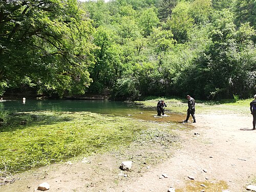
Two diveable entrances are documented: the Cabouy resurgence pool and the Pou Meyssen shaft about 800 m upstream (underground distance).
Yön bulmak için, navigasyon amaçlı değil. İçi boş noktalar yaklaşık konumdur.
Bu sayfadaki her bilgi, kaynağıyla birlikte (11)
| Bilgi | Durum | Kaynak |
|---|---|---|
| Sump 1 of the Ouysse network is 2,400 m long in total, with Cabouy as its main access point and Pou Meyssen about 800 m upstream. | Doğrulandı | [1] |
| About 1,950 m from Cabouy divers surface in a lake about 400 m long, beyond which sump 2 begins. | Doğrulandı | [1] |
| The first sump reaches low points of about 30 m near Cabouy and again beyond Pou Meyssen. | Doğrulandı | [1] |
| Re-lining dives ran from 11 November 2011 to 26 November 2014, laying nearly 2,400 m of new line and removing more than 3,000 m of old line. | Doğrulandı | [1] |
| Claude Touloumdjian made the 800 m traverse from Cabouy to Pou Meyssen, and a Franco-Swiss team passed the 1,200 m sump in the early 1980s.Historical summary given in the 2015 article without exact dates. | Bildirildi | [1] |
| The Pou Meyssen fiche links to a Project Baseline project for the Ouysse network and integrates surveys proposed by Torsten Schnitter (update of 29 November 2014). | Doğrulandı | [3] |
| Violent seasonal floods break guidelines in the Ouysse. | Doğrulandı | [1] |
| Divernet gives about 14 °C as the average cave water temperature in the Lot.Regional average, not a measurement for this cave. | Bildirildi | [4] |
| The FFS fiches and the Subaqua account do not state any permit or access rule for Cabouy or Pou Meyssen. | Bildirildi | [1] [2] [3] |
| The Cabouy resurgence is published at N 44°47'26" E 1°35'03" (FFS) and N 44.790496 E 1.584059 (The Cave To Be). | Doğrulandı | [2] [5] |
| The Cabouy resurgence is published at N 44°47'26" E 1°35'03". | Doğrulandı | [2] [5] |
Doğrulandı: incelediğimiz resmi veya birincil bir kaynak tarafından belirtilmiştir. Raporlandı: yalnızca ikincil bir kaynaktan. Kaynaklar çelişiyor: notta her iki versiyon da verilmiştir. Güncel olmayabilir: bulduğumuz en yeni kaynak eskidir.
Yukarıdaki kaynaklardan kendi ifadelerimizle yazıldı. Düzeltme bildir