洞窟システム
Sistema Taj Mahal
QRSS list entry reported by M. Nebenhaus, 08/2017. The QRSS long-cave list gives -23.8 m; the QRSS deep-cave list gives -24.4 m for the same 2017 report.
A 9,954 m underwater cave (QRSS, 2017 figure) entered at Cenote Tajma Ha south of Puerto Aventuras, used for cavern tours and as a designated cave training site, known for light beams and a dense halocline.
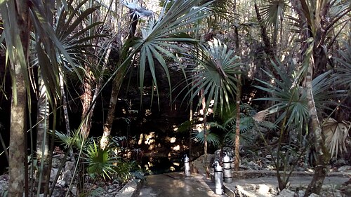
Sistema Taj Mahal is best known through Cenote Tajma Ha, which operators place about 5 km south of Puerto Aventuras. The cavern zone runs from the main entrance beneath an air-filled bat chamber to a smaller cenote divers call the Sugar Bowl, and in sunny weather light enters through openings in the ceiling. Deeper areas cross a halocline, where the mixing of fresh and salt water produces a shimmering, mirror-like layer.
QRSS lists eight cenotes for the system and a surveyed length of 9,954 m, last reported in 2017. Its permanent lines include the Jumna River, Sagrado and Mangrovia lines, parts of which CREER lists as approved places for training drills.
In February 2024 CREER advised that cavern tours should not be run at Tajma Ha because excavation at nearby Cenote Esmeralda had left excess sediment in the cavern zone, while cave diving remained open.
測量と探査の歴史
| 2017-08 | QRSS list entry updated to 9,954 m (M. Nebenhaus). [1] |
入口とダイブサイト
QRSS lists 8 cenotes. Cenote Tajma Ha is the operated dive entrance.
方向確認用であり、ナビゲーション用ではありません。白抜きのドットはおおよその位置を示しています。
このページのすべての情報とその出典 (7)
| 情報 | ステータス | 出典 |
|---|---|---|
| QRSS lists Sistema Taj Mahal at 9,954 m with 8 cenotes, reported by M. Nebenhaus in 08/2017.Newest figure found is from 2017. | 情報が古い可能性があります | [1] |
| QRSS gives a maximum depth of 23.8 m on its long-cave list and 24.4 m on its deep-cave list for Sistema Taj Mahal.Same 08/2017 report in both tables. | 情報源が一致しない | [1] [2] |
| Pro Dive International places Cenote Tajma Ha about 5 km south of Puerto Aventuras and 26 km south of Playa del Carmen.Operator description. | 報告済み | [5] |
| Pro Dive International describes the Tajma Ha cavern tour as passing a wide room beneath an air-filled bat cave to a smaller cenote called the Sugar Bowl, with haloclines in deeper areas. | 報告済み | [5] |
| CREER noted on 2024-02-27 that the Tajma Ha cavern line was unsafe because of excess sediment after the excavation of Cenote Esmeralda, marking cavern tours as not recommended while cave diving stayed open.Status may have changed since; page viewed 2026-10-14. | 確認済み | [3] |
| CREER rates Tajma Ha as Level 2 (Intermediate) for guided cavern diving. | 確認済み | [3] |
| CREER's 2020 training-site rules list the Jumna River line, Sagrado line, Mangrovia line and cavern zone at Tajma Ha among approved locations for zero-visibility or lost-line drills. | 確認済み | [4] |
確認済み:直接開いた公式または一次情報源による記載。報告ベース:二次情報源のみによるもの。情報が競合:注釈に両方のバージョンを記載。最新情報でない可能性あり:確認できた最新の情報源が古い。
上記のソースをもとに、独自の言葉でまとめています。 修正を報告する