동굴 시스템
Sistema Taj Mahal
QRSS list entry reported by M. Nebenhaus, 08/2017. The QRSS long-cave list gives -23.8 m; the QRSS deep-cave list gives -24.4 m for the same 2017 report.
A 9,954 m underwater cave (QRSS, 2017 figure) entered at Cenote Tajma Ha south of Puerto Aventuras, used for cavern tours and as a designated cave training site, known for light beams and a dense halocline.
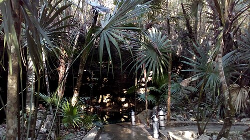
Sistema Taj Mahal is best known through Cenote Tajma Ha, which operators place about 5 km south of Puerto Aventuras. The cavern zone runs from the main entrance beneath an air-filled bat chamber to a smaller cenote divers call the Sugar Bowl, and in sunny weather light enters through openings in the ceiling. Deeper areas cross a halocline, where the mixing of fresh and salt water produces a shimmering, mirror-like layer.
QRSS lists eight cenotes for the system and a surveyed length of 9,954 m, last reported in 2017. Its permanent lines include the Jumna River, Sagrado and Mangrovia lines, parts of which CREER lists as approved places for training drills.
In February 2024 CREER advised that cavern tours should not be run at Tajma Ha because excavation at nearby Cenote Esmeralda had left excess sediment in the cavern zone, while cave diving remained open.
서베이 및 탐사 역사
| 2017-08 | QRSS list entry updated to 9,954 m (M. Nebenhaus). [1] |
입구 및 다이브 사이트
QRSS lists 8 cenotes. Cenote Tajma Ha is the operated dive entrance.
방향 파악용이며 내비게이션용이 아닙니다. 빈 점은 대략적인 위치입니다.
이 페이지의 모든 정보와 출처 (7)
| 정보 항목 | 상태 | 출처 |
|---|---|---|
| QRSS lists Sistema Taj Mahal at 9,954 m with 8 cenotes, reported by M. Nebenhaus in 08/2017.Newest figure found is from 2017. | 최신 정보가 아닐 수 있습니다 | [1] |
| QRSS gives a maximum depth of 23.8 m on its long-cave list and 24.4 m on its deep-cave list for Sistema Taj Mahal.Same 08/2017 report in both tables. | 출처 간 내용 불일치 | [1] [2] |
| Pro Dive International places Cenote Tajma Ha about 5 km south of Puerto Aventuras and 26 km south of Playa del Carmen.Operator description. | 보고됨 | [5] |
| Pro Dive International describes the Tajma Ha cavern tour as passing a wide room beneath an air-filled bat cave to a smaller cenote called the Sugar Bowl, with haloclines in deeper areas. | 보고됨 | [5] |
| CREER noted on 2024-02-27 that the Tajma Ha cavern line was unsafe because of excess sediment after the excavation of Cenote Esmeralda, marking cavern tours as not recommended while cave diving stayed open.Status may have changed since; page viewed 2026-10-14. | 확인됨 | [3] |
| CREER rates Tajma Ha as Level 2 (Intermediate) for guided cavern diving. | 확인됨 | [3] |
| CREER's 2020 training-site rules list the Jumna River line, Sagrado line, Mangrovia line and cavern zone at Tajma Ha among approved locations for zero-visibility or lost-line drills. | 확인됨 | [4] |
확인됨: 직접 열람한 공식 또는 1차 출처에서 명시된 정보입니다. 보고됨: 2차 출처에서만 확인된 정보입니다. 출처 간 상충: 비고에 두 가지 내용이 모두 기재되어 있습니다. 최신 정보가 아닐 수 있음: 확인된 가장 최근 출처가 오래된 경우입니다.
위의 출처를 바탕으로 자체적으로 작성했습니다. 수정 사항 제보