Yonaguni
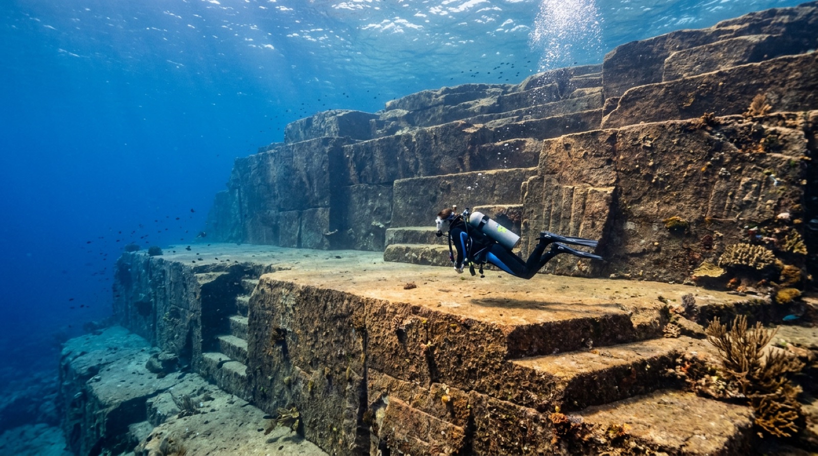
Yonaguni is Japan's westernmost island, a windswept speck nearer Taiwan than Okinawa, and it owes its dive fame to two things: schooling hammerheads in the cool months and the Yonaguni Monument, a massive stepped rock formation whose origin, natural or human-worked, has been argued over since its discovery in 1986. The Kuroshio Current keeps the water blue and the diving lively.
Why dive here
In winter, dive boats push out from Kubura harbor to the island's western tip, drop divers into open blue, and wait for shadows: scalloped hammerheads school off Irizaki in the cooler months, sometimes in tens, occasionally in walls of animals. It is drift diving with a purpose, raw and weather-dependent. The island's other draw sits in shallower water off the south coast. The Monument is a tiered mass of sandstone with flat terraces, sharp edges, and right angles, found in 1986 by local diver Kihachiro Aratake while scouting shark sites. One camp, led for years by marine geologist Masaaki Kimura, has argued the shapes were carved or modified by people; most geologists counter that the local sandstone naturally fractures along horizontal beds and vertical joints, producing steps without any help. Diving it settles nothing and improves the argument: the scale is genuinely strange in person. Around both headline acts run current-swept rocky reefs, swim-throughs, and very few other divers.
Month by month
Hammerhead season runs through the cool months, roughly December to March, which are also the windiest; trips depend on the northeast monsoon giving boats a workable window. Summer is calmer and warmer for the Monument and reefs, with typhoon risk from July to September.
| Month | Water | Visibility | What it's like |
|---|---|---|---|
| January●●●●● | 22–24 °C / 72–75 °F | 20–35 m | Hammerhead schools off Irizaki |
| February●●●●● | 21–23 °C / 70–73 °F | 20–35 m | Peak schooling; roughest crossings |
| March●●●●○ | 22–24 °C / 72–75 °F | 20–35 m | Late hammerheads as seas ease |
| April●●●○○ | 23–25 °C / 73–77 °F | 20–40 m | The Monument in gentler conditions |
| May●●●○○ | 25–27 °C / 77–81 °F | 20–40 m | Warm, quiet shoulder season |
| June●●●○○ | 27–29 °C / 81–84 °F | 20–40 m | Early-summer rains; few boats |
| July●●●○○ | 28–30 °C / 82–86 °F | 20–40 m | Typhoon watch begins |
| August●●●○○ | 28–30 °C / 82–86 °F | 20–40 m | Hot and storm-prone |
| September●●●○○ | 27–29 °C / 81–84 °F | 20–40 m | Typhoon swell risk |
| October●●●○○ | 26–28 °C / 79–82 °F | 20–40 m | Autumn stability returns |
| November●●●●○ | 24–26 °C / 75–79 °F | 20–35 m | First hammerhead reports |
| December●●●●● | 23–25 °C / 73–77 °F | 20–35 m | Schooling season opens |
Monthly figures confidence: Editorial estimate. Months without a row have no verified data — we would rather show a gap than invent one.
The dive sites (2)
| Site | Type | Depth | Level | Access | |
|---|---|---|---|---|---|
| Irizaki Schooling scalloped hammerheads, pure blue-water drift diving… | Blue water | 15–40 m | Advanced | Boat | |
| Yonaguni Monument The terraces and right angles themselves, the natural-versus-carved debate… | Reef | 5–26 m | Advanced | Boat |
Marine life you can plan around
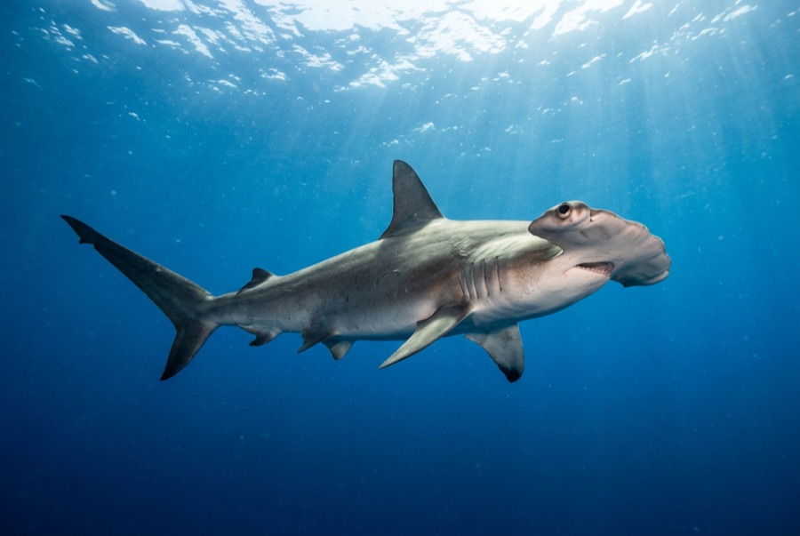
Scalloped hammerheads in schooling season, big pelagics along the drop-offs, turtles, and hardy current-loving reef fish. This is not a macro or coral-garden destination; the appeal is scale, blue water, and the strangeness of the Monument.
Getting there & staying
Getting there: Short flights connect Yonaguni with Naha and Ishigaki; a ferry also runs from Ishigaki and is notorious for rough crossings. On the island, rental cars or shop pickups cover the few kilometers between villages.
Where to stay: Accommodation is simple: small inns and dive lodges around Sonai and Kubura. Book diving and beds together, as capacity is limited.
Costs: Approximate conversion from yen for two boat dives with a local shop; gear rental and winter hammerhead trips can price higher.
Between dives: Cape lookouts at both ends of Japan's westernmost island, wild Yonaguni horses, awamori distilleries, and very dark night skies.
Safety & practicalities
Hazards: Strong Kuroshio-driven currents, surge over the Monument's terraces, blue-water drifts far from the reef, winter sea states that cancel days at a time, and minimal emergency infrastructure on a remote island.
Hammerhead dives are negative-entry drifts in open water: carry a surface marker, stay tight to the guide, and be honest about your experience before booking. Leave large margins; help is far away.
Nearest recompression: There is no hyperbaric chamber on Yonaguni; treatment means evacuation toward Okinawa's facilities. Emergencies go through 119 and DAN, and availability changes.