Puntos de buceo, temporadas y vida marina — investigados, cartografiados, planificados.
Menú
Destinos Puntos de buceo Vida marina Pecios Noticias
Planifica un viaje Planificador de viajes Cuándo bucear Calculadora de costes Comparativas Calendario de fauna marina Temperatura del agua Liveaboards Operadores y resorts Parques marinos Cámaras hiperbáricas Mapa mundial
Regiones Australia, Nueva Zelanda y Asia OrientalCaribe y Atlántico occidentalEuropa, Atlántico y MediterráneoOcéano Índico y África OrientalIslas del Pacífico y MicronesiaMar Rojo y Oriente MedioSudeste Asiático y el Triángulo del CoralLas Américas y el Pacífico Oriental Países
Aprender y herramientas Todas las guías Certificaciones Guías de equipo Vídeos Consulta los datos Agentes de IA API
Acerca de Quiénes somos Metodología Aviso legal Contacto
Tu vista
★ Guardado

Tus destinos, sitios y especies favoritos — guardados en este navegador.

API GATEWAY

Acceso JSON gratuito de solo lectura a los datos en caché del atlas.

Modo oscuro

🧭 Vista guiada
¿Nuevo en el buceo? ¿Profundidades, corrientes, niveles de certificación? Explicamos cada término mientras navegas, en un lenguaje claro. Los mismos datos, con la ayuda integrada.

⚡ Vista experta
Ya conoces la diferencia entre una pared y un drift dive. Solo los datos — claros, rápidos y concisos. Esta es la vista predeterminada.

Idioma de la interfaz
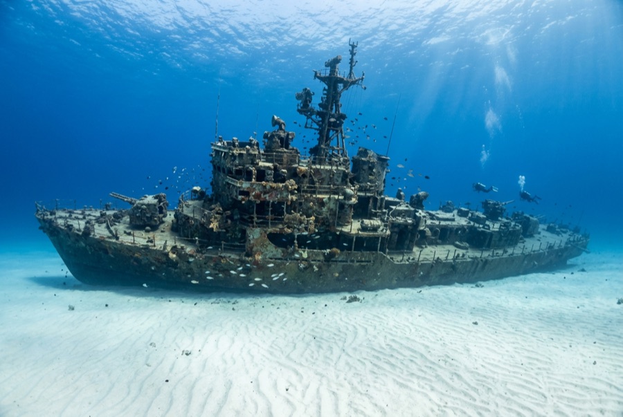
El Aguila — illustrative image

El Aguila

Coastal cargo freighter Hundido 1997 20–33 m Roatán
Ilustración generada por IA
Aquí se perdieron vidasNone (planned scuttling). Los operadores locales piden que el pecio se bucee con el respeto correspondiente.
Documentado
Profundidad hasta cubierta
20 m / 66 ft
Profundidad máxima
33 m / 108 ft
Construido / hundido
? / 1997
Longitud
70 m
Orientación
Upright Bow; Midships And Stern Broken Into Sections
Nivel
Intermediate
Mejores meses
Mar–Sep

La historia

'The Eagle' had already sunk once before divers ever saw her. The roughly 70-meter freighter went down at Utila while hauling cargo, was raised, and sat rusting in a Roatán harbor until the island's dive community bought the hull, cleaned it, and scuttled it in 1997 on the sand at about 33 meters outside the Sandy Bay reef line. A year later Hurricane Mitch — the storm that devastated Honduras — rolled across the site and snapped the ship into three sections, scattering the midships and leaving her looking far more like a genuine casualty than a placed attraction. Divers generally count that an improvement: the break opened the holds to light, created canyons of plating to weave through, and gave the wreck the pleasing chaos of a debris field anchored by an intact, upright bow. Her most famous residents are morays of unusual size and boldness — thick green morays that free-swim across the sand — along with garden eels, big amiable grouper and midnight parrotfish that follow divers from the nearby reef. She pairs naturally with the shallower reef wall for a two-level profile.

Cómo se hundió: Deliberately scuttled as an artificial reef off Sandy Bay, 1997.

Buceando aquí hoy

Condición: In three sections since Hurricane Mitch (1998); bow intact and upright, remainder broken but coherent

Penetración: Limited. Hurricane damage opened the structure; short, bright pass-throughs exist in the bow and holds, with nothing enclosed enough for long penetration. Acceder a cualquier entorno de penetración exige formación específica — como mínimo una certificación en pecios, y formación técnica en pecios para penetración completa.

Certificación recomendada: Advanced Open Water

Corriente: Mild · Visibilidad: 15–30 m

Vida marina: Oversized green morays hunt openly, garden eels ring the wreck, grouper and midnight parrotfish tag along, and eagle rays cross the sand flat.

Riesgos: Depth on the sand, sharp broken plating, and the usual temptation to overstay at 30 meters

Protección y legislación

Lies off Sandy Bay within Roatán's managed marine-reserve waters — park fees fund patrols and moorings

Ver

Desde los canales oficiales

Todos los vídeos →

Los vídeos son enlaces incrustados a los canales propios de sus creadores — no alojamos nada y acreditamos todo.

Fuentes: Roatán Marine Park ↗ · Datos verificados frente a las fuentes anteriores; los campos sin respaldo se marcan como aún no verificados.

Australia, Nueva Zelanda y Asia Oriental

Cairns & the Ribbon ReefsNingaloo ReefCoral Sea & Osprey ReefOkinawa & the Kerama IslandsPoor Knights IslandsTownsville & the YongalaGreen IslandIzu Peninsula

Caribe y Atlántico occidental

BonaireCozumelRiviera Maya & the CenotesBelize Barrier ReefGrand CaymanIsla Mujeres & CancúnRoatánTiger Beach & Grand Bahama

Europa, Atlántico y Mediterráneo

Malta & GozoSilfra & IcelandThe AzoresCanary IslandsLarnaca & the ZenobiaScapa FlowArctic NorwayMadeira

Océano Índico y África Oriental

North & South Malé AtollsAri AtollBaa Atoll & Hanifaru BayAliwal Shoal & UmkomaasMafia IslandMauritiusSeychellesSodwana Bay

Islas del Pacífico y Micronesia

PalauChuuk (Truk) LagoonFakaravaKona, HawaiʻiRangiroaTaveuni & Rainbow ReefBeqa Lagoon & Pacific HarbourEspiritu Santo

Mar Rojo y Oriente Medio

Sharm El Sheikh & Ras MohammedBrothers, Daedalus & St John'sDahabHurghada & El GounaMarsa Alam & the Deep SouthAqabaDaymaniyat IslandsMusandam Peninsula

Sudeste Asiático y el Triángulo del Coral

Bali & Nusa PenidaKomodoRaja AmpatSipadan & MabulAnilaoCoronKoh TaoLembeh Strait

Las Américas y el Pacífico Oriental

Galápagos IslandsCocos IslandFlorida KeysSea of Cortez & Cabo PulmoSocorro & the RevillagigedosBritish ColumbiaCalifornia Channel IslandsCosta Rica Pacific Coast