Situs selam, musim, dan kehidupan laut — diteliti, dipetakan, direncanakan.
Menu
Destinasi Lokasi Selam Kehidupan Laut Bangkai kapal Berita
Rencanakan perjalanan Perencana trip Kapan waktu terbaik menyelam Kalkulator biaya Perbandingan Kalender kehidupan laut Suhu air Liveaboard Operator & resor Taman laut Ruang hiperbarik Peta dunia
Wilayah Australia, Selandia Baru & Asia TimurKaribia & Atlantik BaratEropa, Atlantik & MediteraniaSamudra Hindia & Afrika TimurKepulauan Pasifik & MikronesiaLaut Merah & Timur TengahAsia Tenggara & Segitiga Terumbu KarangAmerika & Pasifik Timur Negara
Pelajari & Alat Semua panduan Sertifikasi Panduan perlengkapan Video Tanya Data Agen AI API
Tentang Tentang kami Metodologi Penafian Kontak
Tampilan kamu
★ Tersimpan

Destinasi, lokasi selam, dan spesies favorit yang kamu bintangi — tersimpan di browser ini.

API GATEWAY

Akses JSON gratis hanya-baca ke data cache atlas.

Mode gelap

🧭 Tampilan Terpandu
Baru mengenal menyelam — kedalaman, arus, level sertifikasi? Kami menjelaskan setiap istilah saat kamu menjelajah, dalam bahasa yang mudah dipahami. Data yang sama, lengkap dengan panduan bawaan.

⚡ Tampilan Ahli
Kamu sudah tahu perbedaan antara wall dive dan drift dive. Cukup datanya — bersih, cepat, dan ringkas. Ini adalah tampilan default.

Bahasa antarmuka
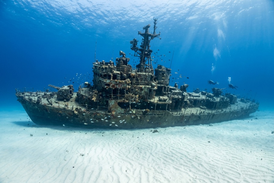
El Aguila — illustrative image

El Aguila

Coastal cargo freighter Ditenggelamkan 1997 20–33 m Roatán
Ilustrasi hasil AI
Ada nyawa yang melayang di siniNone (planned scuttling). Operator lokal meminta agar bangkai kapal ini diselami dengan rasa hormat yang sepadan.
Terdokumentasi
Kedalaman ke dek
20 m / 66 ft
Kedalaman maksimum
33 m / 108 ft
Dibangun / ditenggelamkan
? / 1997
Panjang
70 m
Orientasi
Upright Bow; Midships And Stern Broken Into Sections
Level
Intermediate
Bulan-bulan terbaik
Mar–Sep

Kisahnya

'The Eagle' had already sunk once before divers ever saw her. The roughly 70-meter freighter went down at Utila while hauling cargo, was raised, and sat rusting in a Roatán harbor until the island's dive community bought the hull, cleaned it, and scuttled it in 1997 on the sand at about 33 meters outside the Sandy Bay reef line. A year later Hurricane Mitch — the storm that devastated Honduras — rolled across the site and snapped the ship into three sections, scattering the midships and leaving her looking far more like a genuine casualty than a placed attraction. Divers generally count that an improvement: the break opened the holds to light, created canyons of plating to weave through, and gave the wreck the pleasing chaos of a debris field anchored by an intact, upright bow. Her most famous residents are morays of unusual size and boldness — thick green morays that free-swim across the sand — along with garden eels, big amiable grouper and midnight parrotfish that follow divers from the nearby reef. She pairs naturally with the shallower reef wall for a two-level profile.

Bagaimana kapal ini tenggelam: Deliberately scuttled as an artificial reef off Sandy Bay, 1997.

Menyelaminya hari ini

Kondisi: In three sections since Hurricane Mitch (1998); bow intact and upright, remainder broken but coherent

Penetrasi: Limited. Hurricane damage opened the structure; short, bright pass-throughs exist in the bow and holds, with nothing enclosed enough for long penetration. Memasuki area overhead apa pun memerlukan pelatihan khusus — minimal sertifikasi wreck, dan pelatihan wreck teknis untuk penetrasi penuh.

Sertifikasi yang disarankan: Advanced Open Water

Arus: Mild · Visibilitas: 15–30 m

Kehidupan laut: Oversized green morays hunt openly, garden eels ring the wreck, grouper and midnight parrotfish tag along, and eagle rays cross the sand flat.

Bahaya: Depth on the sand, sharp broken plating, and the usual temptation to overstay at 30 meters

Perlindungan & hukum

Lies off Sandy Bay within Roatán's managed marine-reserve waters — park fees fund patrols and moorings

Tonton

Dari saluran resmi

Semua video →

Video adalah tautan sematan ke kanal milik kreatornya sendiri — kami tidak meng-host apa pun dan selalu mencantumkan kredit.

Sumber: Roatán Marine Park ↗ · Fakta diverifikasi terhadap sumber-sumber di atas; kolom yang belum didukung data diberi label belum diverifikasi.

Australia, Selandia Baru & Asia Timur

Cairns & the Ribbon ReefsNingaloo ReefCoral Sea & Osprey ReefOkinawa & the Kerama IslandsPoor Knights IslandsTownsville & the YongalaGreen IslandIzu Peninsula

Karibia & Atlantik Barat

BonaireCozumelRiviera Maya & the CenotesBelize Barrier ReefGrand CaymanIsla Mujeres & CancúnRoatánTiger Beach & Grand Bahama

Eropa, Atlantik & Mediterania

Malta & GozoSilfra & IcelandThe AzoresCanary IslandsLarnaca & the ZenobiaScapa FlowArctic NorwayMadeira

Samudra Hindia & Afrika Timur

North & South Malé AtollsAri AtollBaa Atoll & Hanifaru BayAliwal Shoal & UmkomaasMafia IslandMauritiusSeychellesSodwana Bay

Kepulauan Pasifik & Mikronesia

PalauChuuk (Truk) LagoonFakaravaKona, HawaiʻiRangiroaTaveuni & Rainbow ReefBeqa Lagoon & Pacific HarbourEspiritu Santo

Laut Merah & Timur Tengah

Sharm El Sheikh & Ras MohammedBrothers, Daedalus & St John'sDahabHurghada & El GounaMarsa Alam & the Deep SouthAqabaDaymaniyat IslandsMusandam Peninsula

Asia Tenggara & Segitiga Terumbu Karang

Bali & Nusa PenidaKomodoRaja AmpatSipadan & MabulAnilaoCoronKoh TaoLembeh Strait

Amerika & Pasifik Timur

Galápagos IslandsCocos IslandFlorida KeysSea of Cortez & Cabo PulmoSocorro & the RevillagigedosBritish ColumbiaCalifornia Channel IslandsCosta Rica Pacific Coast