Siti di immersione, stagioni e fauna marina — ricercati, mappati, pianificati.
Menu
Destinazioni Siti di immersione Vita marina Relitti Notizie
Pianifica un viaggio Pianificatore di viaggi Quando immergersi Calcolatore dei costi Confronti Calendario della fauna marina Temperatura dell'acqua Liveaboard Operatori & resort Parchi marini Camere iperbariche Mappa del mondo
Regioni Australia, Nuova Zelanda e Asia OrientaleCaraibi e Atlantico occidentaleEuropa, Atlantico e MediterraneoOceano Indiano e Africa OrientaleIsole del Pacifico & MicronesiaMar Rosso & Medio OrienteAsia meridionale e Triangolo dei CoralliLe Americhe e il Pacifico orientale Paesi
Impara e strumenti Tutte le guide Brevetti Guide all'attrezzatura Video Interroga i dati AI Agent API
Informazioni Chi siamo Metodologia Disclaimer Contatti
La tua vista
★ Salvato

Le tue destinazioni, siti e specie preferiti — salvati in questo browser.

API GATEWAY

Accesso JSON gratuito in sola lettura ai dati in cache dell'atlante.

Modalità scura

🧭 Visualizzazione Guidata
Sei nuovo alle immersioni — profondità, correnti, livelli di brevetto? Spieghiamo ogni termine mentre navighi, in modo semplice e chiaro. Gli stessi dati, con il supporto integrato.

⚡ Visualizzazione Esperta
Conosci già la differenza tra una parete e una drift dive. Solo i dati — chiari, rapidi e compatti. Questa è la visualizzazione predefinita.

Lingua dell'interfaccia
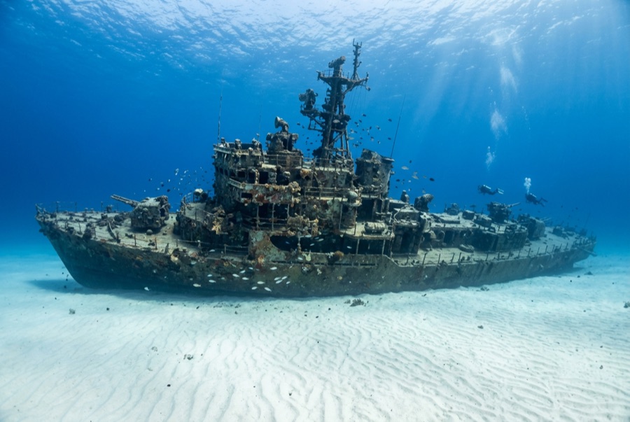
El Aguila — illustrative image

El Aguila

Coastal cargo freighter Affondata 1997 20–33 m Roatán
Illustrazione generata dall'AI
Qui si sono perse delle viteNone (planned scuttling). Gli operatori locali chiedono che il relitto venga visitato con il dovuto rispetto.
Documentato
Profondità al ponte
20 m / 66 ft
Profondità massima
33 m / 108 ft
Costruito / affondato
? / 1997
Lunghezza
70 m
Orientamento
Upright Bow; Midships And Stern Broken Into Sections
Livello
Intermediate
Mesi migliori
Mar–Sep

La storia

'The Eagle' had already sunk once before divers ever saw her. The roughly 70-meter freighter went down at Utila while hauling cargo, was raised, and sat rusting in a Roatán harbor until the island's dive community bought the hull, cleaned it, and scuttled it in 1997 on the sand at about 33 meters outside the Sandy Bay reef line. A year later Hurricane Mitch — the storm that devastated Honduras — rolled across the site and snapped the ship into three sections, scattering the midships and leaving her looking far more like a genuine casualty than a placed attraction. Divers generally count that an improvement: the break opened the holds to light, created canyons of plating to weave through, and gave the wreck the pleasing chaos of a debris field anchored by an intact, upright bow. Her most famous residents are morays of unusual size and boldness — thick green morays that free-swim across the sand — along with garden eels, big amiable grouper and midnight parrotfish that follow divers from the nearby reef. She pairs naturally with the shallower reef wall for a two-level profile.

Come è affondata: Deliberately scuttled as an artificial reef off Sandy Bay, 1997.

Immersioni su di essa oggi

Condizione: In three sections since Hurricane Mitch (1998); bow intact and upright, remainder broken but coherent

Penetrazione: Limited. Hurricane damage opened the structure; short, bright pass-throughs exist in the bow and holds, with nothing enclosed enough for long penetration. Entrare in qualsiasi ambiente overhead richiede una formazione specifica — come minimo una certificazione wreck, e una formazione tecnica wreck per la penetrazione completa.

Certificazione consigliata: Advanced Open Water

Corrente: Mild · Visibilità: 15–30 m

Vita marina: Oversized green morays hunt openly, garden eels ring the wreck, grouper and midnight parrotfish tag along, and eagle rays cross the sand flat.

Pericoli: Depth on the sand, sharp broken plating, and the usual temptation to overstay at 30 meters

Tutela & normativa

Lies off Sandy Bay within Roatán's managed marine-reserve waters — park fees fund patrols and moorings

Guarda

Dai canali ufficiali

Tutti i video →

I video sono link incorporati ai canali dei rispettivi autori — non ospitiamo nulla e diamo sempre credito a tutti.

Fonti: Roatán Marine Park ↗ · Dati verificati rispetto alle fonti indicate; i campi privi di riscontro sono contrassegnati come non ancora verificati.

Australia, Nuova Zelanda e Asia Orientale

Cairns & the Ribbon ReefsNingaloo ReefCoral Sea & Osprey ReefOkinawa & the Kerama IslandsPoor Knights IslandsTownsville & the YongalaGreen IslandIzu Peninsula

Caraibi e Atlantico occidentale

BonaireCozumelRiviera Maya & the CenotesBelize Barrier ReefGrand CaymanIsla Mujeres & CancúnRoatánTiger Beach & Grand Bahama

Europa, Atlantico e Mediterraneo

Malta & GozoSilfra & IcelandThe AzoresCanary IslandsLarnaca & the ZenobiaScapa FlowArctic NorwayMadeira

Oceano Indiano e Africa Orientale

North & South Malé AtollsAri AtollBaa Atoll & Hanifaru BayAliwal Shoal & UmkomaasMafia IslandMauritiusSeychellesSodwana Bay

Isole del Pacifico & Micronesia

PalauChuuk (Truk) LagoonFakaravaKona, HawaiʻiRangiroaTaveuni & Rainbow ReefBeqa Lagoon & Pacific HarbourEspiritu Santo

Mar Rosso & Medio Oriente

Sharm El Sheikh & Ras MohammedBrothers, Daedalus & St John'sDahabHurghada & El GounaMarsa Alam & the Deep SouthAqabaDaymaniyat IslandsMusandam Peninsula

Asia meridionale e Triangolo dei Coralli

Bali & Nusa PenidaKomodoRaja AmpatSipadan & MabulAnilaoCoronKoh TaoLembeh Strait

Le Americhe e il Pacifico orientale

Galápagos IslandsCocos IslandFlorida KeysSea of Cortez & Cabo PulmoSocorro & the RevillagigedosBritish ColumbiaCalifornia Channel IslandsCosta Rica Pacific Coast