Duiksites, seizoenen en zeeleven — onderzocht, in kaart gebracht, gepland.
Menu
Bestemmingen Duiklocaties Zeeleven Wrakken Nieuws
Plan een reis Reisplanner Wanneer duiken Kostencalculator Vergelijkingen Zeeleven-kalender Watertemperatuur Liveaboards Operators & resorts Mariene parken Hyperbare kamers Wereldkaart
Regio's Australië, Nieuw-Zeeland & Oost-AziëCaribisch gebied & westelijke Atlantische OceaanEuropa, Atlantische Oceaan & Middellandse ZeeIndische Oceaan & Oost-AfrikaPacifische eilanden & MicronesiëRode Zee & Midden-OostenZuidoost-Azië & Coral TriangleDe Amerika's & Oost-Stille Oceaan Landen
Leren & Tools Alle gidsen Brevetten Uitrustingsgidsen Video's Vraag de data AI-agents API
Over Over ons Methodologie Disclaimer Contact
Jouw weergave
★ Opgeslagen

Jouw favoriete bestemmingen, duiklocaties en soorten — opgeslagen in deze browser.

API GATEWAY

Gratis alleen-lezen JSON-toegang tot de gecachede data van de atlas.

Donkere modus

🧭 Begeleide weergave
Nieuw met duiken — dieptes, stromingen, brevetniveaus? We leggen elke term uit terwijl je bladert, in gewone taal. Dezelfde gegevens, met ingebouwde uitleg.

⚡ Expertweergave
Je weet het verschil tussen een wand en een drift dive al. Alleen de data — overzichtelijk, snel en compact. Dit is de standaardweergave.

Interfacetaal
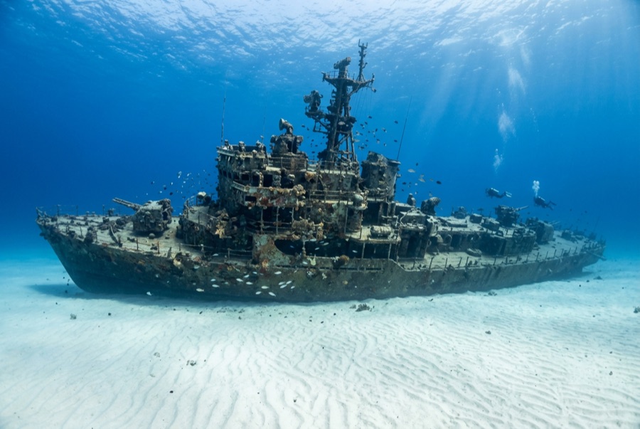
El Aguila — illustrative image

El Aguila

Coastal cargo freighter Gezonken 1997 20–33 m Roatán
AI-gegenereerde illustratie
Er zijn levens verloren gegaanNone (planned scuttling). Lokale operators verzoeken het wrak met gepast respect te duiken.
Gedocumenteerd
Diepte tot dek
20 m / 66 ft
Maximale diepte
33 m / 108 ft
Gebouwd / gezonken
? / 1997
Lengte
70 m
Oriëntatie
Upright Bow; Midships And Stern Broken Into Sections
Niveau
Intermediate
Beste maanden
Mar–Sep

Het verhaal

'The Eagle' had already sunk once before divers ever saw her. The roughly 70-meter freighter went down at Utila while hauling cargo, was raised, and sat rusting in a Roatán harbor until the island's dive community bought the hull, cleaned it, and scuttled it in 1997 on the sand at about 33 meters outside the Sandy Bay reef line. A year later Hurricane Mitch — the storm that devastated Honduras — rolled across the site and snapped the ship into three sections, scattering the midships and leaving her looking far more like a genuine casualty than a placed attraction. Divers generally count that an improvement: the break opened the holds to light, created canyons of plating to weave through, and gave the wreck the pleasing chaos of a debris field anchored by an intact, upright bow. Her most famous residents are morays of unusual size and boldness — thick green morays that free-swim across the sand — along with garden eels, big amiable grouper and midnight parrotfish that follow divers from the nearby reef. She pairs naturally with the shallower reef wall for a two-level profile.

Hoe ze zonk: Deliberately scuttled as an artificial reef off Sandy Bay, 1997.

Duik er vandaag in

Conditie: In three sections since Hurricane Mitch (1998); bow intact and upright, remainder broken but coherent

Penetratieduiken: Limited. Hurricane damage opened the structure; short, bright pass-throughs exist in the bow and holds, with nothing enclosed enough for long penetration. Het betreden van elke overhead-omgeving vereist specifieke training — minimaal een wrakduikcertificaat, technische wraktraining voor volledige penetratie.

Aanbevolen certificering: Advanced Open Water

Stroming: Mild · Zicht: 15–30 m

Zeeleven: Oversized green morays hunt openly, garden eels ring the wreck, grouper and midnight parrotfish tag along, and eagle rays cross the sand flat.

Gevaren: Depth on the sand, sharp broken plating, and the usual temptation to overstay at 30 meters

Bescherming & wetgeving

Lies off Sandy Bay within Roatán's managed marine-reserve waters — park fees fund patrols and moorings

Bekijk

Via de officiële kanalen

Alle video's →

Video's zijn ingesloten links naar de kanalen van de makers zelf — wij hosten niets en vermelden altijd de bron.

Bronnen: Roatán Marine Park ↗ · Feiten geverifieerd aan de hand van bovenstaande bronnen; velden zonder onderbouwing zijn aangemerkt als nog niet geverifieerd.

Australië, Nieuw-Zeeland & Oost-Azië

Cairns & the Ribbon ReefsNingaloo ReefCoral Sea & Osprey ReefOkinawa & the Kerama IslandsPoor Knights IslandsTownsville & the YongalaGreen IslandIzu Peninsula

Caribisch gebied & westelijke Atlantische Oceaan

BonaireCozumelRiviera Maya & the CenotesBelize Barrier ReefGrand CaymanIsla Mujeres & CancúnRoatánTiger Beach & Grand Bahama

Europa, Atlantische Oceaan & Middellandse Zee

Malta & GozoSilfra & IcelandThe AzoresCanary IslandsLarnaca & the ZenobiaScapa FlowArctic NorwayMadeira

Indische Oceaan & Oost-Afrika

North & South Malé AtollsAri AtollBaa Atoll & Hanifaru BayAliwal Shoal & UmkomaasMafia IslandMauritiusSeychellesSodwana Bay

Pacifische eilanden & Micronesië

PalauChuuk (Truk) LagoonFakaravaKona, HawaiʻiRangiroaTaveuni & Rainbow ReefBeqa Lagoon & Pacific HarbourEspiritu Santo

Rode Zee & Midden-Oosten

Sharm El Sheikh & Ras MohammedBrothers, Daedalus & St John'sDahabHurghada & El GounaMarsa Alam & the Deep SouthAqabaDaymaniyat IslandsMusandam Peninsula

Zuidoost-Azië & Coral Triangle

Bali & Nusa PenidaKomodoRaja AmpatSipadan & MabulAnilaoCoronKoh TaoLembeh Strait

De Amerika's & Oost-Stille Oceaan

Galápagos IslandsCocos IslandFlorida KeysSea of Cortez & Cabo PulmoSocorro & the RevillagigedosBritish ColumbiaCalifornia Channel IslandsCosta Rica Pacific Coast