Pontos de mergulho, épocas e vida marinha — pesquisados, mapeados, planeados.
Menu
Destinos Pontos de Mergulho Vida Marinha Naufrágios Notícias
Planejar uma viagem Planejador de viagem Quando mergulhar Calculadora de custos Comparações Calendário de vida marinha Temperatura da água Liveaboards Operadores & resorts Parques marinhos Câmaras hiperbáricas Mapa mundial
Regiões Austrália, Nova Zelândia e Ásia OrientalCaribe e Atlântico OcidentalEuropa, Atlântico & MediterrâneoOceano Índico e África OrientalIlhas do Pacífico & MicronésiaMar Vermelho & Médio OrienteSudeste Asiático e Triângulo de CoralAs Américas e o Pacífico Oriental Países
Aprender e Ferramentas Todos os guias Certificações Guias de equipamento Vídeos Consulte os Dados Agentes de IA API
Sobre Sobre nós Metodologia Aviso legal Contato
A sua vista
★ Guardado

Os seus destinos, sítios de mergulho e espécies favoritos — guardados neste browser.

API GATEWAY

Acesso JSON gratuito e só de leitura aos dados em cache do atlas.

Modo escuro

🧭 Vista Guiada
Novo no mergulho — profundidades, correntes, níveis de certificação? Explicamos cada termo enquanto navega, em linguagem simples. Os mesmos dados, com a ajuda integrada.

⚡ Vista de Especialista
Já sabe a diferença entre uma parede e um drift dive. Apenas os dados — claros, rápidos e compactos. Esta é a vista predefinida.

Idioma da interface
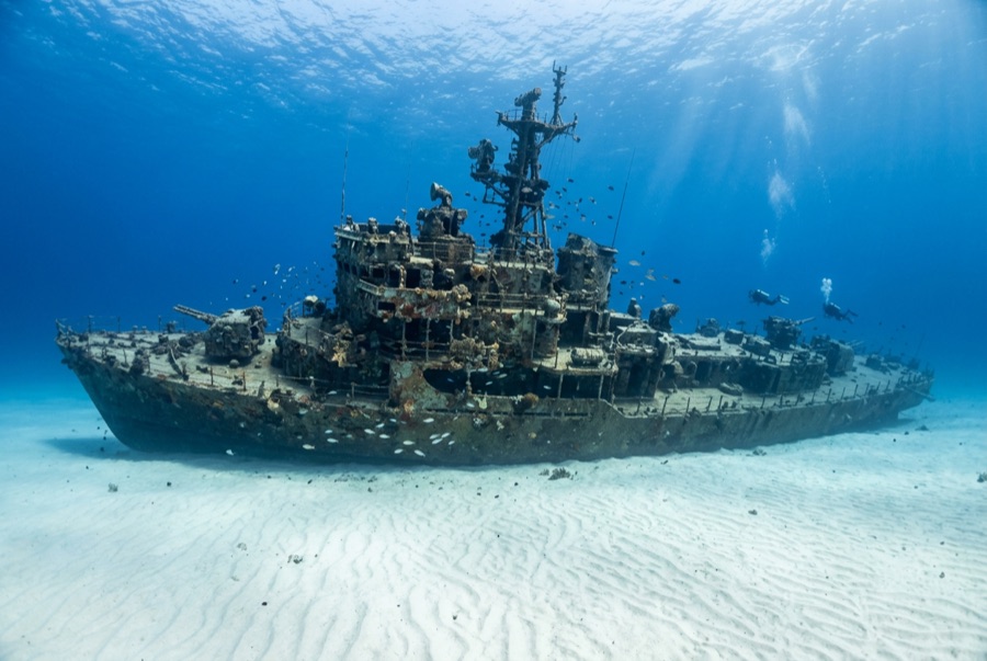
El Aguila — illustrative image

El Aguila

Coastal cargo freighter Afundado 1997 20–33 m Roatán
Ilustração gerada por IA
Houve vidas perdidas aquiNone (planned scuttling). Os operadores locais pedem que o naufrágio seja mergulhado com o respeito correspondente.
Documentado
Profundidade até o convés
20 m / 66 ft
Profundidade máxima
33 m / 108 ft
Construído / afundado
? / 1997
Comprimento
70 m
Orientação
Upright Bow; Midships And Stern Broken Into Sections
Nível
Intermediate
Melhores meses
Mar–Sep

A história

'The Eagle' had already sunk once before divers ever saw her. The roughly 70-meter freighter went down at Utila while hauling cargo, was raised, and sat rusting in a Roatán harbor until the island's dive community bought the hull, cleaned it, and scuttled it in 1997 on the sand at about 33 meters outside the Sandy Bay reef line. A year later Hurricane Mitch — the storm that devastated Honduras — rolled across the site and snapped the ship into three sections, scattering the midships and leaving her looking far more like a genuine casualty than a placed attraction. Divers generally count that an improvement: the break opened the holds to light, created canyons of plating to weave through, and gave the wreck the pleasing chaos of a debris field anchored by an intact, upright bow. Her most famous residents are morays of unusual size and boldness — thick green morays that free-swim across the sand — along with garden eels, big amiable grouper and midnight parrotfish that follow divers from the nearby reef. She pairs naturally with the shallower reef wall for a two-level profile.

Como afundou: Deliberately scuttled as an artificial reef off Sandy Bay, 1997.

A mergulhar nela hoje

Condição: In three sections since Hurricane Mitch (1998); bow intact and upright, remainder broken but coherent

Penetração: Limited. Hurricane damage opened the structure; short, bright pass-throughs exist in the bow and holds, with nothing enclosed enough for long penetration. Entrar em qualquer ambiente fechado requer formação específica — no mínimo uma certificação de mergulho em naufrágios, e formação técnica em naufrágios para penetração total.

Certificação recomendada: Advanced Open Water

Corrente: Mild · Visibilidade: 15–30 m

Vida marinha: Oversized green morays hunt openly, garden eels ring the wreck, grouper and midnight parrotfish tag along, and eagle rays cross the sand flat.

Perigos: Depth on the sand, sharp broken plating, and the usual temptation to overstay at 30 meters

Proteção & legislação

Lies off Sandy Bay within Roatán's managed marine-reserve waters — park fees fund patrols and moorings

Assista

Dos canais oficiais

Todos os vídeos →

Os vídeos são links incorporados dos próprios canais dos criadores — não hospedamos nada e creditamos tudo.

Fontes: Roatán Marine Park ↗ · Factos verificados em relação às fontes acima; os campos sem suporte estão assinalados como não verificado ainda.

Austrália, Nova Zelândia e Ásia Oriental

Cairns & the Ribbon ReefsNingaloo ReefCoral Sea & Osprey ReefOkinawa & the Kerama IslandsPoor Knights IslandsTownsville & the YongalaGreen IslandIzu Peninsula

Caribe e Atlântico Ocidental

BonaireCozumelRiviera Maya & the CenotesBelize Barrier ReefGrand CaymanIsla Mujeres & CancúnRoatánTiger Beach & Grand Bahama

Europa, Atlântico & Mediterrâneo

Malta & GozoSilfra & IcelandThe AzoresCanary IslandsLarnaca & the ZenobiaScapa FlowArctic NorwayMadeira

Oceano Índico e África Oriental

North & South Malé AtollsAri AtollBaa Atoll & Hanifaru BayAliwal Shoal & UmkomaasMafia IslandMauritiusSeychellesSodwana Bay

Ilhas do Pacífico & Micronésia

PalauChuuk (Truk) LagoonFakaravaKona, HawaiʻiRangiroaTaveuni & Rainbow ReefBeqa Lagoon & Pacific HarbourEspiritu Santo

Mar Vermelho & Médio Oriente

Sharm El Sheikh & Ras MohammedBrothers, Daedalus & St John'sDahabHurghada & El GounaMarsa Alam & the Deep SouthAqabaDaymaniyat IslandsMusandam Peninsula

Sudeste Asiático e Triângulo de Coral

Bali & Nusa PenidaKomodoRaja AmpatSipadan & MabulAnilaoCoronKoh TaoLembeh Strait

As Américas e o Pacífico Oriental

Galápagos IslandsCocos IslandFlorida KeysSea of Cortez & Cabo PulmoSocorro & the RevillagigedosBritish ColumbiaCalifornia Channel IslandsCosta Rica Pacific Coast