Tauchplätze, Saisons und Meereslebewesen – recherchiert, kartiert, geplant.
Menü
Reiseziele Tauchplätze Meeresleben Wracks News
Eine Reise planen Tauchtrip-Planer Wann tauchen Kostenrechner Vergleiche Meereslebewesen-Kalender Wassertemperatur Liveaboards Tauchbetriebe & Resorts Meeresschutzgebiete Druckkammern Weltkarte
Regionen Australien, Neuseeland & OstasienKaribik & WestatlantikEuropa, Atlantik & MittelmeerIndischer Ozean & OstafrikaPazifikinseln & MikronesienRotes Meer & Naher OstenSüdostasien & Korallen-DreieckAmerika & Östlicher Pazifik Länder
Lernen & Tools Alle Guides Zertifizierungen Ausrüstungsratgeber Videos Daten abfragen KI-Agenten API
Über uns Über uns Methodik Haftungsausschluss Kontakt
Deine Ansicht
★ Gespeichert

Deine gespeicherten Reiseziele, Tauchplätze und Tierarten — im Browser gespeichert.

API-GATEWAY

Kostenloser, schreibgeschützter JSON-Zugriff auf die gecachten Daten des Atlas.

Dunkelmodus

🧭 Geführte Ansicht
Neu beim Tauchen — Tiefen, Strömungen, Zertifizierungsstufen? Wir erklären jeden Begriff beim Stöbern in verständlicher Sprache. Dieselben Daten, mit integrierter Hilfe.

⚡ Expertenansicht
Du kennst den Unterschied zwischen einem Wall und einem Drift Dive. Nur die Daten – klar, schnell und kompakt. Das ist die Standardansicht.

Oberflächensprache
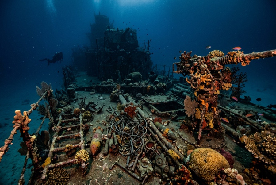
Hirokawa Maru (Bonegi I) — illustrative image

Hirokawa Maru (Bonegi I)

Japanese army transport ship Gesunken 1942 3–55 m Solomon Islands
KI-generierte Illustration
Dokumentiert
Tiefe zum Wrackdeck
3 m / 10 ft
Maximale Tiefe
55 m / 180 ft
Gebaut / versenkt
? / 1942
Tonnage
6,872 GRT
Orientierung
Bow Inshore At The Beach, Stern Running Down The Slope
Level
Intermediate
Beste Monate
May–Oct

Die Geschichte dahinter

By November 1942 the fight for Guadalcanal had become a contest of supply, and Japan was losing it. In the aftermath of the naval battles of 12–15 November, Rear Admiral Tanaka's last four surviving transports abandoned any hope of unloading offshore and simply drove themselves onto the beaches west of the American lines to disgorge troops and rice directly. The Hirokawa Maru went ashore near the mouth of the Bonegi River on 15 November and was wrecked where she lay through the day by aircraft, field artillery, and destroyer gunfire before most of her cargo could be landed. Her bow has sat in the surf line ever since — snorkelers float over it — while the rest of the hull runs down the dark volcanic sand into deep water. Known to divers simply as Bonegi I, with her consort Kinugawa Maru (Bonegi II) beached minutes away, she is Guadalcanal's classic shore dive and a blunt monument to the campaign's arithmetic.

Wie sie sank: Deliberately run ashore at Guadalcanal on 15 November 1942 to land troops and supplies, then destroyed by US aircraft, artillery, and naval gunfire.

Heute dort tauchen

Bedingung: Progressively broken from decades of surf at the shallow end; the deeper structure holds together better in still water.

Wrackinnenraum-Tauchen: Limited. Open breaks in the hull allow short pass-throughs in the shallow and mid sections; the deep stern is dark, silty, and for experienced divers only. Das Betreten von Überkopf-Umgebungen erfordert eine spezifische Ausbildung – mindestens ein Wrack-Zertifikat, für die vollständige Penetration eine technische Wrack-Ausbildung.

Empfohlene Zertifizierung: Open Water for the shallows; Advanced Open Water beyond the mid-hull

Strömung: Mild · Sichtweite: 8–20 m

Meeresleben: Corals and clams armor the shallow wreckage, anthias and damsels swarm the framework, and eagle rays and reef sharks appear off the deep end.

Gefahren: Surge and surf at entry, sharp plating in the shallows, and a seductive slope that keeps offering another five meters of depth.

Schutz & Recht

Lives were lost aboard and around her during the beaching and bombardment; she is dived respectfully. Solomon Islands wartime relics are protected — nothing may be recovered.

Wartime relics are protected under Solomon Islands law; take photographs only.

Ansehen

Aus den offiziellen Kanälen

Alle Videos →

Videos sind eingebettete Links zu den Kanälen der jeweiligen Ersteller – wir hosten nichts und geben für alles die Quelle an.

Quellen: U.S. Navy ↗PacificWrecks.com ↗ · Fakten wurden anhand der oben genannten Quellen verifiziert; Felder ohne Quellenbeleg sind als noch nicht verifiziert gekennzeichnet.

Australien, Neuseeland & Ostasien

Cairns & the Ribbon ReefsNingaloo ReefCoral Sea & Osprey ReefOkinawa & the Kerama IslandsPoor Knights IslandsTownsville & the YongalaGreen IslandIzu Peninsula

Karibik & Westatlantik

BonaireCozumelRiviera Maya & the CenotesBelize Barrier ReefGrand CaymanIsla Mujeres & CancúnRoatánTiger Beach & Grand Bahama

Europa, Atlantik & Mittelmeer

Malta & GozoSilfra & IcelandThe AzoresCanary IslandsLarnaca & the ZenobiaScapa FlowArctic NorwayMadeira

Indischer Ozean & Ostafrika

North & South Malé AtollsAri AtollBaa Atoll & Hanifaru BayAliwal Shoal & UmkomaasMafia IslandMauritiusSeychellesSodwana Bay

Pazifikinseln & Mikronesien

PalauChuuk (Truk) LagoonFakaravaKona, HawaiʻiRangiroaTaveuni & Rainbow ReefBeqa Lagoon & Pacific HarbourEspiritu Santo

Rotes Meer & Naher Osten

Sharm El Sheikh & Ras MohammedBrothers, Daedalus & St John'sDahabHurghada & El GounaMarsa Alam & the Deep SouthAqabaDaymaniyat IslandsMusandam Peninsula

Südostasien & Korallen-Dreieck

Bali & Nusa PenidaKomodoRaja AmpatSipadan & MabulAnilaoCoronKoh TaoLembeh Strait

Amerika & Östlicher Pazifik

Galápagos IslandsCocos IslandFlorida KeysSea of Cortez & Cabo PulmoSocorro & the RevillagigedosBritish ColumbiaCalifornia Channel IslandsCosta Rica Pacific Coast