Temukan tempat menyelam, waktu terbaik untuk pergi, dan apa yang bisa Anda lihat.

Temukan tempat menyelam, waktu terbaik untuk pergi, dan apa yang bisa Anda lihat.
★
Menu
Destinasi Lokasi Selam Kehidupan Laut Bangkai kapal Berita
Rencanakan perjalanan Perencana trip Kapan waktu terbaik menyelam Kalkulator biaya Perbandingan Kalender kehidupan laut Suhu air Liveaboard Operator & resor Taman laut Ruang hiperbarik Peta dunia
Selam gua Semua cave diving Destinasi & Lokasi Selam Sistem Cave & Peta Pelatihan & Kualifikasi Pusat Selam & Pemandu Peralatan & Teknologi Riset Keselamatan & Insiden Sains, Sejarah & Konservasi Sumber Daya & Pembaruan
Wilayah Australia, Selandia Baru & Asia TimurKaribia & Atlantik BaratEropa, Atlantik & MediteraniaSamudra Hindia & Afrika TimurKepulauan Pasifik & MikronesiaLaut Merah & Timur TengahAsia Tenggara & Segitiga Terumbu KarangAmerika & Pasifik Timur Negara
Pelajari & Alat Semua panduan Sertifikasi Panduan perlengkapan Video Tanya Data Agen AI API
Tentang Tentang kami Metodologi Penafian Kontak
Tampilan kamu
★ Tersimpan

Destinasi, situs, dan spesies yang kamu tandai bintang, tersimpan di browser ini.

API GATEWAY

Akses JSON gratis hanya-baca ke data cache atlas.

Mode gelap

Tampilan Terpandu
Baru menyelam? Kedalaman, arus, level sertifikasi? Kami menjelaskan setiap istilah saat kamu menjelajah, dalam bahasa yang mudah dipahami. Data yang sama, dengan bantuan yang sudah terintegrasi.

Tampilan Ahli
Kamu sudah tahu perbedaan antara wall dan drift dive. Cukup datanya: bersih, cepat, dan ringkas. Ini adalah tampilan default.

Bahasa antarmuka
Iro Maru

Iro Maru

Japanese navy fleet oiler Ditenggelamkan 1944 10–40 m Palau
Ilustrasi hasil AI
Terdokumentasi
Kedalaman ke dek
10 m / 33 ft
Kedalaman maksimum
40 m / 131 ft
Dibangun / ditenggelamkan
1922 / 1944
Panjang
143 m
Orientasi
Upright
Level
Advanced
Bulan-bulan terbaik
Nov–Apr

Kisahnya

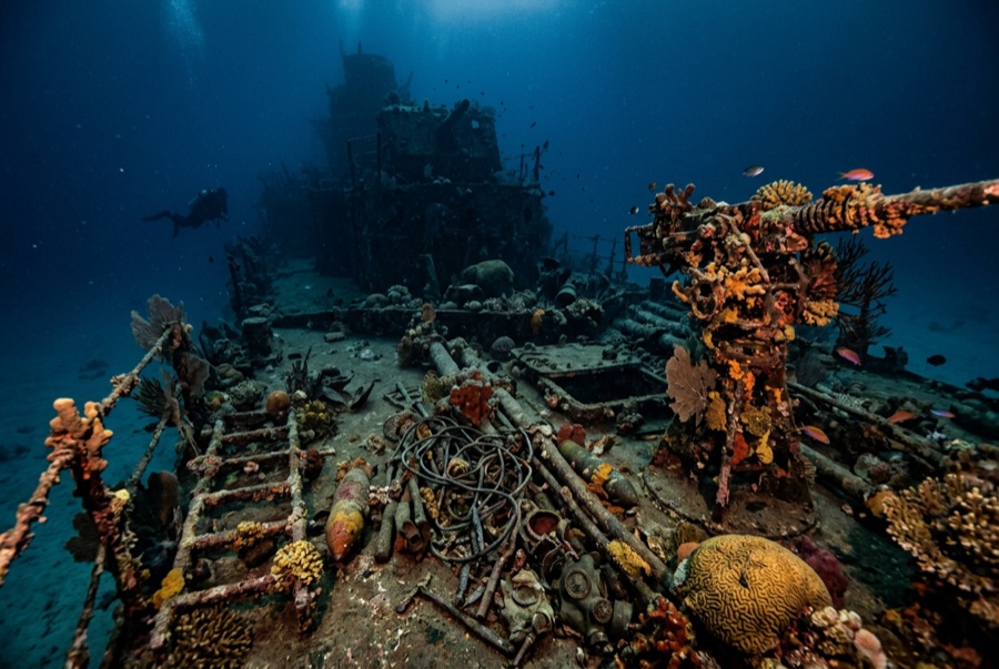
The Iro was a fleet oiler of the 1920s generation, a 143-meter tanker built in 1922 to keep warships fueled at sea. By early 1944 she was running supplies through an emptying empire. On 22 March the submarine USS Tunny put a torpedo into her bow; she limped into Palau's anchorage for repairs, and was still there on 30 March when Operation Desecrate One, the Palau counterpart to Truk's Hailstone raid, swept in. Carrier aircraft left her burning, and she went down upright in the sheltered water southwest of Koror. She has aged into one of Palau's signature wreck dives. Her kingposts rise like coral chimneys toward the light, a bow gun still sits on its bandstand platform above the torpedo-crumpled plating, and the aft superstructure opens into shadowy, manageable spaces. Between world-famous reef days, she is where Palau divers go to remember that the war passed this way too.

Bagaimana kapal ini tenggelam: Torpedoed by USS Tunny in March 1944, then sunk at anchor by carrier aircraft during Operation Desecrate One, 30–31 March 1944.

Menyelaminya hari ini

Kondisi: Upright and whole, with lagoon sediment softening her lines; the bow damage from the torpedo is still legible.

Penetrasi: Limited. The aft deckhouse and engine-room skylights admit trained wreck divers; deep machinery spaces are dark, oily, and best left alone. Memasuki lingkungan overhead apa pun memerlukan pelatihan khusus: minimal sertifikasi wreck diving, dan pelatihan wreck teknis untuk penetrasi penuh.

Sertifikasi yang disarankan: Advanced Open Water with deep experience

Arus: Mild · Visibilitas: 10–20 m

Kehidupan laut: Soft corals and oysters crust the kingposts, batfish and barracuda circle the masts, and lionfish hold the gun platform.

Bahaya: Lagoon visibility can drop with wind and tide; silt inside; residual oil films in overhead spaces.

Perlindungan & hukum

Palau's wrecks are protected historic sites; permits through licensed operators apply.

Palau law forbids removing anything from its historic wrecks.

Tonton

Dari saluran resmi

Semua video →

Video adalah tautan tertanam ke saluran milik kreatornya sendiri. Kami tidak meng-host apa pun dan selalu mencantumkan kredit.

Sumber: CombinedFleet.com ↗PacificWrecks.com ↗ · Fakta diverifikasi terhadap sumber-sumber di atas; kolom yang belum didukung data diberi label belum diverifikasi.

Australia, Selandia Baru & Asia Timur

Cairns & the Ribbon ReefsNingaloo ReefCoral Sea & Osprey ReefOkinawa & the Kerama IslandsPoor Knights IslandsTownsville & the YongalaGreen IslandIzu Peninsula

Karibia & Atlantik Barat

BonaireCozumelRiviera Maya & the CenotesBelize Barrier ReefGrand CaymanIsla Mujeres & CancúnRoatánTiger Beach & Grand Bahama

Eropa, Atlantik & Mediterania

Malta & GozoSilfra & IcelandThe AzoresCanary IslandsLarnaca & the ZenobiaScapa FlowArctic NorwayMadeira

Samudra Hindia & Afrika Timur

North & South Malé AtollsAri AtollBaa Atoll & Hanifaru BayAliwal Shoal & UmkomaasMafia IslandMauritiusSeychellesSodwana Bay

Kepulauan Pasifik & Mikronesia

PalauChuuk (Truk) LagoonFakaravaKona, HawaiʻiRangiroaTaveuni & Rainbow ReefBeqa Lagoon & Pacific HarbourEspiritu Santo

Laut Merah & Timur Tengah

Sharm El Sheikh & Ras MohammedBrothers, Daedalus & St John'sDahabHurghada & El GounaMarsa Alam & the Deep SouthAqabaDaymaniyat IslandsMusandam Peninsula

Asia Tenggara & Segitiga Terumbu Karang

Bali & Nusa PenidaKomodoRaja AmpatSipadan & MabulAnilaoCoronKoh TaoLembeh Strait

Amerika & Pasifik Timur

Galápagos IslandsCocos IslandFlorida KeysSea of Cortez & Cabo PulmoSocorro & the RevillagigedosBritish ColumbiaCalifornia Channel IslandsCosta Rica Pacific Coast