Puntos de buceo, temporadas y vida marina — investigados, cartografiados, planificados.
Menú
Destinos Puntos de buceo Vida marina Pecios Noticias
Planifica un viaje Planificador de viajes Cuándo bucear Calculadora de costes Comparativas Calendario de fauna marina Temperatura del agua Liveaboards Operadores y resorts Parques marinos Cámaras hiperbáricas Mapa mundial
Regiones Australia, Nueva Zelanda y Asia OrientalCaribe y Atlántico occidentalEuropa, Atlántico y MediterráneoOcéano Índico y África OrientalIslas del Pacífico y MicronesiaMar Rojo y Oriente MedioSudeste Asiático y el Triángulo del CoralLas Américas y el Pacífico Oriental Países
Aprender y herramientas Todas las guías Certificaciones Guías de equipo Vídeos Consulta los datos Agentes de IA API
Acerca de Quiénes somos Metodología Aviso legal Contacto
Tu vista
★ Guardado

Tus destinos, sitios y especies favoritos — guardados en este navegador.

API GATEWAY

Acceso JSON gratuito de solo lectura a los datos en caché del atlas.

Modo oscuro

🧭 Vista guiada
¿Nuevo en el buceo? ¿Profundidades, corrientes, niveles de certificación? Explicamos cada término mientras navegas, en un lenguaje claro. Los mismos datos, con la ayuda integrada.

⚡ Vista experta
Ya conoces la diferencia entre una pared y un drift dive. Solo los datos — claros, rápidos y concisos. Esta es la vista predeterminada.

Idioma de la interfaz
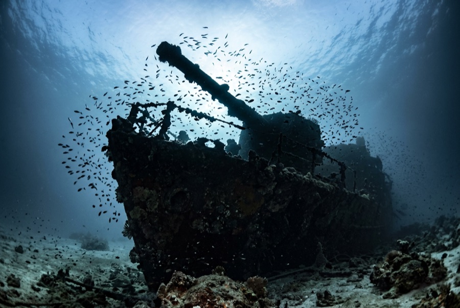
Kimon M — illustrative image

Kimon M

German-built general cargo freighter Hundido 1978 10–32 m Hurghada & El Gouna
Ilustración generada por IA
Aquí se perdieron vidasNone — the crew was rescued. Los operadores locales piden que el pecio se bucee con el respeto correspondiente.
Documentado
Profundidad hasta cubierta
10 m / 33 ft
Profundidad máxima
32 m / 105 ft
Construido / hundido
1952 / 1978
Longitud
106 m
Orientación
On Her Starboard Side, Stern Deepest
Nivel
Intermediate
Mejores meses
Mar, Apr, May, Jun, Sep, Oct, Nov

La historia

Every ship on Abu Nuhas earned a nickname from its cargo, and the Kimon M drew the humblest: the Lentil Wreck. A German-built freighter of 1952 vintage sailing under later Greek ownership, she loaded some four and a half thousand tons of lentils at Iskenderun in Turkey, bound for Bombay. On 12 December 1978, running the Strait of Gubal at full sea speed, she piled onto the reef's northeast corner — the same low coral shelf that had already claimed the Carnatic a century earlier and would take the Giannis D and Chrisoula K within a few years. The crew was lifted off safely. The ship sat high on the reef until salvors removed her engines; storms then pushed the hull over the edge, where it settled on its starboard side down the slope. The cargo fermented away long ago, leaving open holds, a photogenic stern, and the quietest corner of the Red Sea's busiest wreck reef.

Cómo se hundió: Ran onto the northeast corner of Sha'ab Abu Nuhas at full speed, 12 December 1978.

Buceando aquí hoy

Condición: The stern half is coherent and rewarding; the bow region is flattened wreckage fused into the reef where she first struck.

Penetración: Limited. The aft holds and shaft area allow short, bright pass-throughs for trained divers; the crushed forward section is best admired from outside. Acceder a cualquier entorno de penetración exige formación específica — como mínimo una certificación en pecios, y formación técnica en pecios para penetración completa.

Certificación recomendada: Advanced Open Water

Corriente: Mild · Visibilidad: 10–25 m

Vida marina: Glassfish and sweepers in the stern spaces, morays in the toppled framework, anthias over the hull, and groupers holding the shaded holds.

Riesgos: Surge near the reef crest, sharp collapsed plating forward, and boat traffic above a popular anchorage.

Protección y legislación

Egyptian rules protect all the Abu Nuhas wrecks — remove nothing.

Ver

Desde los canales oficiales

Todos los vídeos →

Los vídeos son enlaces incrustados a los canales propios de sus creadores — no alojamos nada y acreditamos todo.

Fuentes: Divernet ↗ · Datos verificados frente a las fuentes anteriores; los campos sin respaldo se marcan como aún no verificados.

Australia, Nueva Zelanda y Asia Oriental

Cairns & the Ribbon ReefsNingaloo ReefCoral Sea & Osprey ReefOkinawa & the Kerama IslandsPoor Knights IslandsTownsville & the YongalaGreen IslandIzu Peninsula

Caribe y Atlántico occidental

BonaireCozumelRiviera Maya & the CenotesBelize Barrier ReefGrand CaymanIsla Mujeres & CancúnRoatánTiger Beach & Grand Bahama

Europa, Atlántico y Mediterráneo

Malta & GozoSilfra & IcelandThe AzoresCanary IslandsLarnaca & the ZenobiaScapa FlowArctic NorwayMadeira

Océano Índico y África Oriental

North & South Malé AtollsAri AtollBaa Atoll & Hanifaru BayAliwal Shoal & UmkomaasMafia IslandMauritiusSeychellesSodwana Bay

Islas del Pacífico y Micronesia

PalauChuuk (Truk) LagoonFakaravaKona, HawaiʻiRangiroaTaveuni & Rainbow ReefBeqa Lagoon & Pacific HarbourEspiritu Santo

Mar Rojo y Oriente Medio

Sharm El Sheikh & Ras MohammedBrothers, Daedalus & St John'sDahabHurghada & El GounaMarsa Alam & the Deep SouthAqabaDaymaniyat IslandsMusandam Peninsula

Sudeste Asiático y el Triángulo del Coral

Bali & Nusa PenidaKomodoRaja AmpatSipadan & MabulAnilaoCoronKoh TaoLembeh Strait

Las Américas y el Pacífico Oriental

Galápagos IslandsCocos IslandFlorida KeysSea of Cortez & Cabo PulmoSocorro & the RevillagigedosBritish ColumbiaCalifornia Channel IslandsCosta Rica Pacific Coast