Situs selam, musim, dan kehidupan laut — diteliti, dipetakan, direncanakan.
Menu
Destinasi Lokasi Selam Kehidupan Laut Bangkai kapal Berita
Rencanakan perjalanan Perencana trip Kapan waktu terbaik menyelam Kalkulator biaya Perbandingan Kalender kehidupan laut Suhu air Liveaboard Operator & resor Taman laut Ruang hiperbarik Peta dunia
Wilayah Australia, Selandia Baru & Asia TimurKaribia & Atlantik BaratEropa, Atlantik & MediteraniaSamudra Hindia & Afrika TimurKepulauan Pasifik & MikronesiaLaut Merah & Timur TengahAsia Tenggara & Segitiga Terumbu KarangAmerika & Pasifik Timur Negara
Pelajari & Alat Semua panduan Sertifikasi Panduan perlengkapan Video Tanya Data Agen AI API
Tentang Tentang kami Metodologi Penafian Kontak
Tampilan kamu
★ Tersimpan

Destinasi, lokasi selam, dan spesies favorit yang kamu bintangi — tersimpan di browser ini.

API GATEWAY

Akses JSON gratis hanya-baca ke data cache atlas.

Mode gelap

🧭 Tampilan Terpandu
Baru mengenal menyelam — kedalaman, arus, level sertifikasi? Kami menjelaskan setiap istilah saat kamu menjelajah, dalam bahasa yang mudah dipahami. Data yang sama, lengkap dengan panduan bawaan.

⚡ Tampilan Ahli
Kamu sudah tahu perbedaan antara wall dive dan drift dive. Cukup datanya — bersih, cepat, dan ringkas. Ini adalah tampilan default.

Bahasa antarmuka
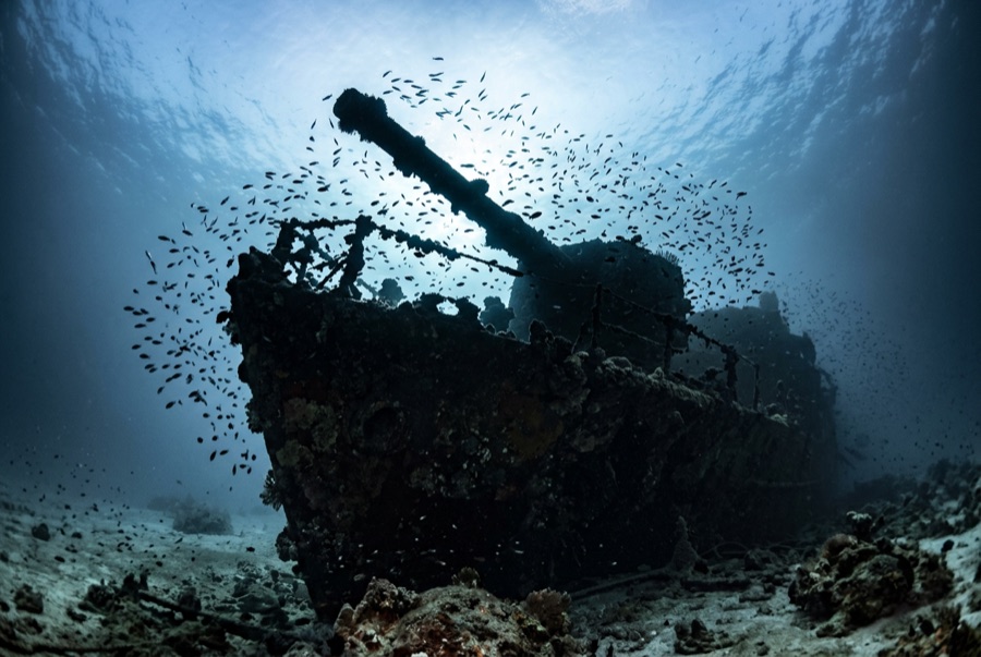
Numidia — illustrative image

Numidia

British cargo steamer Ditenggelamkan 1901 8–80 m Brothers, Daedalus & St John's
Ilustrasi hasil AI
Ada nyawa yang melayang di siniNo lives were lost. Operator lokal meminta agar bangkai kapal ini diselami dengan rasa hormat yang sepadan.
Terdokumentasi
Kedalaman ke dek
8 m / 26 ft
Kedalaman maksimum
80 m / 262 ft
Dibangun / ditenggelamkan
1901 / 1901
Panjang
137 m
Tonase
6,399 GRT
Orientasi
Lying Down The Reef Slope, Bow Shallow, Stern Far Below
Level
Advanced
Bulan-bulan terbaik
Mar, Apr, May, Jun, Sep, Oct, Nov

Kisahnya

Numidia was almost new when she died. Completed on the Clyde in 1901 for the Anchor Line, she was weeks into only her second voyage, London for Calcutta, when in the early hours of 20 July 1901 she steamed straight onto the north point of Big Brother — a mile-long island with a lighthouse that was lit and working. The crew got off without loss, and salvors spent weeks stripping what they could reach while the hull ground on the reef. Then she slipped, and gravity arranged one of the most dramatic wrecks in the Red Sea: a ship draped bow-up down a near-vertical wall, upper works beginning within ten meters of the surface and the stern fading past the edge of sport-diving depth. Pairs of railway wheels from her cargo still lie stacked near the island. A century of soft coral has upholstered every surviving beam.

Bagaimana kapal ini tenggelam: Ran onto the northern point of Big Brother Island, 20 July 1901.

Menyelaminya hari ini

Kondisi: The shallow section is broken and coral-fused; the deeper hull holds its shape, becoming more intact the farther down the wall it goes.

Penetrasi: Limited. Short pass-throughs in the forward section suit trained divers; anything deep inside the down-slope hull becomes a technical dive quickly. Memasuki area overhead apa pun memerlukan pelatihan khusus — minimal sertifikasi wreck, dan pelatihan wreck teknis untuk penetrasi penuh.

Sertifikasi yang disarankan: Advanced Open Water with deep experience; technical training below 40 m

Arus: Strong · Visibilitas: 20–40 m

Kehidupan laut: Soft corals in full riot, anthias in their thousands, and grey reef sharks — with oceanic whitetips and hammerheads possible off the wall in season.

Bahaya: Strong, shifting currents around the island, exposed offshore position, and a wreck that invites divers deeper than they planned — watch depth and gas.

Perlindungan & hukum

Lies within Egypt's offshore marine-park islands; liveaboard permits and park fees apply.

Tonton

Dari saluran resmi

Semua video →

Video adalah tautan sematan ke kanal milik kreatornya sendiri — kami tidak meng-host apa pun dan selalu mencantumkan kredit.

Sumber: Divernet ↗ · Fakta diverifikasi terhadap sumber-sumber di atas; kolom yang belum didukung data diberi label belum diverifikasi.

Australia, Selandia Baru & Asia Timur

Cairns & the Ribbon ReefsNingaloo ReefCoral Sea & Osprey ReefOkinawa & the Kerama IslandsPoor Knights IslandsTownsville & the YongalaGreen IslandIzu Peninsula

Karibia & Atlantik Barat

BonaireCozumelRiviera Maya & the CenotesBelize Barrier ReefGrand CaymanIsla Mujeres & CancúnRoatánTiger Beach & Grand Bahama

Eropa, Atlantik & Mediterania

Malta & GozoSilfra & IcelandThe AzoresCanary IslandsLarnaca & the ZenobiaScapa FlowArctic NorwayMadeira

Samudra Hindia & Afrika Timur

North & South Malé AtollsAri AtollBaa Atoll & Hanifaru BayAliwal Shoal & UmkomaasMafia IslandMauritiusSeychellesSodwana Bay

Kepulauan Pasifik & Mikronesia

PalauChuuk (Truk) LagoonFakaravaKona, HawaiʻiRangiroaTaveuni & Rainbow ReefBeqa Lagoon & Pacific HarbourEspiritu Santo

Laut Merah & Timur Tengah

Sharm El Sheikh & Ras MohammedBrothers, Daedalus & St John'sDahabHurghada & El GounaMarsa Alam & the Deep SouthAqabaDaymaniyat IslandsMusandam Peninsula

Asia Tenggara & Segitiga Terumbu Karang

Bali & Nusa PenidaKomodoRaja AmpatSipadan & MabulAnilaoCoronKoh TaoLembeh Strait

Amerika & Pasifik Timur

Galápagos IslandsCocos IslandFlorida KeysSea of Cortez & Cabo PulmoSocorro & the RevillagigedosBritish ColumbiaCalifornia Channel IslandsCosta Rica Pacific Coast