Descubra onde mergulhar, quando ir e o que poderá ver.

Descubra onde mergulhar, quando ir e o que poderá ver.
★
Menu
Destinos Pontos de Mergulho Vida Marinha Naufrágios Notícias
Planejar uma viagem Planejador de viagem Quando mergulhar Calculadora de custos Comparações Calendário de vida marinha Temperatura da água Liveaboards Operadores & resorts Parques marinhos Câmaras hiperbáricas Mapa mundial
Mergulho em cavernas Todo o mergulho em cavernas Destinos e Pontos de Mergulho Sistemas de Cavernas e Mapas Formação e qualificações Centros de Mergulho e Guias Equipamento e Tecnologia Pesquisa de segurança e incidentes Ciência, história e conservação Recursos e atualizações
Regiões Austrália, Nova Zelândia e Ásia OrientalCaribe e Atlântico OcidentalEuropa, Atlântico & MediterrâneoOceano Índico e África OrientalIlhas do Pacífico & MicronésiaMar Vermelho & Médio OrienteSudeste Asiático e Triângulo de CoralAs Américas e o Pacífico Oriental Países
Aprender e Ferramentas Todos os guias Certificações Guias de equipamento Vídeos Consulte os Dados Agentes de IA API
Sobre Sobre nós Metodologia Aviso legal Contato
A sua vista
★ Guardado

Os seus destinos, pontos de mergulho e espécies favoritos, guardados neste browser.

API GATEWAY

Acesso JSON gratuito e só de leitura aos dados em cache do atlas.

Modo escuro

Vista Guiada
Novo no mergulho? Profundidades, correntes, níveis de certificação? Explicamos cada termo enquanto navegas, em linguagem simples. Os mesmos dados, com a ajuda incluída.

Vista de Especialista
Já sabe a diferença entre uma parede e um drift dive. Apenas os dados: limpos, rápidos e compactos. Esta é a vista predefinida.

Idioma da interface
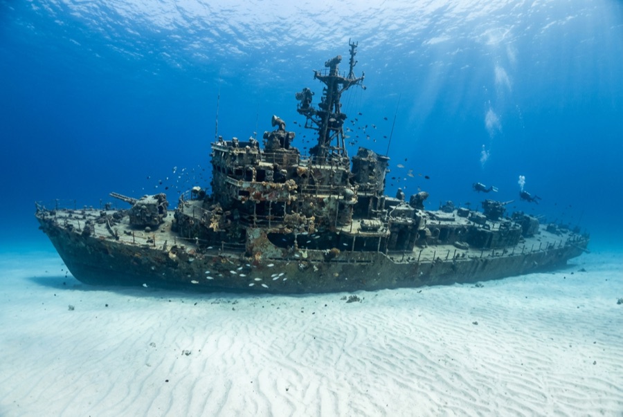
Ray of Hope

Ray of Hope

Coastal freighter Afundado 2003 ~15 m Nassau & New Providence
Ilustração gerada por IA
Não houve vítimas mortais aquiNone (planned scuttling).
Documentado
Profundidade máxima
15 m / 49 ft
Construído / afundado
? / 2003
Comprimento
60 m
Orientação
Upright
Nível
Beginner
Melhores meses
Nov–May

A história

The Ray of Hope is a working ship turned film set turned shark theater. A roughly 60-meter freighter of the kind that shuttles freight through the Bahamas, she was acquired, cleaned and scuttled in 2003 on the sand flats along southwest New Providence's drop-off, joining a cluster of wrecks placed over the years for divers and for Hollywood. This stretch of coast has doubled for open ocean in Bond films and countless productions. She landed upright, bow toward the wall, and would be a pleasant if unremarkable reef dive except for her neighbors: the site sits beside one of the Caribbean's longest-running shark feeds, and Caribbean reef sharks treat the wreck as part of their patrol route. Even on unbaited dives it is normal to descend through a loose spiral of sharks and find more resting in the sand lee of the hull. The holds are open and bright, grouper and horse-eye jacks crowd the superstructure, and the short swim to the wall lets one dive combine wreck, reef edge and big animals.

Como afundou: Deliberately scuttled as an artificial reef off southwest New Providence, 2003.

A mergulhar nela hoje

Condição: Upright and intact, colonization young but spreading; structure sound

Penetração: Limited. Cargo holds and the wheelhouse are open with multiple exits; genuine enclosed penetration is limited and should stay with trained divers. Entrar em qualquer ambiente overhead requer formação específica: uma certificação de naufrágio no mínimo, formação técnica de naufrágio para penetração total.

Certificação recomendada: Open Water

Corrente: Mild · Visibilidade: 15–30 m

Vida marinha: Caribbean reef sharks are the constant (circling, resting on sand, shadowing divers), joined by grouper, horse-eye jacks, southern stingrays and a resident green moray.

Perigos: Sharks conditioned by nearby feeds approach closely; keep hands in and follow briefings

Assista

Dos canais oficiais

Todos os vídeos →

Os vídeos são ligações incorporadas para os canais dos próprios criadores. Não alojamos nada e creditamos tudo.

Fontes: Stuart Cove's Dive Bahamas ↗Bahamas Ministry of Tourism ↗ · Factos verificados em relação às fontes acima; os campos sem suporte estão assinalados como não verificado ainda.

Austrália, Nova Zelândia e Ásia Oriental

Cairns & the Ribbon ReefsNingaloo ReefCoral Sea & Osprey ReefOkinawa & the Kerama IslandsPoor Knights IslandsTownsville & the YongalaGreen IslandIzu Peninsula

Caribe e Atlântico Ocidental

BonaireCozumelRiviera Maya & the CenotesBelize Barrier ReefGrand CaymanIsla Mujeres & CancúnRoatánTiger Beach & Grand Bahama

Europa, Atlântico & Mediterrâneo

Malta & GozoSilfra & IcelandThe AzoresCanary IslandsLarnaca & the ZenobiaScapa FlowArctic NorwayMadeira

Oceano Índico e África Oriental

North & South Malé AtollsAri AtollBaa Atoll & Hanifaru BayAliwal Shoal & UmkomaasMafia IslandMauritiusSeychellesSodwana Bay

Ilhas do Pacífico & Micronésia

PalauChuuk (Truk) LagoonFakaravaKona, HawaiʻiRangiroaTaveuni & Rainbow ReefBeqa Lagoon & Pacific HarbourEspiritu Santo

Mar Vermelho & Médio Oriente

Sharm El Sheikh & Ras MohammedBrothers, Daedalus & St John'sDahabHurghada & El GounaMarsa Alam & the Deep SouthAqabaDaymaniyat IslandsMusandam Peninsula

Sudeste Asiático e Triângulo de Coral

Bali & Nusa PenidaKomodoRaja AmpatSipadan & MabulAnilaoCoronKoh TaoLembeh Strait

As Américas e o Pacífico Oriental

Galápagos IslandsCocos IslandFlorida KeysSea of Cortez & Cabo PulmoSocorro & the RevillagigedosBritish ColumbiaCalifornia Channel IslandsCosta Rica Pacific Coast