Puntos de buceo, temporadas y vida marina — investigados, cartografiados, planificados.
Menú
Destinos Puntos de buceo Vida marina Pecios Noticias
Planifica un viaje Planificador de viajes Cuándo bucear Calculadora de costes Comparativas Calendario de fauna marina Temperatura del agua Liveaboards Operadores y resorts Parques marinos Cámaras hiperbáricas Mapa mundial
Regiones Australia, Nueva Zelanda y Asia OrientalCaribe y Atlántico occidentalEuropa, Atlántico y MediterráneoOcéano Índico y África OrientalIslas del Pacífico y MicronesiaMar Rojo y Oriente MedioSudeste Asiático y el Triángulo del CoralLas Américas y el Pacífico Oriental Países
Aprender y herramientas Todas las guías Certificaciones Guías de equipo Vídeos Consulta los datos Agentes de IA API
Acerca de Quiénes somos Metodología Aviso legal Contacto
Tu vista
★ Guardado

Tus destinos, sitios y especies favoritos — guardados en este navegador.

API GATEWAY

Acceso JSON gratuito de solo lectura a los datos en caché del atlas.

Modo oscuro

🧭 Vista guiada
¿Nuevo en el buceo? ¿Profundidades, corrientes, niveles de certificación? Explicamos cada término mientras navegas, en un lenguaje claro. Los mismos datos, con la ayuda integrada.

⚡ Vista experta
Ya conoces la diferencia entre una pared y un drift dive. Solo los datos — claros, rápidos y concisos. Esta es la vista predeterminada.

Idioma de la interfaz
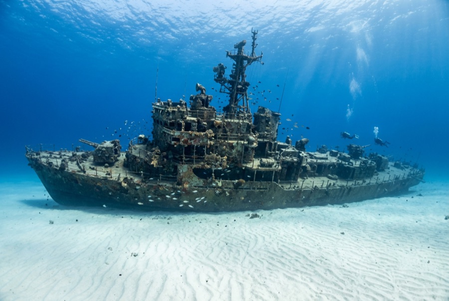
Ray of Hope — illustrative image

Ray of Hope

Coastal freighter Hundido 2003 ~15 m Nassau & New Providence
Ilustración generada por IA
Aquí se perdieron vidasNone (planned scuttling). Los operadores locales piden que el pecio se bucee con el respeto correspondiente.
Documentado
Profundidad máxima
15 m / 49 ft
Construido / hundido
? / 2003
Longitud
60 m
Orientación
Upright
Nivel
Beginner
Mejores meses
Nov–May

La historia

The Ray of Hope is a working ship turned film set turned shark theater. A roughly 60-meter freighter of the kind that shuttles freight through the Bahamas, she was acquired, cleaned and scuttled in 2003 on the sand flats along southwest New Providence's drop-off, joining a cluster of wrecks placed over the years for divers and for Hollywood — this stretch of coast has doubled for open ocean in Bond films and countless productions. She landed upright, bow toward the wall, and would be a pleasant if unremarkable reef dive except for her neighbors: the site sits beside one of the Caribbean's longest-running shark feeds, and Caribbean reef sharks treat the wreck as part of their patrol route. Even on unbaited dives it is normal to descend through a loose spiral of sharks and find more resting in the sand lee of the hull. The holds are open and bright, grouper and horse-eye jacks crowd the superstructure, and the short swim to the wall lets one dive combine wreck, reef edge and big animals.

Cómo se hundió: Deliberately scuttled as an artificial reef off southwest New Providence, 2003.

Buceando aquí hoy

Condición: Upright and intact, colonization young but spreading; structure sound

Penetración: Limited. Cargo holds and the wheelhouse are open with multiple exits; genuine enclosed penetration is limited and should stay with trained divers. Acceder a cualquier entorno de penetración exige formación específica — como mínimo una certificación en pecios, y formación técnica en pecios para penetración completa.

Certificación recomendada: Open Water

Corriente: Mild · Visibilidad: 15–30 m

Vida marina: Caribbean reef sharks are the constant — circling, resting on sand, shadowing divers — joined by grouper, horse-eye jacks, southern stingrays and a resident green moray.

Riesgos: Sharks conditioned by nearby feeds approach closely — keep hands in and follow briefings

Ver

Desde los canales oficiales

Todos los vídeos →

Los vídeos son enlaces incrustados a los canales propios de sus creadores — no alojamos nada y acreditamos todo.

Fuentes: Stuart Cove's Dive Bahamas ↗Bahamas Ministry of Tourism ↗ · Datos verificados frente a las fuentes anteriores; los campos sin respaldo se marcan como aún no verificados.

Australia, Nueva Zelanda y Asia Oriental

Cairns & the Ribbon ReefsNingaloo ReefCoral Sea & Osprey ReefOkinawa & the Kerama IslandsPoor Knights IslandsTownsville & the YongalaGreen IslandIzu Peninsula

Caribe y Atlántico occidental

BonaireCozumelRiviera Maya & the CenotesBelize Barrier ReefGrand CaymanIsla Mujeres & CancúnRoatánTiger Beach & Grand Bahama

Europa, Atlántico y Mediterráneo

Malta & GozoSilfra & IcelandThe AzoresCanary IslandsLarnaca & the ZenobiaScapa FlowArctic NorwayMadeira

Océano Índico y África Oriental

North & South Malé AtollsAri AtollBaa Atoll & Hanifaru BayAliwal Shoal & UmkomaasMafia IslandMauritiusSeychellesSodwana Bay

Islas del Pacífico y Micronesia

PalauChuuk (Truk) LagoonFakaravaKona, HawaiʻiRangiroaTaveuni & Rainbow ReefBeqa Lagoon & Pacific HarbourEspiritu Santo

Mar Rojo y Oriente Medio

Sharm El Sheikh & Ras MohammedBrothers, Daedalus & St John'sDahabHurghada & El GounaMarsa Alam & the Deep SouthAqabaDaymaniyat IslandsMusandam Peninsula

Sudeste Asiático y el Triángulo del Coral

Bali & Nusa PenidaKomodoRaja AmpatSipadan & MabulAnilaoCoronKoh TaoLembeh Strait

Las Américas y el Pacífico Oriental

Galápagos IslandsCocos IslandFlorida KeysSea of Cortez & Cabo PulmoSocorro & the RevillagigedosBritish ColumbiaCalifornia Channel IslandsCosta Rica Pacific Coast