Temukan tempat menyelam, waktu terbaik untuk pergi, dan apa yang bisa Anda lihat.

Temukan tempat menyelam, waktu terbaik untuk pergi, dan apa yang bisa Anda lihat.
★
Menu
Destinasi Lokasi Selam Kehidupan Laut Bangkai kapal Berita
Rencanakan perjalanan Perencana trip Kapan waktu terbaik menyelam Kalkulator biaya Perbandingan Kalender kehidupan laut Suhu air Liveaboard Operator & resor Taman laut Ruang hiperbarik Peta dunia
Selam gua Semua cave diving Destinasi & Lokasi Selam Sistem Cave & Peta Pelatihan & Kualifikasi Pusat Selam & Pemandu Peralatan & Teknologi Riset Keselamatan & Insiden Sains, Sejarah & Konservasi Sumber Daya & Pembaruan
Wilayah Australia, Selandia Baru & Asia TimurKaribia & Atlantik BaratEropa, Atlantik & MediteraniaSamudra Hindia & Afrika TimurKepulauan Pasifik & MikronesiaLaut Merah & Timur TengahAsia Tenggara & Segitiga Terumbu KarangAmerika & Pasifik Timur Negara
Pelajari & Alat Semua panduan Sertifikasi Panduan perlengkapan Video Tanya Data Agen AI API
Tentang Tentang kami Metodologi Penafian Kontak
Tampilan kamu
★ Tersimpan

Destinasi, situs, dan spesies yang kamu tandai bintang, tersimpan di browser ini.

API GATEWAY

Akses JSON gratis hanya-baca ke data cache atlas.

Mode gelap

Tampilan Terpandu
Baru menyelam? Kedalaman, arus, level sertifikasi? Kami menjelaskan setiap istilah saat kamu menjelajah, dalam bahasa yang mudah dipahami. Data yang sama, dengan bantuan yang sudah terintegrasi.

Tampilan Ahli
Kamu sudah tahu perbedaan antara wall dan drift dive. Cukup datanya: bersih, cepat, dan ringkas. Ini adalah tampilan default.

Bahasa antarmuka
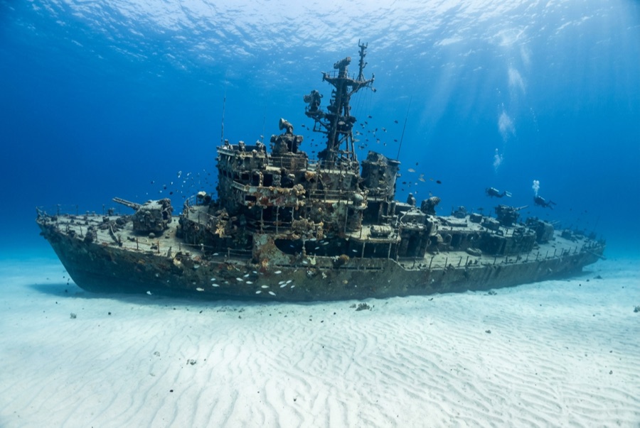
Ray of Hope

Ray of Hope

Coastal freighter Ditenggelamkan 2003 ~15 m Nassau & New Providence
Ilustrasi hasil AI
Tidak ada korban jiwa di siniNone (planned scuttling).
Terdokumentasi
Kedalaman maksimum
15 m / 49 ft
Dibangun / ditenggelamkan
? / 2003
Panjang
60 m
Orientasi
Upright
Level
Beginner
Bulan-bulan terbaik
Nov–May

Kisahnya

The Ray of Hope is a working ship turned film set turned shark theater. A roughly 60-meter freighter of the kind that shuttles freight through the Bahamas, she was acquired, cleaned and scuttled in 2003 on the sand flats along southwest New Providence's drop-off, joining a cluster of wrecks placed over the years for divers and for Hollywood. This stretch of coast has doubled for open ocean in Bond films and countless productions. She landed upright, bow toward the wall, and would be a pleasant if unremarkable reef dive except for her neighbors: the site sits beside one of the Caribbean's longest-running shark feeds, and Caribbean reef sharks treat the wreck as part of their patrol route. Even on unbaited dives it is normal to descend through a loose spiral of sharks and find more resting in the sand lee of the hull. The holds are open and bright, grouper and horse-eye jacks crowd the superstructure, and the short swim to the wall lets one dive combine wreck, reef edge and big animals.

Bagaimana kapal ini tenggelam: Deliberately scuttled as an artificial reef off southwest New Providence, 2003.

Menyelaminya hari ini

Kondisi: Upright and intact, colonization young but spreading; structure sound

Penetrasi: Limited. Cargo holds and the wheelhouse are open with multiple exits; genuine enclosed penetration is limited and should stay with trained divers. Memasuki lingkungan overhead apa pun memerlukan pelatihan khusus: minimal sertifikasi wreck diving, dan pelatihan wreck teknis untuk penetrasi penuh.

Sertifikasi yang disarankan: Open Water

Arus: Mild · Visibilitas: 15–30 m

Kehidupan laut: Caribbean reef sharks are the constant (circling, resting on sand, shadowing divers), joined by grouper, horse-eye jacks, southern stingrays and a resident green moray.

Bahaya: Sharks conditioned by nearby feeds approach closely; keep hands in and follow briefings

Tonton

Dari saluran resmi

Semua video →

Video adalah tautan tertanam ke saluran milik kreatornya sendiri. Kami tidak meng-host apa pun dan selalu mencantumkan kredit.

Sumber: Stuart Cove's Dive Bahamas ↗Bahamas Ministry of Tourism ↗ · Fakta diverifikasi terhadap sumber-sumber di atas; kolom yang belum didukung data diberi label belum diverifikasi.

Australia, Selandia Baru & Asia Timur

Cairns & the Ribbon ReefsNingaloo ReefCoral Sea & Osprey ReefOkinawa & the Kerama IslandsPoor Knights IslandsTownsville & the YongalaGreen IslandIzu Peninsula

Karibia & Atlantik Barat

BonaireCozumelRiviera Maya & the CenotesBelize Barrier ReefGrand CaymanIsla Mujeres & CancúnRoatánTiger Beach & Grand Bahama

Eropa, Atlantik & Mediterania

Malta & GozoSilfra & IcelandThe AzoresCanary IslandsLarnaca & the ZenobiaScapa FlowArctic NorwayMadeira

Samudra Hindia & Afrika Timur

North & South Malé AtollsAri AtollBaa Atoll & Hanifaru BayAliwal Shoal & UmkomaasMafia IslandMauritiusSeychellesSodwana Bay

Kepulauan Pasifik & Mikronesia

PalauChuuk (Truk) LagoonFakaravaKona, HawaiʻiRangiroaTaveuni & Rainbow ReefBeqa Lagoon & Pacific HarbourEspiritu Santo

Laut Merah & Timur Tengah

Sharm El Sheikh & Ras MohammedBrothers, Daedalus & St John'sDahabHurghada & El GounaMarsa Alam & the Deep SouthAqabaDaymaniyat IslandsMusandam Peninsula

Asia Tenggara & Segitiga Terumbu Karang

Bali & Nusa PenidaKomodoRaja AmpatSipadan & MabulAnilaoCoronKoh TaoLembeh Strait

Amerika & Pasifik Timur

Galápagos IslandsCocos IslandFlorida KeysSea of Cortez & Cabo PulmoSocorro & the RevillagigedosBritish ColumbiaCalifornia Channel IslandsCosta Rica Pacific Coast