Puntos de buceo, temporadas y vida marina — investigados, cartografiados, planificados.
Menú
Destinos Puntos de buceo Vida marina Pecios Noticias
Planifica un viaje Planificador de viajes Cuándo bucear Calculadora de costes Comparativas Calendario de fauna marina Temperatura del agua Liveaboards Operadores y resorts Parques marinos Cámaras hiperbáricas Mapa mundial
Regiones Australia, Nueva Zelanda y Asia OrientalCaribe y Atlántico occidentalEuropa, Atlántico y MediterráneoOcéano Índico y África OrientalIslas del Pacífico y MicronesiaMar Rojo y Oriente MedioSudeste Asiático y el Triángulo del CoralLas Américas y el Pacífico Oriental Países
Aprender y herramientas Todas las guías Certificaciones Guías de equipo Vídeos Consulta los datos Agentes de IA API
Acerca de Quiénes somos Metodología Aviso legal Contacto
Tu vista
★ Guardado

Tus destinos, sitios y especies favoritos — guardados en este navegador.

API GATEWAY

Acceso JSON gratuito de solo lectura a los datos en caché del atlas.

Modo oscuro

🧭 Vista guiada
¿Nuevo en el buceo? ¿Profundidades, corrientes, niveles de certificación? Explicamos cada término mientras navegas, en un lenguaje claro. Los mismos datos, con la ayuda integrada.

⚡ Vista experta
Ya conoces la diferencia entre una pared y un drift dive. Solo los datos — claros, rápidos y concisos. Esta es la vista predeterminada.

Idioma de la interfaz
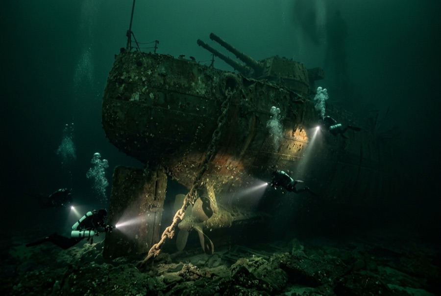
SMS Brummer — illustrative image

SMS Brummer

Brummer-class minelaying light cruiser, German Imperial Navy Hundido 1919 20–36 m Scapa Flow
Ilustración generada por IA
Aquí se perdieron vidasNone aboard her in the scuttling. Los operadores locales piden que el pecio se bucee con el respeto correspondiente.
Bien documentado
Profundidad hasta cubierta
20 m / 66 ft
Profundidad máxima
36 m / 118 ft
Construido / hundido
1915 / 1919
Longitud
140 m
Orientación
Starboard Side
Nivel
Advanced
Mejores meses
Apr–Oct

La historia

Alone among Scapa's seven German survivors, the Brummer was famous in her own right before the scuttling. Built as a fast minelaying cruiser — long, low and deceptively British-looking in silhouette — she and her sister Bremse fell on a Scandinavian convoy in October 1917 and destroyed its two escorting destroyers and much of the merchant column, one of the war's most complete raiding successes and a sharp shock to the Royal Navy. Interned in 1918, she went to the bottom with the fleet on 21 June 1919 and, lying beyond economic salvage, stayed there. Divers find her on her starboard side in about 36 meters in the Bring Deeps, slimmer than the other cruisers and somewhere between them in condition: her forward gun, bridge area and rangefinder remain identifiable, the minelaying deck that made her name can still be traced aft, and amidships the hull is folding down year by year. She rewards an unhurried tour along the port side with a torch — anemone-covered fittings resolve slowly out of the green — and remains the wreck with the best war story in the Flow.

Cómo se hundió: Scuttled with the interned German High Seas Fleet on Admiral von Reuter's order, 21 June 1919.

Buceando aquí hoy

Condición: Intermediate among the cruisers — bow and stern coherent, midships collapsing

Penetración: Limited. Collapsing amidships sections offer holes rather than passages; enclosed spaces are silty and structurally suspect, for technical teams only. Acceder a cualquier entorno de penetración exige formación específica — como mínimo una certificación en pecios, y formación técnica en pecios para penetración completa.

Certificación recomendada: Advanced Open Water with deep and drysuit experience

Corriente: Mild · Visibilidad: 4–12 m

Vida marina: Dense plumose anemones, wrasse and saithe over the hull, congers in the machinery, squat lobsters and edible crabs in every recess.

Riesgos: Depth, cold dark water, degrading structure and old lines

Protección y legislación

Scheduled monument under UK law — look only; removal of any material is an offense

Ver

Desde los canales oficiales

Todos los vídeos →

Los vídeos son enlaces incrustados a los canales propios de sus creadores — no alojamos nada y acreditamos todo.

Fuentes: Historic Environment Scotland ↗Wikipedia ↗ · Datos verificados frente a las fuentes anteriores; los campos sin respaldo se marcan como aún no verificados.

Australia, Nueva Zelanda y Asia Oriental

Cairns & the Ribbon ReefsNingaloo ReefCoral Sea & Osprey ReefOkinawa & the Kerama IslandsPoor Knights IslandsTownsville & the YongalaGreen IslandIzu Peninsula

Caribe y Atlántico occidental

BonaireCozumelRiviera Maya & the CenotesBelize Barrier ReefGrand CaymanIsla Mujeres & CancúnRoatánTiger Beach & Grand Bahama

Europa, Atlántico y Mediterráneo

Malta & GozoSilfra & IcelandThe AzoresCanary IslandsLarnaca & the ZenobiaScapa FlowArctic NorwayMadeira

Océano Índico y África Oriental

North & South Malé AtollsAri AtollBaa Atoll & Hanifaru BayAliwal Shoal & UmkomaasMafia IslandMauritiusSeychellesSodwana Bay

Islas del Pacífico y Micronesia

PalauChuuk (Truk) LagoonFakaravaKona, HawaiʻiRangiroaTaveuni & Rainbow ReefBeqa Lagoon & Pacific HarbourEspiritu Santo

Mar Rojo y Oriente Medio

Sharm El Sheikh & Ras MohammedBrothers, Daedalus & St John'sDahabHurghada & El GounaMarsa Alam & the Deep SouthAqabaDaymaniyat IslandsMusandam Peninsula

Sudeste Asiático y el Triángulo del Coral

Bali & Nusa PenidaKomodoRaja AmpatSipadan & MabulAnilaoCoronKoh TaoLembeh Strait

Las Américas y el Pacífico Oriental

Galápagos IslandsCocos IslandFlorida KeysSea of Cortez & Cabo PulmoSocorro & the RevillagigedosBritish ColumbiaCalifornia Channel IslandsCosta Rica Pacific Coast