Pontos de mergulho, épocas e vida marinha — pesquisados, mapeados, planeados.
Menu
Destinos Pontos de Mergulho Vida Marinha Naufrágios Notícias
Planejar uma viagem Planejador de viagem Quando mergulhar Calculadora de custos Comparações Calendário de vida marinha Temperatura da água Liveaboards Operadores & resorts Parques marinhos Câmaras hiperbáricas Mapa mundial
Regiões Austrália, Nova Zelândia e Ásia OrientalCaribe e Atlântico OcidentalEuropa, Atlântico & MediterrâneoOceano Índico e África OrientalIlhas do Pacífico & MicronésiaMar Vermelho & Médio OrienteSudeste Asiático e Triângulo de CoralAs Américas e o Pacífico Oriental Países
Aprender e Ferramentas Todos os guias Certificações Guias de equipamento Vídeos Consulte os Dados Agentes de IA API
Sobre Sobre nós Metodologia Aviso legal Contato
A sua vista
★ Guardado

Os seus destinos, sítios de mergulho e espécies favoritos — guardados neste browser.

API GATEWAY

Acesso JSON gratuito e só de leitura aos dados em cache do atlas.

Modo escuro

🧭 Vista Guiada
Novo no mergulho — profundidades, correntes, níveis de certificação? Explicamos cada termo enquanto navega, em linguagem simples. Os mesmos dados, com a ajuda integrada.

⚡ Vista de Especialista
Já sabe a diferença entre uma parede e um drift dive. Apenas os dados — claros, rápidos e compactos. Esta é a vista predefinida.

Idioma da interface
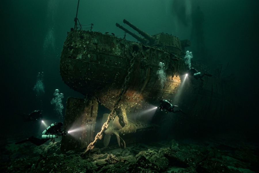
SMS Markgraf — illustrative image

SMS Markgraf

König-class dreadnought battleship, German Imperial Navy Afundado 1919 24–45 m Scapa Flow
Ilustração gerada por IA
Houve vidas perdidas aquiHer captain and another crewman were shot dead by British guards during the scuttling — among nine Germans killed across the fleet that day. Os operadores locais pedem que o naufrágio seja mergulhado com o respeito correspondente.
Bem documentado
Profundidade até o convés
24 m / 79 ft
Profundidade máxima
45 m / 148 ft
Construído / afundado
1913 / 1919
Comprimento
175 m
Orientação
Capsized, Nearly Inverted
Nível
Technical
Melhores meses
Apr–Oct

A história

Markgraf stood in the thick of Jutland in 1916, trading salvos with the British battle line and taking hits that killed members of her crew, then endured the hungry, mutinous final years of the German fleet before sailing into internment at Scapa Flow. On 21 June 1919 she answered von Reuter's scuttling signal, and her sinking carried the day's sharpest tragedy: as British guard boats tried to force crews back aboard, her commanding officer, Walter Schumann, was shot and killed — one of the last men to die in the First World War's naval conflict, months after the armistice. The Markgraf sank into the deepest water of the seven survivors and lies today almost completely upside down in about 45 meters, the most demanding and, many say, the most rewarding of Scapa's battleships. Her hull sides drop like cliff faces, rudders and shafts crown the upturned stern, and along the seabed the casemate guns and armored belt emerge from the gloom. Divers treat her with particular respect, both for her depth and for the men who died with her.

Como afundou: Scuttled with the interned German High Seas Fleet on Admiral von Reuter's order, 21 June 1919.

A mergulhar nela hoje

Condição: Largely intact inverted hull, the least salvage-damaged of the battleships, with slow internal collapse

Penetração: Limited. Interior access is deep technical territory — dark, silted and structurally suspect; most visiting divers never leave the hull exterior. Entrar em qualquer ambiente fechado requer formação específica — no mínimo uma certificação de mergulho em naufrágios, e formação técnica em naufrágios para penetração total.

Certificação recomendada: Deep or technical qualification; the hull top alone suits experienced advanced divers

Corrente: Mild · Visibilidade: 4–12 m

Vida marinha: Anemone-crusted plating, shoals of saithe and pollack along the hull sides, wolf-eel-like butterfish in crevices, congers and lobsters in the wreckage, brittlestar beds on the floor.

Perigos: Depth beyond recreational limits at the seabed, cold and dark, overhead structure, and old netting

Proteção & legislação

Scheduled monument under UK law — look, do not touch, remove nothing

Assista

Dos canais oficiais

Todos os vídeos →

Os vídeos são links incorporados dos próprios canais dos criadores — não hospedamos nada e creditamos tudo.

Fontes: Historic Environment Scotland ↗Wikipedia ↗ · Factos verificados em relação às fontes acima; os campos sem suporte estão assinalados como não verificado ainda.

Austrália, Nova Zelândia e Ásia Oriental

Cairns & the Ribbon ReefsNingaloo ReefCoral Sea & Osprey ReefOkinawa & the Kerama IslandsPoor Knights IslandsTownsville & the YongalaGreen IslandIzu Peninsula

Caribe e Atlântico Ocidental

BonaireCozumelRiviera Maya & the CenotesBelize Barrier ReefGrand CaymanIsla Mujeres & CancúnRoatánTiger Beach & Grand Bahama

Europa, Atlântico & Mediterrâneo

Malta & GozoSilfra & IcelandThe AzoresCanary IslandsLarnaca & the ZenobiaScapa FlowArctic NorwayMadeira

Oceano Índico e África Oriental

North & South Malé AtollsAri AtollBaa Atoll & Hanifaru BayAliwal Shoal & UmkomaasMafia IslandMauritiusSeychellesSodwana Bay

Ilhas do Pacífico & Micronésia

PalauChuuk (Truk) LagoonFakaravaKona, HawaiʻiRangiroaTaveuni & Rainbow ReefBeqa Lagoon & Pacific HarbourEspiritu Santo

Mar Vermelho & Médio Oriente

Sharm El Sheikh & Ras MohammedBrothers, Daedalus & St John'sDahabHurghada & El GounaMarsa Alam & the Deep SouthAqabaDaymaniyat IslandsMusandam Peninsula

Sudeste Asiático e Triângulo de Coral

Bali & Nusa PenidaKomodoRaja AmpatSipadan & MabulAnilaoCoronKoh TaoLembeh Strait

As Américas e o Pacífico Oriental

Galápagos IslandsCocos IslandFlorida KeysSea of Cortez & Cabo PulmoSocorro & the RevillagigedosBritish ColumbiaCalifornia Channel IslandsCosta Rica Pacific Coast