Duiksites, seizoenen en zeeleven — onderzocht, in kaart gebracht, gepland.
Menu
Bestemmingen Duiklocaties Zeeleven Wrakken Nieuws
Plan een reis Reisplanner Wanneer duiken Kostencalculator Vergelijkingen Zeeleven-kalender Watertemperatuur Liveaboards Operators & resorts Mariene parken Hyperbare kamers Wereldkaart
Regio's Australië, Nieuw-Zeeland & Oost-AziëCaribisch gebied & westelijke Atlantische OceaanEuropa, Atlantische Oceaan & Middellandse ZeeIndische Oceaan & Oost-AfrikaPacifische eilanden & MicronesiëRode Zee & Midden-OostenZuidoost-Azië & Coral TriangleDe Amerika's & Oost-Stille Oceaan Landen
Leren & Tools Alle gidsen Brevetten Uitrustingsgidsen Video's Vraag de data AI-agents API
Over Over ons Methodologie Disclaimer Contact
Jouw weergave
★ Opgeslagen

Jouw favoriete bestemmingen, duiklocaties en soorten — opgeslagen in deze browser.

API GATEWAY

Gratis alleen-lezen JSON-toegang tot de gecachede data van de atlas.

Donkere modus

🧭 Begeleide weergave
Nieuw met duiken — dieptes, stromingen, brevetniveaus? We leggen elke term uit terwijl je bladert, in gewone taal. Dezelfde gegevens, met ingebouwde uitleg.

⚡ Expertweergave
Je weet het verschil tussen een wand en een drift dive al. Alleen de data — overzichtelijk, snel en compact. Dit is de standaardweergave.

Interfacetaal
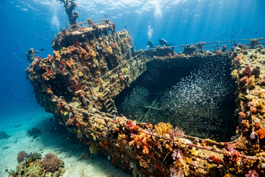
SS Yongala — illustrative image

SS Yongala

Australian coastal passenger and cargo steamer Gezonken 1911 14–28 m Townsville & the Yongala
AI-gegenereerde illustratie
Er zijn levens verloren gegaanAll 122 aboard died. Lokale operators verzoeken het wrak met gepast respect te duiken.
Goed gedocumenteerd
Diepte tot dek
14 m / 46 ft
Maximale diepte
28 m / 92 ft
Gebouwd / gezonken
1903 / 1911
Lengte
110 m
Tonnage
3,664 GRT
Oriëntatie
On Her Starboard Side
Niveau
Advanced
Beste maanden
Aug–Dec

Het verhaal

The Yongala was a crack coastal liner, English-built in 1903 and running the Adelaide–Cairns route for the Adelaide Steamship Company. On 23 March 1911 she steamed north past the Dent Island lighthouse into a cyclone; wireless had been invented but her set had not yet been fitted, so the storm warning could not reach her. She vanished with all 122 people aboard — passengers, crew, and a racehorse named Moonshine whose body coming ashore was among the first evidence of the loss. For decades her fate stayed one of Australia's sea mysteries; a wartime sonar contact was finally confirmed as the Yongala in 1958. She lies on her starboard side on open sand miles from any reef, and that isolation made her an oasis: half a century of larvae drifting past had nowhere else to settle, and she is now routinely called the most life-dense wreck dive on earth. She is also a mass grave, protected by law, dived outside only.

Hoe ze zonk: Lost with all hands in a cyclone off Cape Bowling Green, 23 March 1911.

Duik er vandaag in

Conditie: Protected since 1981 under Australia's Historic Shipwrecks Act 1976, now the Underwater Cultural Heritage Act 2018: the hull is intact but softening, and divers are barred from entering or touching it. Moorings are mandatory; anchoring is banned.

Penetratieduiken: None. Entry is prohibited by law under her protected-zone status — and unnecessary: everything that makes this dive extraordinary lives on the outside.

Aanbevolen certificering: Advanced Open Water

Stroming: Strong · Zicht: 8–20 m

Zeeleven: Giant Queensland groupers, marble rays stacked under the bow, olive sea snakes, turtles, eagle rays, barracuda, snapper in walls, and trevally storms — with bull sharks passing in the cooler months.

Gevaren: Open-ocean current that can run hard the full dive, exposed sea conditions on the crossing, and no sheltering reef; this is a strong-skills dive.

Bescherming & wetgeving

Commonwealth protected zone under the Underwater Cultural Heritage Act 2018; access via permitted operators and fixed moorings only.

She is the grave of 122 people; penetration, artifact disturbance, and anchoring are offenses.

Nothing may be touched or taken — the law and the dead both say so.

Bekijk

Via de officiële kanalen

Alle video's →

Video's zijn ingesloten links naar de kanalen van de makers zelf — wij hosten niets en vermelden altijd de bron.

Bronnen: Queensland Museum Network ↗Wikipedia ↗ · Feiten geverifieerd aan de hand van bovenstaande bronnen; velden zonder onderbouwing zijn aangemerkt als nog niet geverifieerd.

Australië, Nieuw-Zeeland & Oost-Azië

Cairns & the Ribbon ReefsNingaloo ReefCoral Sea & Osprey ReefOkinawa & the Kerama IslandsPoor Knights IslandsTownsville & the YongalaGreen IslandIzu Peninsula

Caribisch gebied & westelijke Atlantische Oceaan

BonaireCozumelRiviera Maya & the CenotesBelize Barrier ReefGrand CaymanIsla Mujeres & CancúnRoatánTiger Beach & Grand Bahama

Europa, Atlantische Oceaan & Middellandse Zee

Malta & GozoSilfra & IcelandThe AzoresCanary IslandsLarnaca & the ZenobiaScapa FlowArctic NorwayMadeira

Indische Oceaan & Oost-Afrika

North & South Malé AtollsAri AtollBaa Atoll & Hanifaru BayAliwal Shoal & UmkomaasMafia IslandMauritiusSeychellesSodwana Bay

Pacifische eilanden & Micronesië

PalauChuuk (Truk) LagoonFakaravaKona, HawaiʻiRangiroaTaveuni & Rainbow ReefBeqa Lagoon & Pacific HarbourEspiritu Santo

Rode Zee & Midden-Oosten

Sharm El Sheikh & Ras MohammedBrothers, Daedalus & St John'sDahabHurghada & El GounaMarsa Alam & the Deep SouthAqabaDaymaniyat IslandsMusandam Peninsula

Zuidoost-Azië & Coral Triangle

Bali & Nusa PenidaKomodoRaja AmpatSipadan & MabulAnilaoCoronKoh TaoLembeh Strait

De Amerika's & Oost-Stille Oceaan

Galápagos IslandsCocos IslandFlorida KeysSea of Cortez & Cabo PulmoSocorro & the RevillagigedosBritish ColumbiaCalifornia Channel IslandsCosta Rica Pacific Coast