مواقع الغوص والمواسم والحياة البحرية — مبحوثة، ومرسومة على الخرائط، ومخطَّط لها.
القائمة
الوجهات مواقع الغوص الحياة البحرية حطام السفن الأخبار
خطّط لرحلة مخطّط الرحلات أفضل أوقات الغوص حاسبة التكاليف مقارنات تقويم الحياة البحرية درجة حرارة الماء الليفبوردات المشغّلون والمنتجعات المحميات البحرية غرف الضغط العالي خريطة العالم
المناطق أستراليا، نيوزيلندا وشرق آسياالبحر الكاريبي وغرب المحيط الأطلسيأوروبا والأطلسي والمتوسطالمحيط الهندي وشرق أفريقياجزر المحيط الهادئ وميكرونيزياالبحر الأحمر والشرق الأوسطجنوب شرق آسيا ومثلث الشعاب المرجانيةالأمريكتان والمحيط الهادئ الشرقي الدول
التعلّم والأدوات جميع الأدلة الشهادات أدلة المعدات مقاطع فيديو استفسر عن البيانات وكلاء الذكاء الاصطناعي API
حول من نحن المنهجية إخلاء المسؤولية تواصل معنا
عرضك
★ محفوظ

وجهاتك المفضّلة والمواقع والكائنات البحرية المُعلَّمة بنجمة — محفوظة في هذا المتصفح.

API GATEWAY

وصول JSON مجاني للقراءة فقط إلى البيانات المخزّنة في الأطلس.

الوضع الداكن

🧭 عرض المرشد
هل أنت جديد على الغوص — أعماق، تيارات، مستويات شهادات؟ نشرح كل مصطلح أثناء تصفّحك، بأسلوب بسيط وواضح. نفس البيانات، مع المساعدة المدمجة فيها.

⚡ عرض الخبراء
أنت تعرف الفرق بين الجدار والدريفت دايف. فقط البيانات — واضحة وسريعة ومختصرة. هذا هو العرض الافتراضي.

لغة الواجهة
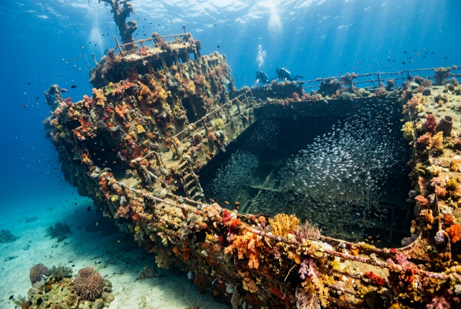
SS Yongala — illustrative image

SS Yongala

Australian coastal passenger and cargo steamer تاريخ الغرق 1911 14–28 m Townsville & the Yongala
رسم توضيحي من الذكاء الاصطناعي التوليدي
فُقدت أرواح هناAll 122 aboard died. يطلب المشغّلون المحليون أن يُغاص عند الحطام باحترام مماثل.
موثّق جيداً
العمق إلى السطح العلوي
14 m / 46 ft
الحد الأقصى للعمق
28 m / 92 ft
بُني / أُغرق
1903 / 1911
الطول
110 m
الحمولة
3,664 GRT
نظرة عامة
On Her Starboard Side
المستوى
Advanced
أفضل الأشهر
Aug–Dec

القصة

The Yongala was a crack coastal liner, English-built in 1903 and running the Adelaide–Cairns route for the Adelaide Steamship Company. On 23 March 1911 she steamed north past the Dent Island lighthouse into a cyclone; wireless had been invented but her set had not yet been fitted, so the storm warning could not reach her. She vanished with all 122 people aboard — passengers, crew, and a racehorse named Moonshine whose body coming ashore was among the first evidence of the loss. For decades her fate stayed one of Australia's sea mysteries; a wartime sonar contact was finally confirmed as the Yongala in 1958. She lies on her starboard side on open sand miles from any reef, and that isolation made her an oasis: half a century of larvae drifting past had nowhere else to settle, and she is now routinely called the most life-dense wreck dive on earth. She is also a mass grave, protected by law, dived outside only.

كيف غرقت: Lost with all hands in a cyclone off Cape Bowling Green, 23 March 1911.

الغوص فيها اليوم

الحالة: Protected since 1981 under Australia's Historic Shipwrecks Act 1976, now the Underwater Cultural Heritage Act 2018: the hull is intact but softening, and divers are barred from entering or touching it. Moorings are mandatory; anchoring is banned.

الغوص في الأماكن الضيقة (Penetration): None. Entry is prohibited by law under her protected-zone status — and unnecessary: everything that makes this dive extraordinary lives on the outside.

الشهادة الموصى بها: Advanced Open Water

التيار: Strong · الرؤية: 8–20 m

الحياة البحرية: Giant Queensland groupers, marble rays stacked under the bow, olive sea snakes, turtles, eagle rays, barracuda, snapper in walls, and trevally storms — with bull sharks passing in the cooler months.

المخاطر: Open-ocean current that can run hard the full dive, exposed sea conditions on the crossing, and no sheltering reef; this is a strong-skills dive.

الحماية والتشريعات

Commonwealth protected zone under the Underwater Cultural Heritage Act 2018; access via permitted operators and fixed moorings only.

She is the grave of 122 people; penetration, artifact disturbance, and anchoring are offenses.

Nothing may be touched or taken — the law and the dead both say so.

شاهد

من القنوات الرسمية

جميع الفيديوهات →

مقاطع الفيديو روابط مضمّنة لقنوات أصحابها أنفسهم — لا نستضيف شيئاً ونُشير إلى المصدر دائماً.

المصادر: Queensland Museum Network ↗Wikipedia ↗ · المعلومات مُتحقَّق منها وفق المصادر أعلاه؛ والحقول غير المدعومة بمصدر مُصنَّفة بـ "لم يُتحقَّق منه بعد".

أستراليا، نيوزيلندا وشرق آسيا

Cairns & the Ribbon ReefsNingaloo ReefCoral Sea & Osprey ReefOkinawa & the Kerama IslandsPoor Knights IslandsTownsville & the YongalaGreen IslandIzu Peninsula

البحر الكاريبي وغرب المحيط الأطلسي

BonaireCozumelRiviera Maya & the CenotesBelize Barrier ReefGrand CaymanIsla Mujeres & CancúnRoatánTiger Beach & Grand Bahama

أوروبا والأطلسي والمتوسط

Malta & GozoSilfra & IcelandThe AzoresCanary IslandsLarnaca & the ZenobiaScapa FlowArctic NorwayMadeira

المحيط الهندي وشرق أفريقيا

North & South Malé AtollsAri AtollBaa Atoll & Hanifaru BayAliwal Shoal & UmkomaasMafia IslandMauritiusSeychellesSodwana Bay

جزر المحيط الهادئ وميكرونيزيا

PalauChuuk (Truk) LagoonFakaravaKona, HawaiʻiRangiroaTaveuni & Rainbow ReefBeqa Lagoon & Pacific HarbourEspiritu Santo

البحر الأحمر والشرق الأوسط

Sharm El Sheikh & Ras MohammedBrothers, Daedalus & St John'sDahabHurghada & El GounaMarsa Alam & the Deep SouthAqabaDaymaniyat IslandsMusandam Peninsula

جنوب شرق آسيا ومثلث الشعاب المرجانية

Bali & Nusa PenidaKomodoRaja AmpatSipadan & MabulAnilaoCoronKoh TaoLembeh Strait

الأمريكتان والمحيط الهادئ الشرقي

Galápagos IslandsCocos IslandFlorida KeysSea of Cortez & Cabo PulmoSocorro & the RevillagigedosBritish ColumbiaCalifornia Channel IslandsCosta Rica Pacific Coast