Duiksites, seizoenen en zeeleven — onderzocht, in kaart gebracht, gepland.
Menu
Bestemmingen Duiklocaties Zeeleven Wrakken Nieuws
Plan een reis Reisplanner Wanneer duiken Kostencalculator Vergelijkingen Zeeleven-kalender Watertemperatuur Liveaboards Operators & resorts Mariene parken Hyperbare kamers Wereldkaart
Regio's Australië, Nieuw-Zeeland & Oost-AziëCaribisch gebied & westelijke Atlantische OceaanEuropa, Atlantische Oceaan & Middellandse ZeeIndische Oceaan & Oost-AfrikaPacifische eilanden & MicronesiëRode Zee & Midden-OostenZuidoost-Azië & Coral TriangleDe Amerika's & Oost-Stille Oceaan Landen
Leren & Tools Alle gidsen Brevetten Uitrustingsgidsen Video's Vraag de data AI-agents API
Over Over ons Methodologie Disclaimer Contact
Jouw weergave
★ Opgeslagen

Jouw favoriete bestemmingen, duiklocaties en soorten — opgeslagen in deze browser.

API GATEWAY

Gratis alleen-lezen JSON-toegang tot de gecachede data van de atlas.

Donkere modus

🧭 Begeleide weergave
Nieuw met duiken — dieptes, stromingen, brevetniveaus? We leggen elke term uit terwijl je bladert, in gewone taal. Dezelfde gegevens, met ingebouwde uitleg.

⚡ Expertweergave
Je weet het verschil tussen een wand en een drift dive al. Alleen de data — overzichtelijk, snel en compact. Dit is de standaardweergave.

Interfacetaal
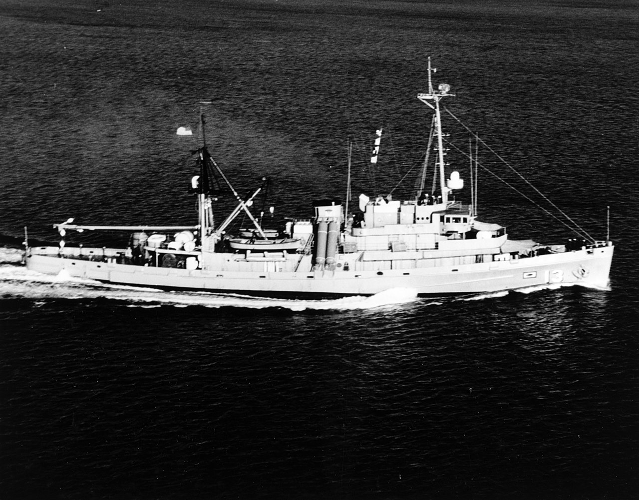
USS Kittiwake — illustrative image

USS Kittiwake

Chanticleer-class submarine rescue vessel (ASR-13) Gezonken 2011 5–19 m Grand Cayman
AI-gegenereerde illustratie
Er zijn levens verloren gegaanNone (planned scuttling). Lokale operators verzoeken het wrak met gepast respect te duiken.
Goed gedocumenteerd
Diepte tot dek
5 m / 16 ft
Maximale diepte
19 m / 62 ft
Gebouwd / gezonken
1945 / 2011
Lengte
76 m
Oriëntatie
Port Side (Upright Until 2017 Storm Swells)
Niveau
Beginner
Beste maanden
Nov–May

Het verhaal

For almost fifty years the Kittiwake tended US Navy submarines, her divers and recompression chambers standing by for crews in trouble; her boats also recovered the data recorder from the Challenger space shuttle wreckage in 1986. Decommissioned in 1994, she spent years in the mothball fleet before the Cayman Islands bought her for a purpose she was oddly suited to: teaching divers. Stripped of fuel, wiring and hazards, with hatches removed and hull openings cut, she was sent down in clear sand off the north end of Seven Mile Beach in January 2011 and has been colonizing ever since. She originally sat upright and so shallow that snorkelers could study her deck; heavy storm swells in 2017 rolled her onto her port side, where she remains, largely intact. Five decks — mess hall, recompression chamber, mirrors still on bulkheads — make her one of the world's most accessible true ship interiors, while the surrounding sand flat keeps navigation simple. A small fee, collected through operators, funds her upkeep as a managed dive attraction.

Hoe ze zonk: Deliberately scuttled as an artificial reef off Seven Mile Beach, 5 January 2011.

Duik er vandaag in

Conditie: Intact and clean; lying on her port side since 2017 with structure sound and interior spaces open

Penetratieduiken: Full With Training. Prepared for diver access with cut openings and removed hatches; upper compartments are bright and simple, but full interior tours still call for wreck training and a guide who knows the new sideways geometry. Het betreden van elke overhead-omgeving vereist specifieke training — minimaal een wrakduikcertificaat, technische wraktraining voor volledige penetratie.

Aanbevolen certificering: Open Water

Stroming: Mild · Zicht: 20–30 m

Zeeleven: Horse-eye jacks school over the hull, garden eels ring the sand, hawksbill turtles graze the sponges, and barracuda, goatfish and the occasional spotted eagle ray pass along the reef line.

Gevaren: Light surge in winter swells; inside, the rotated orientation disorients divers who knew her upright

Bescherming & wetgeving

Managed wreck site under Cayman marine-park rules — a small dive fee applies through licensed operators and nothing may be taken

Bekijk

Via de officiële kanalen

Alle video's →

Video's zijn ingesloten links naar de kanalen van de makers zelf — wij hosten niets en vermelden altijd de bron.

Bronnen: Cayman Islands Government ↗Wikipedia ↗ · Feiten geverifieerd aan de hand van bovenstaande bronnen; velden zonder onderbouwing zijn aangemerkt als nog niet geverifieerd.

Australië, Nieuw-Zeeland & Oost-Azië

Cairns & the Ribbon ReefsNingaloo ReefCoral Sea & Osprey ReefOkinawa & the Kerama IslandsPoor Knights IslandsTownsville & the YongalaGreen IslandIzu Peninsula

Caribisch gebied & westelijke Atlantische Oceaan

BonaireCozumelRiviera Maya & the CenotesBelize Barrier ReefGrand CaymanIsla Mujeres & CancúnRoatánTiger Beach & Grand Bahama

Europa, Atlantische Oceaan & Middellandse Zee

Malta & GozoSilfra & IcelandThe AzoresCanary IslandsLarnaca & the ZenobiaScapa FlowArctic NorwayMadeira

Indische Oceaan & Oost-Afrika

North & South Malé AtollsAri AtollBaa Atoll & Hanifaru BayAliwal Shoal & UmkomaasMafia IslandMauritiusSeychellesSodwana Bay

Pacifische eilanden & Micronesië

PalauChuuk (Truk) LagoonFakaravaKona, HawaiʻiRangiroaTaveuni & Rainbow ReefBeqa Lagoon & Pacific HarbourEspiritu Santo

Rode Zee & Midden-Oosten

Sharm El Sheikh & Ras MohammedBrothers, Daedalus & St John'sDahabHurghada & El GounaMarsa Alam & the Deep SouthAqabaDaymaniyat IslandsMusandam Peninsula

Zuidoost-Azië & Coral Triangle

Bali & Nusa PenidaKomodoRaja AmpatSipadan & MabulAnilaoCoronKoh TaoLembeh Strait

De Amerika's & Oost-Stille Oceaan

Galápagos IslandsCocos IslandFlorida KeysSea of Cortez & Cabo PulmoSocorro & the RevillagigedosBritish ColumbiaCalifornia Channel IslandsCosta Rica Pacific Coast