اكتشف أين تغوص، ومتى تذهب، وما الذي يمكن أن تراه.

اكتشف أين تغوص، ومتى تذهب، وما الذي يمكن أن تراه.
★
القائمة
الوجهات مواقع الغوص الحياة البحرية حطام السفن الأخبار
خطّط لرحلة مخطّط الرحلات أفضل أوقات الغوص حاسبة التكاليف مقارنات تقويم الحياة البحرية درجة حرارة الماء الليفبوردات المشغّلون والمنتجعات المحميات البحرية غرف الضغط العالي خريطة العالم
الغوص في الكهوف جميع غطسات الكهوف الوجهات ومواقع الغوص أنظمة الكهوف والخرائط التدريب والمؤهلات مراكز الغوص والمرشدون المعدات والتكنولوجيا أبحاث السلامة والحوادث العلوم والتاريخ والحفاظ على البيئة الموارد والتحديثات
المناطق أستراليا، نيوزيلندا وشرق آسياالبحر الكاريبي وغرب المحيط الأطلسيأوروبا والأطلسي والمتوسطالمحيط الهندي وشرق أفريقياجزر المحيط الهادئ وميكرونيزياالبحر الأحمر والشرق الأوسطجنوب شرق آسيا ومثلث الشعاب المرجانيةالأمريكتان والمحيط الهادئ الشرقي الدول
التعلّم والأدوات جميع الأدلة الشهادات أدلة المعدات مقاطع فيديو استفسر عن البيانات وكلاء الذكاء الاصطناعي API
حول من نحن المنهجية إخلاء المسؤولية تواصل معنا
عرضك
★ محفوظ

وجهاتك وموقعك ومواقع الأنواع المحفوظة بالنجوم، مخزّنة في هذا المتصفح.

API GATEWAY

وصول JSON مجاني للقراءة فقط إلى البيانات المخزّنة في الأطلس.

الوضع الداكن

عرض المرشد
جديد على الغطس؟ الأعماق والتيارات ومستويات الشهادات؟ نشرح كل مصطلح أثناء تصفّحك بلغة واضحة. نفس البيانات، مع الشرح مدمجاً.

عرض الخبراء
أنت تعرف أصلًا الفرق بين الجدار وال drift dive. إليك البيانات فقط: واضحة وسريعة ومختصرة. هذا هو العرض الافتراضي.

لغة الواجهة
USAT Liberty

USAT Liberty

US Army transport ship (First World War-era cargo steamer) تاريخ الغرق 1963 5–30 m Bali & Nusa Penida
الصورة: G patkar · CC BY-SA 3.0
لم تُسجَّل هنا أي خسائر في الأرواحNone: the crew survived the 1942 attack.
موثّق جيداً
العمق إلى السطح العلوي
5 m / 16 ft
الحد الأقصى للعمق
30 m / 98 ft
بُني / أُغرق
1918 / 1963
الطول
120 m
نظرة عامة
On Her Side Along The Slope, Heavily Collapsed
المستوى
Beginner
أفضل الأشهر
Apr–Nov

القصة

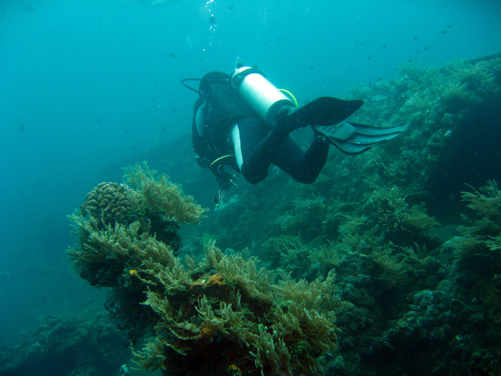
The Liberty is the world's most visited shipwreck largely because you can walk to her. Built in 1918 as a US wartime freighter, she was crossing the Lombok Strait in January 1942 with railway parts and rubber when the Japanese submarine I-166 torpedoed her. Two Allied destroyers took the flooding ship in tow, but she could not make Singaraja and was run ashore at Tulamben on Bali's northeast coast, where she was stripped and left rusting on the black sand for twenty years. In 1963 the catastrophic eruption of Mount Agung, whose cone rises directly behind the beach, shook her off the shore, and she slid to rest on the sand slope a stone's throw out, from snorkel depth to thirty meters. Six decades of warm, nutrient-rich water have done the rest: the broken hull is now Bali's densest reef, circled at dawn by a famous school of bumphead parrotfish. Guides, porters, and warungs in Tulamben village all live on her patronage.

كيف غرقت: Torpedoed by Japanese submarine I-166 on 11 January 1942 and beached at Tulamben; tremors from the 1963 eruption of Mount Agung slid the hull below the waterline.

الغوص فيها اليوم

الحالة: A ruin in the best sense: structural collapse has opened her to light and growth, and coral now holds much of her shape together.

الغوص في الأماكن الضيقة (Penetration): Limited. Openings in the collapsed hull allow short daylight swim-throughs; there is no deep interior left to penetrate. الدخول إلى أي بيئة مغلقة يستلزم تدريباً متخصصاً: شهادة الحطام كحدٍّ أدنى، والتدريب التقني على الحطام للاختراق الكامل.

الشهادة الموصى بها: Open Water

التيار: Mild · الرؤية: 10–25 m

الحياة البحرية: Bumphead parrotfish at first light, resident great barracuda, garden eels on the slope, pygmy seahorses on the gorgonians, and clouds of anthias over every surface.

المخاطر: Crowds at peak hours, surge on the shallow section in season, and stonefish and scorpionfish on the entry rocks.

الحماية والتشريعات

The village community manages the site; fees and porter customs support local stewardship.

Nothing has been left to take, and nothing on the reef may be.

شاهد

من القنوات الرسمية

جميع الفيديوهات →

مقاطع الفيديو روابط مُضمَّنة لقنوات أصحابها. لا نستضيف شيئًا ونُشير إلى المصدر في كل الأحوال.

المصادر: Wikipedia ↗Scientific Reports (Nature Portfolio) ↗ · المعلومات مُتحقَّق منها وفق المصادر أعلاه؛ والحقول غير المدعومة بمصدر مُصنَّفة بـ "لم يُتحقَّق منه بعد".

أستراليا، نيوزيلندا وشرق آسيا

Cairns & the Ribbon ReefsNingaloo ReefCoral Sea & Osprey ReefOkinawa & the Kerama IslandsPoor Knights IslandsTownsville & the YongalaGreen IslandIzu Peninsula

البحر الكاريبي وغرب المحيط الأطلسي

BonaireCozumelRiviera Maya & the CenotesBelize Barrier ReefGrand CaymanIsla Mujeres & CancúnRoatánTiger Beach & Grand Bahama

أوروبا والأطلسي والمتوسط

Malta & GozoSilfra & IcelandThe AzoresCanary IslandsLarnaca & the ZenobiaScapa FlowArctic NorwayMadeira

المحيط الهندي وشرق أفريقيا

North & South Malé AtollsAri AtollBaa Atoll & Hanifaru BayAliwal Shoal & UmkomaasMafia IslandMauritiusSeychellesSodwana Bay

جزر المحيط الهادئ وميكرونيزيا

PalauChuuk (Truk) LagoonFakaravaKona, HawaiʻiRangiroaTaveuni & Rainbow ReefBeqa Lagoon & Pacific HarbourEspiritu Santo

البحر الأحمر والشرق الأوسط

Sharm El Sheikh & Ras MohammedBrothers, Daedalus & St John'sDahabHurghada & El GounaMarsa Alam & the Deep SouthAqabaDaymaniyat IslandsMusandam Peninsula

جنوب شرق آسيا ومثلث الشعاب المرجانية

Bali & Nusa PenidaKomodoRaja AmpatSipadan & MabulAnilaoCoronKoh TaoLembeh Strait

الأمريكتان والمحيط الهادئ الشرقي

Galápagos IslandsCocos IslandFlorida KeysSea of Cortez & Cabo PulmoSocorro & the RevillagigedosBritish ColumbiaCalifornia Channel IslandsCosta Rica Pacific Coast