مواقع الغوص والمواسم والحياة البحرية — مبحوثة، ومرسومة على الخرائط، ومخطَّط لها.
القائمة
الوجهات مواقع الغوص الحياة البحرية حطام السفن الأخبار
خطّط لرحلة مخطّط الرحلات أفضل أوقات الغوص حاسبة التكاليف مقارنات تقويم الحياة البحرية درجة حرارة الماء الليفبوردات المشغّلون والمنتجعات المحميات البحرية غرف الضغط العالي خريطة العالم
المناطق أستراليا، نيوزيلندا وشرق آسياالبحر الكاريبي وغرب المحيط الأطلسيأوروبا والأطلسي والمتوسطالمحيط الهندي وشرق أفريقياجزر المحيط الهادئ وميكرونيزياالبحر الأحمر والشرق الأوسطجنوب شرق آسيا ومثلث الشعاب المرجانيةالأمريكتان والمحيط الهادئ الشرقي الدول
التعلّم والأدوات جميع الأدلة الشهادات أدلة المعدات مقاطع فيديو استفسر عن البيانات وكلاء الذكاء الاصطناعي API
حول من نحن المنهجية إخلاء المسؤولية تواصل معنا
عرضك
★ محفوظ

وجهاتك المفضّلة والمواقع والكائنات البحرية المُعلَّمة بنجمة — محفوظة في هذا المتصفح.

API GATEWAY

وصول JSON مجاني للقراءة فقط إلى البيانات المخزّنة في الأطلس.

الوضع الداكن

🧭 عرض المرشد
هل أنت جديد على الغوص — أعماق، تيارات، مستويات شهادات؟ نشرح كل مصطلح أثناء تصفّحك، بأسلوب بسيط وواضح. نفس البيانات، مع المساعدة المدمجة فيها.

⚡ عرض الخبراء
أنت تعرف الفرق بين الجدار والدريفت دايف. فقط البيانات — واضحة وسريعة ومختصرة. هذا هو العرض الافتراضي.

لغة الواجهة
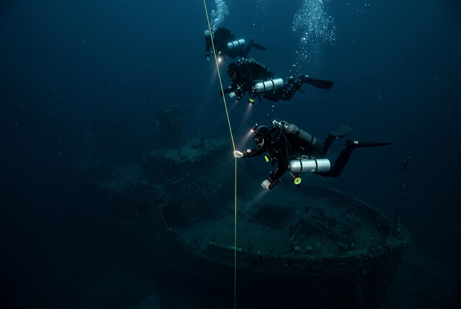
USS Saratoga — illustrative image

USS Saratoga

US Navy fleet aircraft carrier (CV-3) تاريخ الغرق 1946 18–51 m Bikini Atoll
رسم توضيحي من الذكاء الاصطناعي التوليدي
فُقدت أرواح هناNone in the sinking — the target fleet was unmanned. يطلب المشغّلون المحليون أن يُغاص عند الحطام باحترام مماثل.
موثّق جيداً
العمق إلى السطح العلوي
18 m / 59 ft
الحد الأقصى للعمق
51 m / 167 ft
بُني / أُغرق
1927 / 1946
الطول
270 m
نظرة عامة
Upright
المستوى
Advanced
أفضل الأشهر
May–Oct

القصة

Laid down as a battlecruiser and finished as a carrier under the Washington Treaty, Saratoga was one of the ships that taught the US Navy carrier aviation. Commissioned in 1927, she fought across the Pacific war — torpedoed twice, struck by kamikazes off Iwo Jima with heavy loss of life, repaired every time — and ended the war as the fleet's grand old lady. That pedigree earned her no reprieve: assigned as a target for Operation Crossroads at Bikini in 1946, she rode out the Able air burst on 1 July, then took the full force of the Baker underwater shot on 25 July, which lifted her stern and broke her. She sank unmanned about seven and a half hours later, settling upright on the lagoon floor. She is the only aircraft carrier most divers will ever have a realistic chance to visit: flight deck within sport depths, aircraft and bombs still in the hangar, an island looming in blue water. Reaching her means a remote technical-style expedition, and that is part of her spell.

كيف غرقت: Sunk by the underwater Baker atomic test of Operation Crossroads, 25 July 1946.

الغوص فيها اليوم

الحالة: Imposing and largely intact, though the island and flight deck have sagged in places as decades pass. Residual radioactivity at diver depths measures low on modern surveys, and expeditions brief on it — the radiological story is history more than hazard, but it is briefed for a reason.

الغوص في الأماكن الضيقة (Penetration): Full With Training. Hangar-deck and interior routes are dived by technical teams with lights and lines; the sheer scale means lost-diver risk is real without discipline. الدخول إلى أي بيئة محاطة يستلزم تدريبًا متخصصًا — شهادة الحطام كحدٍّ أدنى، والتدريب التقني على الاختراق الكامل للحطام عند الرغبة في الاستكشاف الكامل.

الشهادة الموصى بها: Advanced/deep certification for the flight deck; technical training for interiors and depth

التيار: Mild · الرؤية: 20–35 m

الحياة البحرية: Anemones and sponges on the island, snappers and squirrelfish in the hangar shadows, grey reef sharks over the flight deck.

المخاطر: Remote location days from a chamber; depth and overheads; live ordnance aboard; commit conservatively.

الحماية والتشريعات

Bikini Atoll is a UNESCO World Heritage Site; diving runs only through authorized expedition arrangements with local approval, and fees support the displaced Bikinian community.

A heritage site and a nuclear-history monument — nothing leaves the lagoon.

شاهد

من القنوات الرسمية

جميع الفيديوهات →

مقاطع الفيديو روابط مضمّنة لقنوات أصحابها أنفسهم — لا نستضيف شيئاً ونُشير إلى المصدر دائماً.

المصادر: UNESCO World Heritage Centre ↗Wikipedia ↗ · المعلومات مُتحقَّق منها وفق المصادر أعلاه؛ والحقول غير المدعومة بمصدر مُصنَّفة بـ "لم يُتحقَّق منه بعد".

أستراليا، نيوزيلندا وشرق آسيا

Cairns & the Ribbon ReefsNingaloo ReefCoral Sea & Osprey ReefOkinawa & the Kerama IslandsPoor Knights IslandsTownsville & the YongalaGreen IslandIzu Peninsula

البحر الكاريبي وغرب المحيط الأطلسي

BonaireCozumelRiviera Maya & the CenotesBelize Barrier ReefGrand CaymanIsla Mujeres & CancúnRoatánTiger Beach & Grand Bahama

أوروبا والأطلسي والمتوسط

Malta & GozoSilfra & IcelandThe AzoresCanary IslandsLarnaca & the ZenobiaScapa FlowArctic NorwayMadeira

المحيط الهندي وشرق أفريقيا

North & South Malé AtollsAri AtollBaa Atoll & Hanifaru BayAliwal Shoal & UmkomaasMafia IslandMauritiusSeychellesSodwana Bay

جزر المحيط الهادئ وميكرونيزيا

PalauChuuk (Truk) LagoonFakaravaKona, HawaiʻiRangiroaTaveuni & Rainbow ReefBeqa Lagoon & Pacific HarbourEspiritu Santo

البحر الأحمر والشرق الأوسط

Sharm El Sheikh & Ras MohammedBrothers, Daedalus & St John'sDahabHurghada & El GounaMarsa Alam & the Deep SouthAqabaDaymaniyat IslandsMusandam Peninsula

جنوب شرق آسيا ومثلث الشعاب المرجانية

Bali & Nusa PenidaKomodoRaja AmpatSipadan & MabulAnilaoCoronKoh TaoLembeh Strait

الأمريكتان والمحيط الهادئ الشرقي

Galápagos IslandsCocos IslandFlorida KeysSea of Cortez & Cabo PulmoSocorro & the RevillagigedosBritish ColumbiaCalifornia Channel IslandsCosta Rica Pacific Coast