Ontdek waar je kunt duiken, wanneer je moet gaan en wat je zou kunnen zien.

Ontdek waar je kunt duiken, wanneer je moet gaan en wat je zou kunnen zien.
★
Menu
Bestemmingen Duiklocaties Zeeleven Wrakken Nieuws
Plan een reis Reisplanner Wanneer duiken Kostencalculator Vergelijkingen Zeeleven-kalender Watertemperatuur Liveaboards Operators & resorts Mariene parken Hyperbare kamers Wereldkaart
Grotduiken Alle grotduiken Bestemmingen & duiklocaties Grottenstelsels en kaarten Training & Kwalificaties Duikcentra & gidsen Uitrusting & technologie Veiligheid & incidentonderzoek Wetenschap, geschiedenis & natuurbehoud Bronnen & updates
Regio's Australië, Nieuw-Zeeland & Oost-AziëCaribisch gebied & westelijke Atlantische OceaanEuropa, Atlantische Oceaan & Middellandse ZeeIndische Oceaan & Oost-AfrikaPacifische eilanden & MicronesiëRode Zee & Midden-OostenZuidoost-Azië & Coral TriangleDe Amerika's & Oost-Stille Oceaan Landen
Leren & Tools Alle gidsen Brevetten Uitrustingsgidsen Video's Vraag de data AI-agents API
Over Over ons Methodologie Disclaimer Contact
Jouw weergave
★ Opgeslagen

Je favoriete bestemmingen, duikplekken en soorten, opgeslagen in deze browser.

API GATEWAY

Gratis alleen-lezen JSON-toegang tot de gecachede data van de atlas.

Donkere modus

Begeleide weergave
Nieuw met duiken? Dieptes, stromingen, brevetniveaus? We leggen elke term uit terwijl je bladert, in gewone taal. Dezelfde gegevens, met ingebouwde uitleg.

Expertweergave
Je kent het verschil tussen een wall en een drift dive al. Alleen de data: overzichtelijk, snel en compact. Dit is de standaardweergave.

Interfacetaal
YO-257

YO-257

US Navy self-propelled yard oiler Gezonken 1989 21–30 m Oʻahu
AI-gegenereerde illustratie
Hier zijn geen levens verloren gegaanNone (planned scuttling).
Gedocumenteerd
Diepte tot dek
21 m / 69 ft
Maximale diepte
30 m / 98 ft
Gebouwd / gezonken
? / 1989
Lengte
53 m
Oriëntatie
Upright
Niveau
Intermediate
Beste maanden
Year-round

Het verhaal

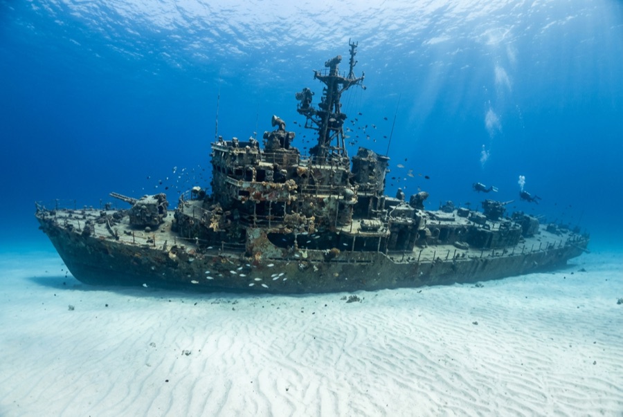
For decades this plain workboat carried fuel around Pearl Harbor's piers, one of the unglamorous yard oilers that kept the fleet running from the Second World War era onward. Her second act is far more public. Purchased by Atlantis Submarines and scuttled off Waikiki in 1989, the roughly 53-meter YO-257 was placed specifically to give the company's tourist submarines something to circle, which means divers on her deck routinely look up to find a 48-passenger submarine gliding past, faces pressed to the portholes, everyone waving at everyone. She sits upright on a flat sand bottom at about 30 meters, cut with large access openings, her rails thick with encrusting growth. Green sea turtles treat the wreck as a rest stop and can be found dozing on the deck plates; whitetip reef sharks tuck under the hull; bluestripe snapper, the introduced taape, swarm the superstructure in yellow rivers. A second wreck, the smaller San Pedro, lies within an easy swim, and most operators run the pair as one dive. As an easy, animal-rich introduction to Hawaiian wreck diving, she has few rivals.

Hoe ze zonk: Deliberately scuttled as an artificial reef off Waikiki, 1989.

Duik er vandaag in

Conditie: Upright and intact, heavily encrusted; access cuts keep the structure open and bright

Penetratieduiken: Limited. Large cut openings allow straightforward swim-throughs of the main spaces; overhead time is short and well lit, but training still applies. Het betreden van een omgeving met overhead vereist specifieke training: minimaal een wrakbrevet, technische wraktraining voor volledige penetratie.

Aanbevolen certificering: Advanced Open Water

Stroming: Mild · Zicht: 15–30 m

Zeeleven: Resting green turtles, whitetip reef sharks under the stern, clouds of bluestripe snapper, spotted eagle rays over the sand, and octopus in the fittings.

Gevaren: Submarine traffic overhead: stay with the wreck and your group; depth on the sand

Bekijk

Via de officiële kanalen

Alle video's →

Video's zijn ingesloten links naar de eigen kanalen van de makers. We hosten niets en vermelden altijd de bron.

Bronnen: Hawaiʻi Department of Land and Natural Resources ↗ · Feiten geverifieerd aan de hand van bovenstaande bronnen; velden zonder onderbouwing zijn aangemerkt als nog niet geverifieerd.

Australië, Nieuw-Zeeland & Oost-Azië

Cairns & the Ribbon ReefsNingaloo ReefCoral Sea & Osprey ReefOkinawa & the Kerama IslandsPoor Knights IslandsTownsville & the YongalaGreen IslandIzu Peninsula

Caribisch gebied & westelijke Atlantische Oceaan

BonaireCozumelRiviera Maya & the CenotesBelize Barrier ReefGrand CaymanIsla Mujeres & CancúnRoatánTiger Beach & Grand Bahama

Europa, Atlantische Oceaan & Middellandse Zee

Malta & GozoSilfra & IcelandThe AzoresCanary IslandsLarnaca & the ZenobiaScapa FlowArctic NorwayMadeira

Indische Oceaan & Oost-Afrika

North & South Malé AtollsAri AtollBaa Atoll & Hanifaru BayAliwal Shoal & UmkomaasMafia IslandMauritiusSeychellesSodwana Bay

Pacifische eilanden & Micronesië

PalauChuuk (Truk) LagoonFakaravaKona, HawaiʻiRangiroaTaveuni & Rainbow ReefBeqa Lagoon & Pacific HarbourEspiritu Santo

Rode Zee & Midden-Oosten

Sharm El Sheikh & Ras MohammedBrothers, Daedalus & St John'sDahabHurghada & El GounaMarsa Alam & the Deep SouthAqabaDaymaniyat IslandsMusandam Peninsula

Zuidoost-Azië & Coral Triangle

Bali & Nusa PenidaKomodoRaja AmpatSipadan & MabulAnilaoCoronKoh TaoLembeh Strait

De Amerika's & Oost-Stille Oceaan

Galápagos IslandsCocos IslandFlorida KeysSea of Cortez & Cabo PulmoSocorro & the RevillagigedosBritish ColumbiaCalifornia Channel IslandsCosta Rica Pacific Coast