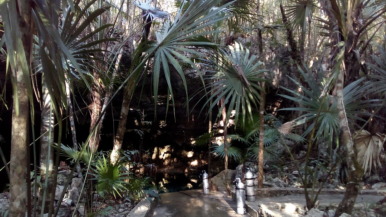
Cenote Tajma Ha
Level 2 - Intermediate: CREER cenote level (guided cavern diving) [1] [2] (Cavern tours marked 'not recommended' since 2024-02-27 because of sediment.). Training drills permitted on listed lines: CREER approved cave training site [3] (Jumna River line, Sagrado line, Mangrovia line and the cavern zone.). Deze categorieën komen uit het genoemde systeem zelf; ze beschrijven de opleiding die een locatie vereist.
Entrance to Sistema Taj Mahal south of Puerto Aventuras, known for light beams and a dense halocline; CREER rates it Level 2 but advised against cavern tours from February 2024 because of sediment from a nearby excavation.
Tajma Ha is the dive entrance to Sistema Taj Mahal, about 5 km south of Puerto Aventuras according to Pro Dive International. The cavern route passes beneath an air-filled bat chamber to a second, smaller opening called the Sugar Bowl, where sunlight enters in beams, and deeper areas cross a halocline. Operators also describe fossil shells in the walls.
CREER rates Tajma Ha Level 2 (Intermediate) for guided cavern diving, and several of its lines (Jumna River, Sagrado, Mangrovia and the cavern zone) are approved CREER training locations. On 27 February 2024 CREER noted that the cavern line had become unsafe because of excess sediment after the excavation of nearby Cenote Esmeralda and marked cavern tours as not recommended; cave diving remained open. CREER repeated in April 2024 that recreational cenote tours should not be run there.
De omgeving
Shallow cavern with skylights, a bat-roost air chamber and a halocline in deeper sections.
Omstandigheden
A dense halocline in deeper areas; since 2024 CREER has reported excess sediment in the cavern zone. Typical conditions only.
Gebruikelijke ranges uit gepubliceerde bronnen, geen actuele omstandigheden.
Voor oriëntatie, niet voor navigatie. Holle stippen zijn bij benadering.
Elk gegeven op deze pagina, met zijn bron (9)
| Gegeven | Status | Bron |
|---|---|---|
| CREER rates Tajma Ha as Level 2 (Intermediate). | Geverifieerd | [1] [2] |
| On 2024-02-27 CREER noted the Tajma Ha cavern line was unsafe due to excess sediment after the excavation of Cenote Esmeralda, marked cavern tours as not recommended and listed cave diving as open.Viewed 2026-10-14; may since have changed. | Geverifieerd | [1] |
| CREER's April 2024 update said cenote tours for recreational divers should not be run at Tajma-Ha because of heavy sediment in the cavern zone from the excavation. | Geverifieerd | [6] |
| CREER's training rules list the Jumna River line, Sagrado line, Mangrovia line and cavern zone at Tajma Ha among approved training locations.Rules dated 2020-12-14. | Geverifieerd | [3] |
| Pro Dive International places Tajma Ha about 5 km south of Puerto Aventuras and 26 km south of Playa del Carmen. | Gemeld | [5] |
| Pro Dive International describes a cavern route beneath an air-filled bat cave to a smaller cenote called the Sugar Bowl, light beams, fossils and haloclines in deeper areas. | Gemeld | [5] |
| Under the Jungle says it is located at the entrance to Cenote Tajma Ha. | Gemeld | [7] |
| CREER Level 2 requires the Level 1 requirements plus a previous Level 1 cenote dive, with at most 4 divers per guide. | Geverifieerd | [2] |
| CREER says single-tank cavern diving is allowed only at designated cavern sites under a qualified local guide, and that divers without cave training must not be taken into the cavern zone of caves that are not designated cavern tour sites.CREER guidance dated 2025-06-20. | Geverifieerd | [4] |
Geverifieerd: vermeld door een officiële of primaire bron die we hebben geraadpleegd. Gemeld: alleen afkomstig van een secundaire bron. Bronnen spreken elkaar tegen: de noot geeft beide versies. Mogelijk verouderd: de nieuwste bron die we hebben gevonden is oud.
In eigen woorden geschreven op basis van bovenstaande bronnen. Een correctie melden