Ontdek waar je kunt duiken, wanneer je moet gaan en wat je zou kunnen zien.

Ontdek waar je kunt duiken, wanneer je moet gaan en wat je zou kunnen zien.
★
Menu
Bestemmingen Duiklocaties Zeeleven Wrakken Nieuws
Plan een reis Reisplanner Wanneer duiken Kostencalculator Vergelijkingen Zeeleven-kalender Watertemperatuur Liveaboards Operators & resorts Mariene parken Hyperbare kamers Wereldkaart
Grotduiken Alle grotduiken Bestemmingen & duiklocaties Grottenstelsels en kaarten Training & Kwalificaties Duikcentra & gidsen Uitrusting & technologie Veiligheid & incidentonderzoek Wetenschap, geschiedenis & natuurbehoud Bronnen & updates
Regio's Australië, Nieuw-Zeeland & Oost-AziëCaribisch gebied & westelijke Atlantische OceaanEuropa, Atlantische Oceaan & Middellandse ZeeIndische Oceaan & Oost-AfrikaPacifische eilanden & MicronesiëRode Zee & Midden-OostenZuidoost-Azië & Coral TriangleDe Amerika's & Oost-Stille Oceaan Landen
Leren & Tools Alle gidsen Brevetten Uitrustingsgidsen Video's Vraag de data AI-agents API
Over Over ons Methodologie Disclaimer Contact
Jouw weergave
★ Opgeslagen

Je favoriete bestemmingen, duikplekken en soorten, opgeslagen in deze browser.

API GATEWAY

Gratis alleen-lezen JSON-toegang tot de gecachede data van de atlas.

Donkere modus

Begeleide weergave
Nieuw met duiken? Dieptes, stromingen, brevetniveaus? We leggen elke term uit terwijl je bladert, in gewone taal. Dezelfde gegevens, met ingebouwde uitleg.

Expertweergave
Je kent het verschil tussen een wall en een drift dive al. Alleen de data: overzichtelijk, snel en compact. Dit is de standaardweergave.

Interfacetaal
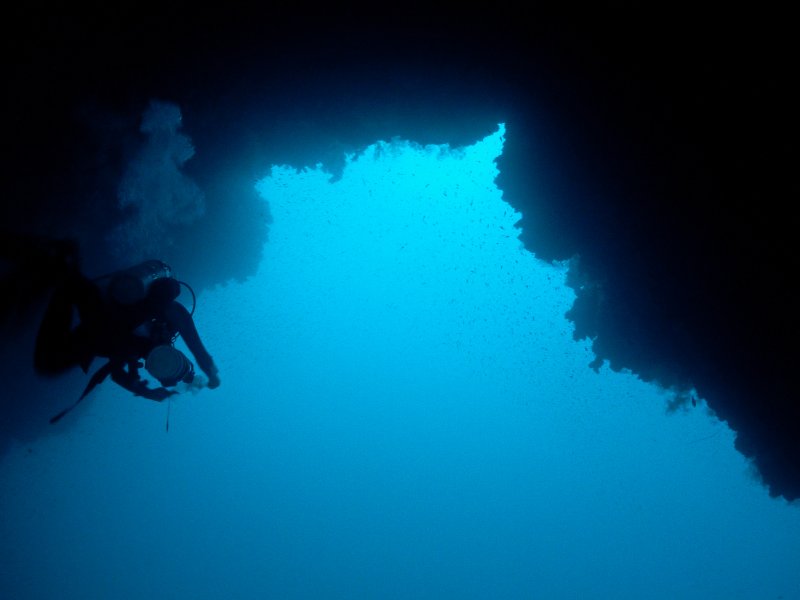
The Arch at the Dahab Blue Hole, seen from inside

Blue Hole and the Arch, Dahab

Foto: Tommi Salminen (Tsalminen (talk)) · CC BY-SA 3.0
Toegankelijk voor gekwalificeerde duikers, onder voorwaarden · zoals gepubliceerd 2026 Shore site in the Abu Galum Protected Area, dived through Dahab dive centres. A 2026 plan proposes regulating marine activities and capping visitors; no official fee or hours were found. Toegangsregels kunnen veranderen: bevestig dit bij de grondeigenaar of beherende instantie voordat je reist.
Gedocumenteerd Ook bekend als: Dahab Blue Hole, Blue Hole Dahab, The Arch, Blue Hole Arch, El Bells, The Bells
Diepte van de ingang
7 m (23 ft)
Veelbeduikte gebieden
Niet gepubliceerd
Maximale diepte hier
Niet gepubliceerd
Gepubliceerde categorie
Geen gepubliceerd

A shore-entry reef sinkhole north of Dahab. The upper bowl and reef are dived recreationally; the Arch, a tunnel whose top lies at about 52-55 m, is described by dive centres as a technical dive only.

Divers enter from the shore, often via the Bells chimney to the north, and cross into the Blue Hole over a saddle at about 6-7 m. A Dahab dive centre advises recreational divers to stay within 30-40 m, depending on their certification.

The Arch, about 26 m long, opens from the hole to the open sea with its top at roughly 52-55 m. A Dahab dive centre states it is out of bounds for recreational divers and should only be dived as a planned technical decompression dive. The site is in the Abu Galum Protected Area, and a 2026 government plan proposes tighter regulation of marine activities and visitor numbers.

De omgeving

Warm, clear sea water in a steep reef bowl over 100 m deep; the Arch is a short, deep overhead with open water and a deep drop-off beyond it.

Blue Hole and the Arch, Dahab Satelliet: NASA Blue Marble

Voor oriëntatie, niet voor navigatie. Holle stippen zijn bij benadering.

Bronnen: [1] Circle Divers ↗[2] Wikipedia ↗[3] Zawya ↗ · gecontroleerd 2026-10-14
Elk gegeven op deze pagina, met zijn bron (6)
GegevenStatusBron
The saddle connecting the hole to the outer reef is about 6-7 m deep. Gemeld [1] [2]
Recreational divers are advised to stay within 30-40 m depending on certification.Provider statement. Gemeld [1]
The top of the Arch is at roughly 52-55 m. Bronnen spreken elkaar tegen [1] [2]
The Arch should only be attempted by certified technical divers on a planned decompression dive with a qualified technical centre.Provider statement; no official rule text found. Gemeld [1]
The site lies in the Abu Galum Protected Area; a 2026 plan proposes regulating marine activities and capping visitor numbers. Gemeld [3]
Area-level coordinates for a widely published shore site. Gemeld [2] [1]

Geverifieerd: vermeld door een officiële of primaire bron die we hebben geraadpleegd. Gemeld: alleen afkomstig van een secundaire bron. Bronnen spreken elkaar tegen: de noot geeft beide versies. Mogelijk verouderd: de nieuwste bron die we hebben gevonden is oud.

In eigen woorden geschreven op basis van bovenstaande bronnen. Een correctie melden

Australië, Nieuw-Zeeland & Oost-Azië

Cairns & the Ribbon ReefsNingaloo ReefCoral Sea & Osprey ReefOkinawa & the Kerama IslandsPoor Knights IslandsTownsville & the YongalaGreen IslandIzu Peninsula

Caribisch gebied & westelijke Atlantische Oceaan

BonaireCozumelRiviera Maya & the CenotesBelize Barrier ReefGrand CaymanIsla Mujeres & CancúnRoatánTiger Beach & Grand Bahama

Europa, Atlantische Oceaan & Middellandse Zee

Malta & GozoSilfra & IcelandThe AzoresCanary IslandsLarnaca & the ZenobiaScapa FlowArctic NorwayMadeira

Indische Oceaan & Oost-Afrika

North & South Malé AtollsAri AtollBaa Atoll & Hanifaru BayAliwal Shoal & UmkomaasMafia IslandMauritiusSeychellesSodwana Bay

Pacifische eilanden & Micronesië

PalauChuuk (Truk) LagoonFakaravaKona, HawaiʻiRangiroaTaveuni & Rainbow ReefBeqa Lagoon & Pacific HarbourEspiritu Santo

Rode Zee & Midden-Oosten

Sharm El Sheikh & Ras MohammedBrothers, Daedalus & St John'sDahabHurghada & El GounaMarsa Alam & the Deep SouthAqabaDaymaniyat IslandsMusandam Peninsula

Zuidoost-Azië & Coral Triangle

Bali & Nusa PenidaKomodoRaja AmpatSipadan & MabulAnilaoCoronKoh TaoLembeh Strait

De Amerika's & Oost-Stille Oceaan

Galápagos IslandsCocos IslandFlorida KeysSea of Cortez & Cabo PulmoSocorro & the RevillagigedosBritish ColumbiaCalifornia Channel IslandsCosta Rica Pacific Coast