Temukan tempat menyelam, waktu terbaik untuk pergi, dan apa yang bisa Anda lihat.

Temukan tempat menyelam, waktu terbaik untuk pergi, dan apa yang bisa Anda lihat.
★
Menu
Destinasi Lokasi Selam Kehidupan Laut Bangkai kapal Berita
Rencanakan perjalanan Perencana trip Kapan waktu terbaik menyelam Kalkulator biaya Perbandingan Kalender kehidupan laut Suhu air Liveaboard Operator & resor Taman laut Ruang hiperbarik Peta dunia
Selam gua Semua cave diving Destinasi & Lokasi Selam Sistem Cave & Peta Pelatihan & Kualifikasi Pusat Selam & Pemandu Peralatan & Teknologi Riset Keselamatan & Insiden Sains, Sejarah & Konservasi Sumber Daya & Pembaruan
Wilayah Australia, Selandia Baru & Asia TimurKaribia & Atlantik BaratEropa, Atlantik & MediteraniaSamudra Hindia & Afrika TimurKepulauan Pasifik & MikronesiaLaut Merah & Timur TengahAsia Tenggara & Segitiga Terumbu KarangAmerika & Pasifik Timur Negara
Pelajari & Alat Semua panduan Sertifikasi Panduan perlengkapan Video Tanya Data Agen AI API
Tentang Tentang kami Metodologi Penafian Kontak
Tampilan kamu
★ Tersimpan

Destinasi, situs, dan spesies yang kamu tandai bintang, tersimpan di browser ini.

API GATEWAY

Akses JSON gratis hanya-baca ke data cache atlas.

Mode gelap

Tampilan Terpandu
Baru menyelam? Kedalaman, arus, level sertifikasi? Kami menjelaskan setiap istilah saat kamu menjelajah, dalam bahasa yang mudah dipahami. Data yang sama, dengan bantuan yang sudah terintegrasi.

Tampilan Ahli
Kamu sudah tahu perbedaan antara wall dan drift dive. Cukup datanya: bersih, cepat, dan ringkas. Ini adalah tampilan default.

Bahasa antarmuka
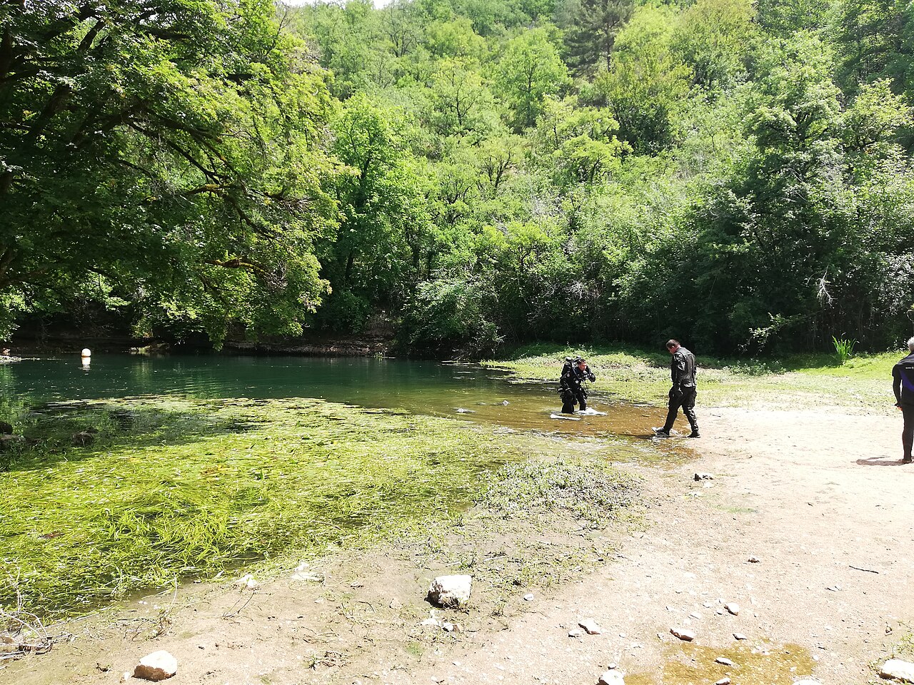
Divers leaving the Cabouy resurgence

Résurgence de Cabouy

Foto: GrandBout · CC BY-SA 4.0
Status akses belum terverifikasi · sesuai yang dipublikasikan 2015-05 No permit or rule is published in the sources consulted. The approach passes a house and the commune of Rocamadour's pumping station. Aturan akses bisa berubah: konfirmasikan dengan pemilik lahan atau otoritas pengelola sebelum Anda berangkat.
Terdokumentasi Juga dikenal sebagai: Gouffre de Cabouy, Cabouy, Source de Cabouy
Kedalaman pintu masuk
Tidak diterbitkan
Area yang umum diselami
15 m (49 ft)
Kedalaman maksimum di sini
31 m (102 ft)
Kategori yang diterbitkan
Tidak ada yang diterbitkan
Suhu air
14 °C

The main entrance to the flooded Ouysse river, a pool 20 to 25 m across in the Alzou valley about 3 km from Rocamadour, where the Ouysse begins its surface course.

Cabouy is reached by the small road that follows the Alzou valley from Rocamadour, over the col de Magès and past a house and the commune's pumping station. The resurgence pool is 20 to 25 m in diameter, with vegetation covering the bottom down to about 6 m.

A slope of debris leads to about 15 m at the gallery entrance and the conduit reaches 31 m at its porch. Divernet describes following a rope through near-zero visibility to the entrance, after which visibility improves and the passage opens into a large gallery. From the low point the floor rises to about 12 m some 275 m in and stays between 14 and 18 m to the 325 m mark, continuing towards Pou Meyssen.

Since 2012 a rope tied to a tree above the entrance links the surface to an anchor at -9 m, where the guideline laid in 2011-2014 starts; the line carries distance tags from Cabouy every 50 m.

Lingkungan

A large spring pool with weed in the shallows, a silty approach and a big river gallery beyond; seasonal floods.

Kondisi

Typical only. Divernet describes near-zero visibility on the approach to the entrance improving inside; seasonal floods damage the guideline.

Rentang tipikal dari sumber yang dipublikasikan, bukan kondisi saat ini.

Pintu masuk lain ke Réseau de l'Ouysse (Cabouy – Pou Meyssen)

Untuk orientasi, bukan navigasi. Titik kosong menunjukkan posisi perkiraan.

Sumber: [1] plongeesout.ffspeleo.fr ↗[2] FFESSM / Subaqua ↗[3] Divernet ↗[4] The Cave To Be ↗ · telah diperiksa 2026-10-14
Setiap fakta di halaman ini, beserta sumbernya (10)
FaktaStatusSumber
The resurgence basin is 20 to 25 m in diameter and vegetation covers the bottom to about 6 m. Terverifikasi [1]
The debris slope reaches about 15 m at the gallery entrance; beyond the low point the passage lies between about 12 and 18 m for the first few hundred metres. Terverifikasi [1]
The conduit reaches 31 m at its entrance porch, the low point near Cabouy.Subaqua gives about 30 m. Terverifikasi [1] [2]
A rope from a tree above the entrance runs to an anchor at -9 m where the new guideline starts, with distance tags every 50 m.Installed 2012-2014; condition today not verified. Terverifikasi [2]
Divernet gives about 14 °C as the average water temperature in Lot caves.Regional average. Dilaporkan [3]
A rope is followed through zero visibility to the entrance, after which visibility improves greatly. Dilaporkan [3]
The approach passes a house and the pumping station the commune of Rocamadour built for its water supply; no access rules are stated. Dilaporkan [1]
Published at N 44°47'26" E 1°35'03". Terverifikasi [1] [4]
The sources consulted publish no qualification, permit or registration requirement set by a land manager or access body for this site.Absence of a published rule, not confirmation that none exists. Dilaporkan [1]

Terverifikasi: dinyatakan oleh sumber resmi atau sumber primer yang kami buka langsung. Dilaporkan: hanya dari sumber sekunder. Sumber berbeda pendapat: catatan menyajikan kedua versi. Mungkin sudah kedaluwarsa: sumber terbaru yang kami temukan sudah lama.

Ditulis dengan kata-kata kami sendiri berdasarkan sumber di atas. Laporkan koreksi

Australia, Selandia Baru & Asia Timur

Cairns & the Ribbon ReefsNingaloo ReefCoral Sea & Osprey ReefOkinawa & the Kerama IslandsPoor Knights IslandsTownsville & the YongalaGreen IslandIzu Peninsula

Karibia & Atlantik Barat

BonaireCozumelRiviera Maya & the CenotesBelize Barrier ReefGrand CaymanIsla Mujeres & CancúnRoatánTiger Beach & Grand Bahama

Eropa, Atlantik & Mediterania

Malta & GozoSilfra & IcelandThe AzoresCanary IslandsLarnaca & the ZenobiaScapa FlowArctic NorwayMadeira

Samudra Hindia & Afrika Timur

North & South Malé AtollsAri AtollBaa Atoll & Hanifaru BayAliwal Shoal & UmkomaasMafia IslandMauritiusSeychellesSodwana Bay

Kepulauan Pasifik & Mikronesia

PalauChuuk (Truk) LagoonFakaravaKona, HawaiʻiRangiroaTaveuni & Rainbow ReefBeqa Lagoon & Pacific HarbourEspiritu Santo

Laut Merah & Timur Tengah

Sharm El Sheikh & Ras MohammedBrothers, Daedalus & St John'sDahabHurghada & El GounaMarsa Alam & the Deep SouthAqabaDaymaniyat IslandsMusandam Peninsula

Asia Tenggara & Segitiga Terumbu Karang

Bali & Nusa PenidaKomodoRaja AmpatSipadan & MabulAnilaoCoronKoh TaoLembeh Strait

Amerika & Pasifik Timur

Galápagos IslandsCocos IslandFlorida KeysSea of Cortez & Cabo PulmoSocorro & the RevillagigedosBritish ColumbiaCalifornia Channel IslandsCosta Rica Pacific Coast