Ontdek waar je kunt duiken, wanneer je moet gaan en wat je zou kunnen zien.

Ontdek waar je kunt duiken, wanneer je moet gaan en wat je zou kunnen zien.
★
Menu
Bestemmingen Duiklocaties Zeeleven Wrakken Nieuws
Plan een reis Reisplanner Wanneer duiken Kostencalculator Vergelijkingen Zeeleven-kalender Watertemperatuur Liveaboards Operators & resorts Mariene parken Hyperbare kamers Wereldkaart
Grotduiken Alle grotduiken Bestemmingen & duiklocaties Grottenstelsels en kaarten Training & Kwalificaties Duikcentra & gidsen Uitrusting & technologie Veiligheid & incidentonderzoek Wetenschap, geschiedenis & natuurbehoud Bronnen & updates
Regio's Australië, Nieuw-Zeeland & Oost-AziëCaribisch gebied & westelijke Atlantische OceaanEuropa, Atlantische Oceaan & Middellandse ZeeIndische Oceaan & Oost-AfrikaPacifische eilanden & MicronesiëRode Zee & Midden-OostenZuidoost-Azië & Coral TriangleDe Amerika's & Oost-Stille Oceaan Landen
Leren & Tools Alle gidsen Brevetten Uitrustingsgidsen Video's Vraag de data AI-agents API
Over Over ons Methodologie Disclaimer Contact
Jouw weergave
★ Opgeslagen

Je favoriete bestemmingen, duikplekken en soorten, opgeslagen in deze browser.

API GATEWAY

Gratis alleen-lezen JSON-toegang tot de gecachede data van de atlas.

Donkere modus

Begeleide weergave
Nieuw met duiken? Dieptes, stromingen, brevetniveaus? We leggen elke term uit terwijl je bladert, in gewone taal. Dezelfde gegevens, met ingebouwde uitleg.

Expertweergave
Je kent het verschil tussen een wall en een drift dive al. Alleen de data: overzichtelijk, snel en compact. Dit is de standaardweergave.

Interfacetaal
The Hranice Abyss

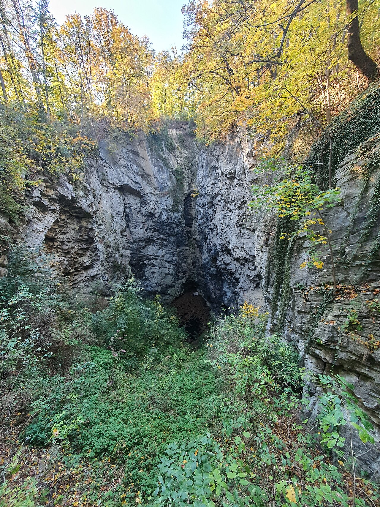
Hranice Abyss – shaft and lake

Verzakkingtot 450.6 mHranice AbyssCzechia
Foto: Qasinka · CC0
Beperkte toegang · zoals gepubliceerd 2026-10-14 Public access is to the viewing platform only. Research diving by ZO 7-02 Hranický kras under an exemption from the nature protection act; the reserve is managed by the Nature Conservation Agency's Olomouc office. Toegangsregels kunnen veranderen: bevestig dit bij de grondeigenaar of beherende instantie voordat je reist.
Goed gedocumenteerd Ook bekend als: Hranická propast, Hranice Abyss, Jezírko (Hranice Abyss lake)
Diepte van de ingang
69.5 m (228 ft)
Veelbeduikte gebieden
Niet gepubliceerd
Maximale diepte hier
450.6 m (1,478 ft)
Gepubliceerde categorie
Geen gepubliceerd

The single entrance to Hranice Abyss: a 69.5 m deep dry shaft ending at a small green lake that drops to more than 450 m. Viewable from a public platform; the water is a research-only dive site.

The rim of the abyss lies at about 315 m above sea level in the Hůrka u Hranic National Nature Reserve. The dry shaft descends 69.5 m to a small lake that appears to be the floor of the shaft but is in fact the surface of a flooded chasm more than 450 m deep.

Visitors can reach a viewing platform on foot from Teplice nad Bečvou railway station along a nature trail, or from the Hranice campsite on marked trails. The water itself is reached only by the research team of ZO 7-02 Hranický kras, which works under a legal exemption and maintains equipment such as a winch for its dives.

De omgeving

Lukewarm, CO2-saturated mineral water in a vertical chasm cut in limestone; a 2022 trap survey found no amphipods and researchers judged the deep water unsuitable for life.

Faciliteiten

Viewing platform over the shaft; marked trails from Teplice nad Bečvou railway station and the Hranice campsite.

Bronnen: [1] ZO ČSS 7-02 Hranický kras ↗[2] ZO ČSS 7-02 Hranický kras ↗[3] ZO ČSS 7-02 Hranický kras ↗ · gecontroleerd 2026-10-14
Elk gegeven op deze pagina, met zijn bron (6)
GegevenStatusBron
The dry entrance shaft is 69.5 m deep, 104 m long and 34 m wide. Geverifieerd [2] [3]
The flooded part was measured at 450.6 m deep in 2022 without reaching the bottom.Older figure of 404 m (2016) is still shown elsewhere on the site. Geverifieerd [2]
Research is carried out by ZO 7-02 Hranický kras under an exemption from Act No. 114/1992 Coll.; the reserve is managed by the Nature Conservation Agency of the Czech Republic, Olomouc office.No public diving rules were found. Geverifieerd [1] [2]
A viewing platform overlooks the shaft, reached on foot from Teplice nad Bečvou station or the Hranice campsite. Geverifieerd [1] [3]
The rim of the abyss is at 315 m above sea level. Geverifieerd [2]
Diving is done by the research group under an exemption from Act No. 114/1992 Coll. Geverifieerd [1]

Geverifieerd: vermeld door een officiële of primaire bron die we hebben geraadpleegd. Gemeld: alleen afkomstig van een secundaire bron. Bronnen spreken elkaar tegen: de noot geeft beide versies. Mogelijk verouderd: de nieuwste bron die we hebben gevonden is oud.

In eigen woorden geschreven op basis van bovenstaande bronnen. Een correctie melden

Australië, Nieuw-Zeeland & Oost-Azië

Cairns & the Ribbon ReefsNingaloo ReefCoral Sea & Osprey ReefOkinawa & the Kerama IslandsPoor Knights IslandsTownsville & the YongalaGreen IslandIzu Peninsula

Caribisch gebied & westelijke Atlantische Oceaan

BonaireCozumelRiviera Maya & the CenotesBelize Barrier ReefGrand CaymanIsla Mujeres & CancúnRoatánTiger Beach & Grand Bahama

Europa, Atlantische Oceaan & Middellandse Zee

Malta & GozoSilfra & IcelandThe AzoresCanary IslandsLarnaca & the ZenobiaScapa FlowArctic NorwayMadeira

Indische Oceaan & Oost-Afrika

North & South Malé AtollsAri AtollBaa Atoll & Hanifaru BayAliwal Shoal & UmkomaasMafia IslandMauritiusSeychellesSodwana Bay

Pacifische eilanden & Micronesië

PalauChuuk (Truk) LagoonFakaravaKona, HawaiʻiRangiroaTaveuni & Rainbow ReefBeqa Lagoon & Pacific HarbourEspiritu Santo

Rode Zee & Midden-Oosten

Sharm El Sheikh & Ras MohammedBrothers, Daedalus & St John'sDahabHurghada & El GounaMarsa Alam & the Deep SouthAqabaDaymaniyat IslandsMusandam Peninsula

Zuidoost-Azië & Coral Triangle

Bali & Nusa PenidaKomodoRaja AmpatSipadan & MabulAnilaoCoronKoh TaoLembeh Strait

De Amerika's & Oost-Stille Oceaan

Galápagos IslandsCocos IslandFlorida KeysSea of Cortez & Cabo PulmoSocorro & the RevillagigedosBritish ColumbiaCalifornia Channel IslandsCosta Rica Pacific Coast