اكتشف أين تغوص، ومتى تذهب، وما الذي يمكن أن تراه.

اكتشف أين تغوص، ومتى تذهب، وما الذي يمكن أن تراه.
★
القائمة
الوجهات مواقع الغوص الحياة البحرية حطام السفن الأخبار
خطّط لرحلة مخطّط الرحلات أفضل أوقات الغوص حاسبة التكاليف مقارنات تقويم الحياة البحرية درجة حرارة الماء الليفبوردات المشغّلون والمنتجعات المحميات البحرية غرف الضغط العالي خريطة العالم
الغوص في الكهوف جميع غطسات الكهوف الوجهات ومواقع الغوص أنظمة الكهوف والخرائط التدريب والمؤهلات مراكز الغوص والمرشدون المعدات والتكنولوجيا أبحاث السلامة والحوادث العلوم والتاريخ والحفاظ على البيئة الموارد والتحديثات
المناطق أستراليا، نيوزيلندا وشرق آسياالبحر الكاريبي وغرب المحيط الأطلسيأوروبا والأطلسي والمتوسطالمحيط الهندي وشرق أفريقياجزر المحيط الهادئ وميكرونيزياالبحر الأحمر والشرق الأوسطجنوب شرق آسيا ومثلث الشعاب المرجانيةالأمريكتان والمحيط الهادئ الشرقي الدول
التعلّم والأدوات جميع الأدلة الشهادات أدلة المعدات مقاطع فيديو استفسر عن البيانات وكلاء الذكاء الاصطناعي API
حول من نحن المنهجية إخلاء المسؤولية تواصل معنا
عرضك
★ محفوظ

وجهاتك وموقعك ومواقع الأنواع المحفوظة بالنجوم، مخزّنة في هذا المتصفح.

API GATEWAY

وصول JSON مجاني للقراءة فقط إلى البيانات المخزّنة في الأطلس.

الوضع الداكن

عرض المرشد
جديد على الغطس؟ الأعماق والتيارات ومستويات الشهادات؟ نشرح كل مصطلح أثناء تصفّحك بلغة واضحة. نفس البيانات، مع الشرح مدمجاً.

عرض الخبراء
أنت تعرف أصلًا الفرق بين الجدار وال drift dive. إليك البيانات فقط: واضحة وسريعة ومختصرة. هذا هو العرض الافتراضي.

لغة الواجهة
Dean's Blue Hole

Dean's Blue Hole

الفجوة الزرقاء202 m عميقThe Bahamas, Long Island
الصورة: Oceanwave77 · CC BY-SA 4.0
حالة الوصول غير موثّقة · كما هو منشور 2026-10-14 A beach-side blue hole reached on foot by a rocky path; the tourism ministry lists the Long Island Tourist Office as contact. No permit or diving rules are published. قواعد الوصول تتغير: تأكد مع مالك الأرض أو الجهة المشرفة قبل سفرك.
موثَّق يُعرف أيضًا باسم: Deans Blue Hole, Dean's Hole
الطول المُمسوح
غير منشور
العمق الموثق
202 m (663 ft)
المداخل المُدرجة
1
الرؤية
10–50 m

Not a linear cave; the published dimensions are the surface opening (about 45 x 55 m) and the chamber (at least 100 m across). The tourism ministry and the Grand Bahama Museum give 663 ft (about 202 m); Vertical Blue gives 203 m.

A coastal blue hole near Clarence Town on Long Island, about 200 m deep, that opens below a narrow neck into a cavern at least 100 m across. It is best known as the venue of the Vertical Blue freediving competition.

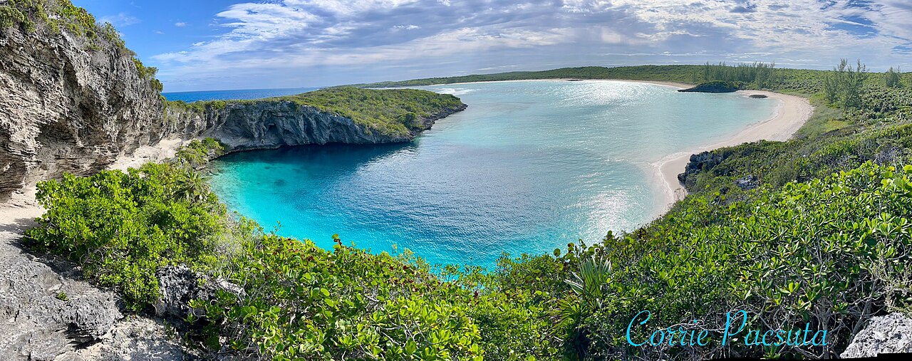
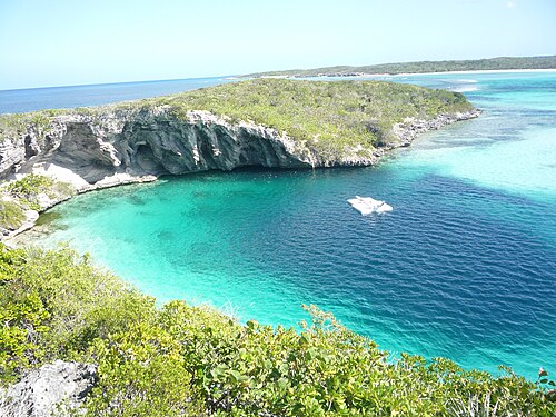
Dean's Blue Hole sits in a sheltered bay next to a beach on Long Island, ringed on three sides by rock walls. At the surface it measures roughly 45 by 55 m, narrows to a series of ledges at 10 to 15 m, and then opens into a huge chamber that the freediving organiser Vertical Blue describes as at least 100 m in diameter.

With a depth usually given as about 202-203 m, it is among the deepest known blue holes; the Grand Bahama Museum and Vertical Blue call it the second deepest blue hole in the world, while the Bahamas tourism ministry says third deepest. How it formed is still debated, since it is much deeper than most Caribbean blue holes.

The site is used mainly for freediving and snorkelling. It hosts the annual Vertical Blue freediving competition, and the water is sheltered from swell and current. No cave penetration route or land-manager diving rules are published.

الجيولوجيا

Vertical Blue notes that the origin of the hole is unresolved; one hypothesis is that a much deeper cave migrated upward as its ceiling collapsed over time.

الظروف

Vertical Blue describes no current or waves inside the hole and visibility of roughly 10 to 50 m. Tarpon, turtles and reef fish visit the entrance area.

نطاقات اعتيادية من مصادر منشورة، لا ظروف آنية.

المداخل ومواقع الغوص

One open entrance from a public beach and lagoon.
Dean's Blue HoleDean's Blue Hole صور الأقمار الاصطناعية: NASA Blue Marble

للتوجه العام، لا للملاحة. النقاط المفرغة تحديد تقريبي.

المصادر: [1] The Islands of The Bahamas (Bahamas Ministry of Tourism) ↗[2] Vertical Blue ↗[3] Grand Bahama Museum ↗[4] GeoNames ↗ · تم التحقق 2026-10-14
كل حقيقة في هذه الصفحة مع مصدرها (7)
حقيقةالحالةالمصدر
Dean's Blue Hole is about 663 ft (202 m) deep.Vertical Blue gives 203 m. Ranking conflicts: Vertical Blue and the Grand Bahama Museum say second deepest; the tourism ministry says third. تم الإبلاغ [1] [3] [2]
The hole measures about 45 x 55 m at the surface, narrows to about 25 x 35 m with ledges at 10-15 m, then opens into a cavern at least 100 m in diameter.Freediving organiser's description. تم الإبلاغ [2]
Visibility is about 10 to 50 m.Freediving organiser's figure; typical, not current. تم الإبلاغ [2]
The annual Vertical Blue freediving competition is held at the hole. موثق [1] [2]
Visitors reach the hole by a rocky path from the beach; contact is the Long Island Tourist Office.No permit or diving rules listed. موثق [1]
The formation of the hole is not fully understood; one hypothesis is upward migration of a deeper cave by roof collapse. تم الإبلاغ [2]
Area coordinates are those of Clarence Town in the GeoNames gazetteer; the Grand Bahama Museum places the hole in Clarence Town.Settlement-level; the hole lies close to the town. تم الإبلاغ [4] [3]

موثق: مُصرَّح به من مصدر رسمي أو أولي فتحناه. مُبلَّغ عنه: من مصدر ثانوي فقط. المصادر متضاربة: تتضمن الملاحظة النسختين. قد يكون قديماً: أحدث مصدر وجدناه قديم.

مكتوب بأسلوبنا الخاص من المصادر أعلاه. الإبلاغ عن تصحيح

أستراليا، نيوزيلندا وشرق آسيا

Cairns & the Ribbon ReefsNingaloo ReefCoral Sea & Osprey ReefOkinawa & the Kerama IslandsPoor Knights IslandsTownsville & the YongalaGreen IslandIzu Peninsula

البحر الكاريبي وغرب المحيط الأطلسي

BonaireCozumelRiviera Maya & the CenotesBelize Barrier ReefGrand CaymanIsla Mujeres & CancúnRoatánTiger Beach & Grand Bahama

أوروبا والأطلسي والمتوسط

Malta & GozoSilfra & IcelandThe AzoresCanary IslandsLarnaca & the ZenobiaScapa FlowArctic NorwayMadeira

المحيط الهندي وشرق أفريقيا

North & South Malé AtollsAri AtollBaa Atoll & Hanifaru BayAliwal Shoal & UmkomaasMafia IslandMauritiusSeychellesSodwana Bay

جزر المحيط الهادئ وميكرونيزيا

PalauChuuk (Truk) LagoonFakaravaKona, HawaiʻiRangiroaTaveuni & Rainbow ReefBeqa Lagoon & Pacific HarbourEspiritu Santo

البحر الأحمر والشرق الأوسط

Sharm El Sheikh & Ras MohammedBrothers, Daedalus & St John'sDahabHurghada & El GounaMarsa Alam & the Deep SouthAqabaDaymaniyat IslandsMusandam Peninsula

جنوب شرق آسيا ومثلث الشعاب المرجانية

Bali & Nusa PenidaKomodoRaja AmpatSipadan & MabulAnilaoCoronKoh TaoLembeh Strait

الأمريكتان والمحيط الهادئ الشرقي

Galápagos IslandsCocos IslandFlorida KeysSea of Cortez & Cabo PulmoSocorro & the RevillagigedosBritish ColumbiaCalifornia Channel IslandsCosta Rica Pacific Coast