Entdecken Sie, wo Sie tauchen können, wann die beste Zeit ist und was Sie sehen könnten.

Entdecken Sie, wo Sie tauchen können, wann die beste Zeit ist und was Sie sehen könnten.
★
Menü
Reiseziele Tauchplätze Meeresleben Wracks News
Eine Reise planen Tauchtrip-Planer Wann tauchen Kostenrechner Vergleiche Meereslebewesen-Kalender Wassertemperatur Liveaboards Tauchbetriebe & Resorts Meeresschutzgebiete Druckkammern Weltkarte
Höhlentauchen Gesamtes Höhlentauchen Reiseziele & Tauchplätze Höhlensysteme und Karten Ausbildung & Qualifikationen Tauchbasen & Guides Ausrüstung & Technik Sicherheit & Unfallforschung Wissenschaft, Geschichte & Naturschutz Ressourcen & Aktuelles
Regionen Australien, Neuseeland & OstasienKaribik & WestatlantikEuropa, Atlantik & MittelmeerIndischer Ozean & OstafrikaPazifikinseln & MikronesienRotes Meer & Naher OstenSüdostasien & Korallen-DreieckAmerika & Östlicher Pazifik Länder
Lernen & Tools Alle Guides Zertifizierungen Ausrüstungsratgeber Videos Daten abfragen KI-Agenten API
Über uns Über uns Methodik Haftungsausschluss Kontakt
Deine Ansicht
★ Gespeichert

Deine gespeicherten Reiseziele, Tauchplätze und Arten, in diesem Browser gespeichert.

API-GATEWAY

Kostenloser, schreibgeschützter JSON-Zugriff auf die gecachten Daten des Atlas.

Dunkelmodus

Geführte Ansicht
Neu beim Tauchen? Tiefen, Strömungen, Zertifizierungsstufen? Wir erklären jeden Begriff beim Stöbern, in klarer Sprache. Dieselben Daten, mit eingebautem Erklärmodus.

Expertenansicht
Du kennst den Unterschied zwischen einem Wall und einem Drift Dive. Nur die Daten – klar, schnell und kompakt. Das ist die Standardansicht.

Oberflächensprache
Dean's Blue Hole

Dean's Blue Hole

Blue Hole202 m tiefThe Bahamas, Long Island
Foto: Oceanwave77 · CC BY-SA 4.0
Zugangsstatus nicht verifiziert · wie veröffentlicht 2026-10-14 A beach-side blue hole reached on foot by a rocky path; the tourism ministry lists the Long Island Tourist Office as contact. No permit or diving rules are published. Zugangsregeln können sich ändern: Bitte vor der Reise beim Grundstückseigentümer oder der zuständigen Behörde nachfragen.
Dokumentiert Auch bekannt als: Deans Blue Hole, Dean's Hole
Kartierte Länge
Nicht veröffentlicht
Dokumentierte Tiefe
202 m (663 ft)
Aufgeführte Zugänge
1
Sichtweite
10–50 m

Not a linear cave; the published dimensions are the surface opening (about 45 x 55 m) and the chamber (at least 100 m across). The tourism ministry and the Grand Bahama Museum give 663 ft (about 202 m); Vertical Blue gives 203 m.

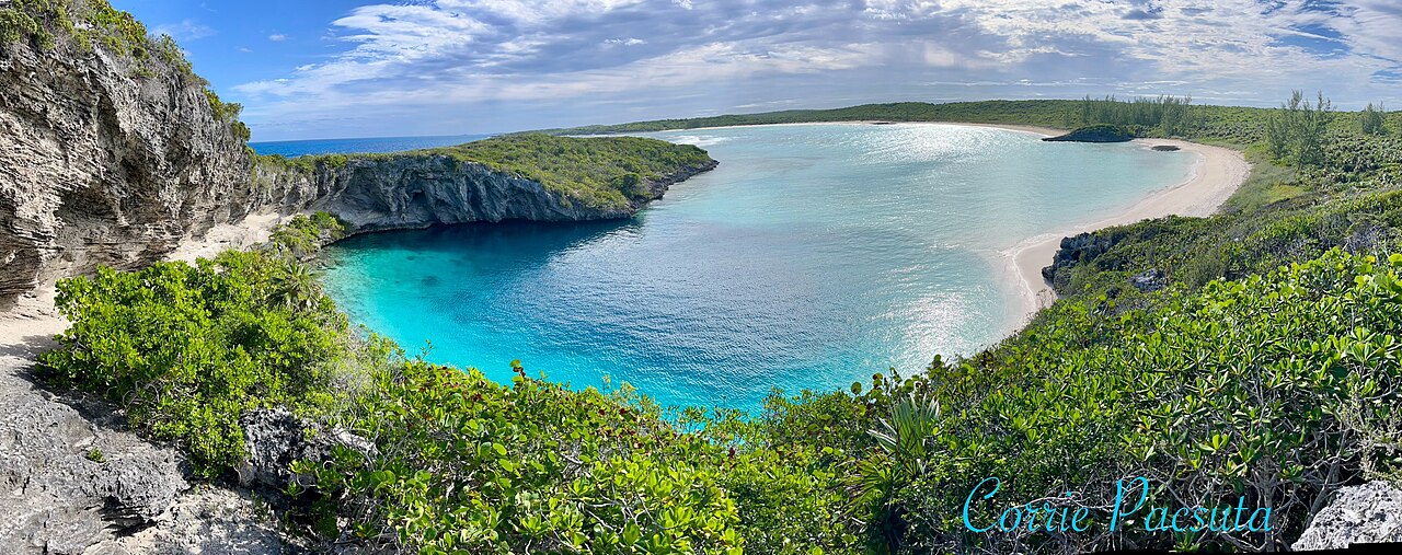
A coastal blue hole near Clarence Town on Long Island, about 200 m deep, that opens below a narrow neck into a cavern at least 100 m across. It is best known as the venue of the Vertical Blue freediving competition.

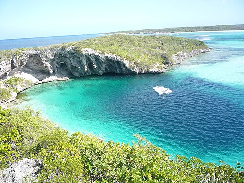
Dean's Blue Hole sits in a sheltered bay next to a beach on Long Island, ringed on three sides by rock walls. At the surface it measures roughly 45 by 55 m, narrows to a series of ledges at 10 to 15 m, and then opens into a huge chamber that the freediving organiser Vertical Blue describes as at least 100 m in diameter.

With a depth usually given as about 202-203 m, it is among the deepest known blue holes; the Grand Bahama Museum and Vertical Blue call it the second deepest blue hole in the world, while the Bahamas tourism ministry says third deepest. How it formed is still debated, since it is much deeper than most Caribbean blue holes.

The site is used mainly for freediving and snorkelling. It hosts the annual Vertical Blue freediving competition, and the water is sheltered from swell and current. No cave penetration route or land-manager diving rules are published.

Geologie

Vertical Blue notes that the origin of the hole is unresolved; one hypothesis is that a much deeper cave migrated upward as its ceiling collapsed over time.

Bedingungen

Vertical Blue describes no current or waves inside the hole and visibility of roughly 10 to 50 m. Tarpon, turtles and reef fish visit the entrance area.

Typische Wertebereiche aus veröffentlichten Quellen, keine aktuellen Bedingungen.

Zugänge und Tauchplätze

One open entrance from a public beach and lagoon.
Dean's Blue HoleDean's Blue Hole Satellitenbild: NASA Blue Marble

Zur Orientierung, nicht zur Navigation. Hohle Punkte sind ungefähre Angaben.

Quellen: [1] The Islands of The Bahamas (Bahamas Ministry of Tourism) ↗[2] Vertical Blue ↗[3] Grand Bahama Museum ↗[4] GeoNames ↗ · geprüft 2026-10-14
Alle Angaben auf dieser Seite mit Quellennachweis (7)
AngabeStatusQuelle
Dean's Blue Hole is about 663 ft (202 m) deep.Vertical Blue gives 203 m. Ranking conflicts: Vertical Blue and the Grand Bahama Museum say second deepest; the tourism ministry says third. Gemeldet [1] [3] [2]
The hole measures about 45 x 55 m at the surface, narrows to about 25 x 35 m with ledges at 10-15 m, then opens into a cavern at least 100 m in diameter.Freediving organiser's description. Gemeldet [2]
Visibility is about 10 to 50 m.Freediving organiser's figure; typical, not current. Gemeldet [2]
The annual Vertical Blue freediving competition is held at the hole. Verifiziert [1] [2]
Visitors reach the hole by a rocky path from the beach; contact is the Long Island Tourist Office.No permit or diving rules listed. Verifiziert [1]
The formation of the hole is not fully understood; one hypothesis is upward migration of a deeper cave by roof collapse. Gemeldet [2]
Area coordinates are those of Clarence Town in the GeoNames gazetteer; the Grand Bahama Museum places the hole in Clarence Town.Settlement-level; the hole lies close to the town. Gemeldet [4] [3]

Verifiziert: von einer offiziellen oder primären Quelle bestätigt, die wir geöffnet haben. Gemeldet: nur aus einer Sekundärquelle. Quellen widersprechen sich: Die Anmerkung enthält beide Versionen. Möglicherweise veraltet: Die neueste von uns gefundene Quelle ist alt.

In eigenen Worten aus den oben genannten Quellen verfasst. Korrektur melden

Australien, Neuseeland & Ostasien

Cairns & the Ribbon ReefsNingaloo ReefCoral Sea & Osprey ReefOkinawa & the Kerama IslandsPoor Knights IslandsTownsville & the YongalaGreen IslandIzu Peninsula

Karibik & Westatlantik

BonaireCozumelRiviera Maya & the CenotesBelize Barrier ReefGrand CaymanIsla Mujeres & CancúnRoatánTiger Beach & Grand Bahama

Europa, Atlantik & Mittelmeer

Malta & GozoSilfra & IcelandThe AzoresCanary IslandsLarnaca & the ZenobiaScapa FlowArctic NorwayMadeira

Indischer Ozean & Ostafrika

North & South Malé AtollsAri AtollBaa Atoll & Hanifaru BayAliwal Shoal & UmkomaasMafia IslandMauritiusSeychellesSodwana Bay

Pazifikinseln & Mikronesien

PalauChuuk (Truk) LagoonFakaravaKona, HawaiʻiRangiroaTaveuni & Rainbow ReefBeqa Lagoon & Pacific HarbourEspiritu Santo

Rotes Meer & Naher Osten

Sharm El Sheikh & Ras MohammedBrothers, Daedalus & St John'sDahabHurghada & El GounaMarsa Alam & the Deep SouthAqabaDaymaniyat IslandsMusandam Peninsula

Südostasien & Korallen-Dreieck

Bali & Nusa PenidaKomodoRaja AmpatSipadan & MabulAnilaoCoronKoh TaoLembeh Strait

Amerika & Östlicher Pazifik

Galápagos IslandsCocos IslandFlorida KeysSea of Cortez & Cabo PulmoSocorro & the RevillagigedosBritish ColumbiaCalifornia Channel IslandsCosta Rica Pacific Coast