Découvrez où plonger, quand partir et ce que vous pourriez voir.

Découvrez où plonger, quand partir et ce que vous pourriez voir.
★
Menu
Destinations Sites de plongée Vie marine Épaves Actualités
Planifier un voyage Planificateur de séjour Quand plonger Calculateur de coût Comparaisons Calendrier de la faune marine Température de l'eau Liveaboards Opérateurs & resorts Parcs marins Caissons hyperbares Carte du monde
Plongée souterraine Toute la plongée souterraine Destinations et sites de plongée Systèmes de grottes et cartes Formation et qualifications Centres de plongée et guides Équipement et technologie Sécurité et recherche sur les incidents Sciences, histoire et conservation Ressources et mises à jour
Régions Australie, Nouvelle-Zélande & Asie de l'EstCaraïbes & Atlantique occidentalEurope, Atlantique & MéditerranéeOcéan Indien & Afrique de l'EstÎles du Pacifique & MicronésieMer Rouge & Moyen-OrientAsie du Sud-Est et Triangle de CorailLes Amériques et Pacifique Est Pays
Apprendre & Outils Tous les guides Certifications Guides d'équipement Vidéos Interroger les données Agents IA API
À propos À propos de nous Méthodologie Avertissement Contact
Votre vue
★ Enregistré

Vos destinations, sites et espèces favoris, enregistrés dans ce navigateur.

API GATEWAY

Accès JSON gratuit en lecture seule aux données en cache de l'atlas.

Mode sombre

Vue Guidée
Nouveau en plongée ? Profondeurs, courants, niveaux de certification ? Nous expliquons chaque terme au fil de votre navigation, en langage clair. Les mêmes données, avec l'aide intégrée.

Vue Expert
Vous connaissez déjà la différence entre un tombant et un drift dive. Juste les données : claires, rapides et compactes. C'est la vue par défaut.

Langue de l'interface
Dean's Blue Hole

Dean's Blue Hole

Trou bleu202 m profondThe Bahamas, Long Island
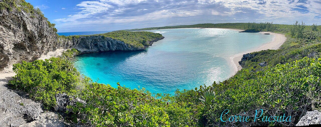
Photo: Oceanwave77 · CC BY-SA 4.0
Statut d'accès non vérifié · tel que publié 2026-10-14 A beach-side blue hole reached on foot by a rocky path; the tourism ministry lists the Long Island Tourist Office as contact. No permit or diving rules are published. Les règles d'accès changent : confirmez auprès du propriétaire ou de l'autorité gestionnaire avant de partir.
Documenté Aussi connu sous le nom de: Deans Blue Hole, Dean's Hole
Longueur explorée
Non publié
Profondeur documentée
202 m (663 ft)
Entrées répertoriées
1
Visibilité
10–50 m

Not a linear cave; the published dimensions are the surface opening (about 45 x 55 m) and the chamber (at least 100 m across). The tourism ministry and the Grand Bahama Museum give 663 ft (about 202 m); Vertical Blue gives 203 m.

A coastal blue hole near Clarence Town on Long Island, about 200 m deep, that opens below a narrow neck into a cavern at least 100 m across. It is best known as the venue of the Vertical Blue freediving competition.

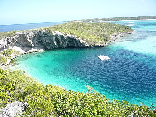
Dean's Blue Hole sits in a sheltered bay next to a beach on Long Island, ringed on three sides by rock walls. At the surface it measures roughly 45 by 55 m, narrows to a series of ledges at 10 to 15 m, and then opens into a huge chamber that the freediving organiser Vertical Blue describes as at least 100 m in diameter.

With a depth usually given as about 202-203 m, it is among the deepest known blue holes; the Grand Bahama Museum and Vertical Blue call it the second deepest blue hole in the world, while the Bahamas tourism ministry says third deepest. How it formed is still debated, since it is much deeper than most Caribbean blue holes.

The site is used mainly for freediving and snorkelling. It hosts the annual Vertical Blue freediving competition, and the water is sheltered from swell and current. No cave penetration route or land-manager diving rules are published.

Géologie

Vertical Blue notes that the origin of the hole is unresolved; one hypothesis is that a much deeper cave migrated upward as its ceiling collapsed over time.

Conditions

Vertical Blue describes no current or waves inside the hole and visibility of roughly 10 to 50 m. Tarpon, turtles and reef fish visit the entrance area.

Fourchettes indicatives issues de sources publiées, pas les conditions actuelles.

Entrées et sites de plongée

One open entrance from a public beach and lagoon.
Dean's Blue HoleDean's Blue Hole Satellite : NASA Blue Marble

Pour s'orienter, pas pour naviguer. Les points creux sont approximatifs.

Sources: [1] The Islands of The Bahamas (Bahamas Ministry of Tourism) ↗[2] Vertical Blue ↗[3] Grand Bahama Museum ↗[4] GeoNames ↗ · vérifié 2026-10-14
Chaque information de cette page, avec sa source (7)
InformationStatutSource
Dean's Blue Hole is about 663 ft (202 m) deep.Vertical Blue gives 203 m. Ranking conflicts: Vertical Blue and the Grand Bahama Museum say second deepest; the tourism ministry says third. Signalé [1] [3] [2]
The hole measures about 45 x 55 m at the surface, narrows to about 25 x 35 m with ledges at 10-15 m, then opens into a cavern at least 100 m in diameter.Freediving organiser's description. Signalé [2]
Visibility is about 10 to 50 m.Freediving organiser's figure; typical, not current. Signalé [2]
The annual Vertical Blue freediving competition is held at the hole. Vérifié [1] [2]
Visitors reach the hole by a rocky path from the beach; contact is the Long Island Tourist Office.No permit or diving rules listed. Vérifié [1]
The formation of the hole is not fully understood; one hypothesis is upward migration of a deeper cave by roof collapse. Signalé [2]
Area coordinates are those of Clarence Town in the GeoNames gazetteer; the Grand Bahama Museum places the hole in Clarence Town.Settlement-level; the hole lies close to the town. Signalé [4] [3]

Vérifié : indiqué par une source officielle ou primaire que nous avons consultée. Signalé : issu d'une source secondaire uniquement. Sources contradictoires : la note présente les deux versions. Peut être obsolète : la source la plus récente que nous avons trouvée est ancienne.

Rédigé dans nos propres mots à partir des sources ci-dessus. Signaler une correction

Australie, Nouvelle-Zélande & Asie de l'Est

Cairns & the Ribbon ReefsNingaloo ReefCoral Sea & Osprey ReefOkinawa & the Kerama IslandsPoor Knights IslandsTownsville & the YongalaGreen IslandIzu Peninsula

Caraïbes & Atlantique occidental

BonaireCozumelRiviera Maya & the CenotesBelize Barrier ReefGrand CaymanIsla Mujeres & CancúnRoatánTiger Beach & Grand Bahama

Europe, Atlantique & Méditerranée

Malta & GozoSilfra & IcelandThe AzoresCanary IslandsLarnaca & the ZenobiaScapa FlowArctic NorwayMadeira

Océan Indien & Afrique de l'Est

North & South Malé AtollsAri AtollBaa Atoll & Hanifaru BayAliwal Shoal & UmkomaasMafia IslandMauritiusSeychellesSodwana Bay

Îles du Pacifique & Micronésie

PalauChuuk (Truk) LagoonFakaravaKona, HawaiʻiRangiroaTaveuni & Rainbow ReefBeqa Lagoon & Pacific HarbourEspiritu Santo

Mer Rouge & Moyen-Orient

Sharm El Sheikh & Ras MohammedBrothers, Daedalus & St John'sDahabHurghada & El GounaMarsa Alam & the Deep SouthAqabaDaymaniyat IslandsMusandam Peninsula

Asie du Sud-Est et Triangle de Corail

Bali & Nusa PenidaKomodoRaja AmpatSipadan & MabulAnilaoCoronKoh TaoLembeh Strait

Les Amériques et Pacifique Est

Galápagos IslandsCocos IslandFlorida KeysSea of Cortez & Cabo PulmoSocorro & the RevillagigedosBritish ColumbiaCalifornia Channel IslandsCosta Rica Pacific Coast