Scopri dove immergerti, quando andare e cosa potresti vedere.

Scopri dove immergerti, quando andare e cosa potresti vedere.
★
Menu
Destinazioni Siti di immersione Vita marina Relitti Notizie
Pianifica un viaggio Pianificatore di viaggi Quando immergersi Calcolatore dei costi Confronti Calendario della fauna marina Temperatura dell'acqua Liveaboard Operatori & resort Parchi marini Camere iperbariche Mappa del mondo
Immersioni in grotta Tutta la speleologia subacquea Destinazioni e siti di immersione Sistemi di grotte e mappe Formazione e qualifiche Diving center e guide Attrezzatura e tecnologia Sicurezza e ricerca sugli incidenti Scienza, storia e conservazione Risorse e aggiornamenti
Regioni Australia, Nuova Zelanda e Asia OrientaleCaraibi e Atlantico occidentaleEuropa, Atlantico e MediterraneoOceano Indiano e Africa OrientaleIsole del Pacifico & MicronesiaMar Rosso & Medio OrienteAsia meridionale e Triangolo dei CoralliLe Americhe e il Pacifico orientale Paesi
Impara e strumenti Tutte le guide Brevetti Guide all'attrezzatura Video Interroga i dati AI Agent API
Informazioni Chi siamo Metodologia Disclaimer Contatti
La tua vista
★ Salvato

Le tue destinazioni, siti e specie preferiti, salvati in questo browser.

API GATEWAY

Accesso JSON gratuito in sola lettura ai dati in cache dell'atlante.

Modalità scura

Visualizzazione Guidata
Sei alle prime armi con le immersioni? Profondità, correnti, livelli di certificazione? Spieghiamo ogni termine mentre navighi, in modo semplice e chiaro. Gli stessi dati, con tutto il supporto integrato.

Visualizzazione Esperta
Conosci già la differenza tra una parete e una drift dive. Solo i dati: chiari, rapidi e sintetici. Questa è la visualizzazione predefinita.

Lingua dell'interfaccia
Dean's Blue Hole

Dean's Blue Hole

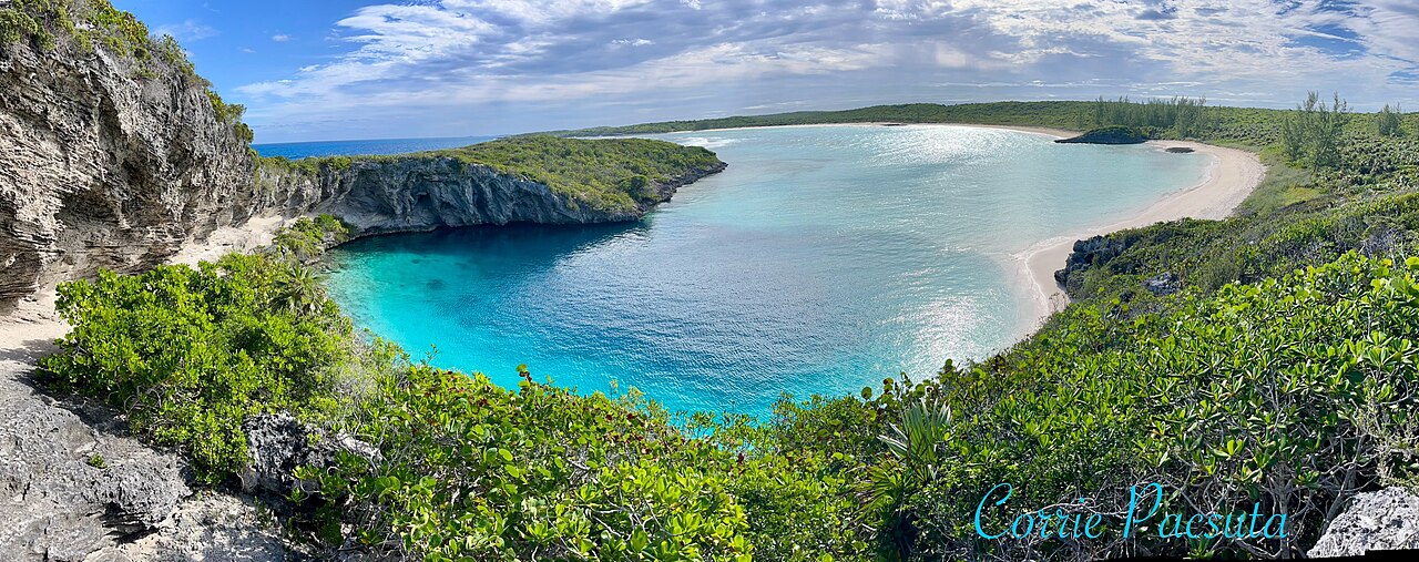
Blue hole202 m profondoThe Bahamas, Long Island
Foto: Oceanwave77 · CC BY-SA 4.0
Stato dell'accesso non verificato · come pubblicato 2026-10-14 A beach-side blue hole reached on foot by a rocky path; the tourism ministry lists the Long Island Tourist Office as contact. No permit or diving rules are published. Le regole di accesso cambiano: conferma con il proprietario del terreno o l'autorità di gestione prima di partire.
Documentato Conosciuto anche come: Deans Blue Hole, Dean's Hole
Sviluppo rilevato
Non pubblicato
Profondità documentata
202 m (663 ft)
Accessi elencati
1
Visibilità
10–50 m

Not a linear cave; the published dimensions are the surface opening (about 45 x 55 m) and the chamber (at least 100 m across). The tourism ministry and the Grand Bahama Museum give 663 ft (about 202 m); Vertical Blue gives 203 m.

A coastal blue hole near Clarence Town on Long Island, about 200 m deep, that opens below a narrow neck into a cavern at least 100 m across. It is best known as the venue of the Vertical Blue freediving competition.

Dean's Blue Hole sits in a sheltered bay next to a beach on Long Island, ringed on three sides by rock walls. At the surface it measures roughly 45 by 55 m, narrows to a series of ledges at 10 to 15 m, and then opens into a huge chamber that the freediving organiser Vertical Blue describes as at least 100 m in diameter.

With a depth usually given as about 202-203 m, it is among the deepest known blue holes; the Grand Bahama Museum and Vertical Blue call it the second deepest blue hole in the world, while the Bahamas tourism ministry says third deepest. How it formed is still debated, since it is much deeper than most Caribbean blue holes.

The site is used mainly for freediving and snorkelling. It hosts the annual Vertical Blue freediving competition, and the water is sheltered from swell and current. No cave penetration route or land-manager diving rules are published.

Geologia

Vertical Blue notes that the origin of the hole is unresolved; one hypothesis is that a much deeper cave migrated upward as its ceiling collapsed over time.

Condizioni

Vertical Blue describes no current or waves inside the hole and visibility of roughly 10 to 50 m. Tarpon, turtles and reef fish visit the entrance area.

Intervalli tipici da fonti pubblicate, non condizioni attuali.

Accessi e siti di immersione

One open entrance from a public beach and lagoon.
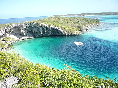
Dean's Blue HoleDean's Blue Hole Satellite: NASA Blue Marble

Per orientamento, non per navigazione. I punti vuoti sono approssimativi.

Fonti: [1] The Islands of The Bahamas (Bahamas Ministry of Tourism) ↗[2] Vertical Blue ↗[3] Grand Bahama Museum ↗[4] GeoNames ↗ · verificato 2026-10-14
Ogni informazione in questa pagina, con la relativa fonte (7)
InformazioneStatoFonte
Dean's Blue Hole is about 663 ft (202 m) deep.Vertical Blue gives 203 m. Ranking conflicts: Vertical Blue and the Grand Bahama Museum say second deepest; the tourism ministry says third. Segnalato [1] [3] [2]
The hole measures about 45 x 55 m at the surface, narrows to about 25 x 35 m with ledges at 10-15 m, then opens into a cavern at least 100 m in diameter.Freediving organiser's description. Segnalato [2]
Visibility is about 10 to 50 m.Freediving organiser's figure; typical, not current. Segnalato [2]
The annual Vertical Blue freediving competition is held at the hole. Verificato [1] [2]
Visitors reach the hole by a rocky path from the beach; contact is the Long Island Tourist Office.No permit or diving rules listed. Verificato [1]
The formation of the hole is not fully understood; one hypothesis is upward migration of a deeper cave by roof collapse. Segnalato [2]
Area coordinates are those of Clarence Town in the GeoNames gazetteer; the Grand Bahama Museum places the hole in Clarence Town.Settlement-level; the hole lies close to the town. Segnalato [4] [3]

Verificato: dichiarato da una fonte ufficiale o primaria che abbiamo consultato. Segnalato: da una fonte secondaria soltanto. Le fonti sono in contrasto: la nota riporta entrambe le versioni. Potrebbe essere non aggiornato: la fonte più recente che abbiamo trovato è datata.

Scritto con parole nostre dalle fonti indicate sopra. Segnala una correzione

Australia, Nuova Zelanda e Asia Orientale

Cairns & the Ribbon ReefsNingaloo ReefCoral Sea & Osprey ReefOkinawa & the Kerama IslandsPoor Knights IslandsTownsville & the YongalaGreen IslandIzu Peninsula

Caraibi e Atlantico occidentale

BonaireCozumelRiviera Maya & the CenotesBelize Barrier ReefGrand CaymanIsla Mujeres & CancúnRoatánTiger Beach & Grand Bahama

Europa, Atlantico e Mediterraneo

Malta & GozoSilfra & IcelandThe AzoresCanary IslandsLarnaca & the ZenobiaScapa FlowArctic NorwayMadeira

Oceano Indiano e Africa Orientale

North & South Malé AtollsAri AtollBaa Atoll & Hanifaru BayAliwal Shoal & UmkomaasMafia IslandMauritiusSeychellesSodwana Bay

Isole del Pacifico & Micronesia

PalauChuuk (Truk) LagoonFakaravaKona, HawaiʻiRangiroaTaveuni & Rainbow ReefBeqa Lagoon & Pacific HarbourEspiritu Santo

Mar Rosso & Medio Oriente

Sharm El Sheikh & Ras MohammedBrothers, Daedalus & St John'sDahabHurghada & El GounaMarsa Alam & the Deep SouthAqabaDaymaniyat IslandsMusandam Peninsula

Asia meridionale e Triangolo dei Coralli

Bali & Nusa PenidaKomodoRaja AmpatSipadan & MabulAnilaoCoronKoh TaoLembeh Strait

Le Americhe e il Pacifico orientale

Galápagos IslandsCocos IslandFlorida KeysSea of Cortez & Cabo PulmoSocorro & the RevillagigedosBritish ColumbiaCalifornia Channel IslandsCosta Rica Pacific Coast