Ontdek waar je kunt duiken, wanneer je moet gaan en wat je zou kunnen zien.

Ontdek waar je kunt duiken, wanneer je moet gaan en wat je zou kunnen zien.
★
Menu
Bestemmingen Duiklocaties Zeeleven Wrakken Nieuws
Plan een reis Reisplanner Wanneer duiken Kostencalculator Vergelijkingen Zeeleven-kalender Watertemperatuur Liveaboards Operators & resorts Mariene parken Hyperbare kamers Wereldkaart
Grotduiken Alle grotduiken Bestemmingen & duiklocaties Grottenstelsels en kaarten Training & Kwalificaties Duikcentra & gidsen Uitrusting & technologie Veiligheid & incidentonderzoek Wetenschap, geschiedenis & natuurbehoud Bronnen & updates
Regio's Australië, Nieuw-Zeeland & Oost-AziëCaribisch gebied & westelijke Atlantische OceaanEuropa, Atlantische Oceaan & Middellandse ZeeIndische Oceaan & Oost-AfrikaPacifische eilanden & MicronesiëRode Zee & Midden-OostenZuidoost-Azië & Coral TriangleDe Amerika's & Oost-Stille Oceaan Landen
Leren & Tools Alle gidsen Brevetten Uitrustingsgidsen Video's Vraag de data AI-agents API
Over Over ons Methodologie Disclaimer Contact
Jouw weergave
★ Opgeslagen

Je favoriete bestemmingen, duikplekken en soorten, opgeslagen in deze browser.

API GATEWAY

Gratis alleen-lezen JSON-toegang tot de gecachede data van de atlas.

Donkere modus

Begeleide weergave
Nieuw met duiken? Dieptes, stromingen, brevetniveaus? We leggen elke term uit terwijl je bladert, in gewone taal. Dezelfde gegevens, met ingebouwde uitleg.

Expertweergave
Je kent het verschil tussen een wall en een drift dive al. Alleen de data: overzichtelijk, snel en compact. Dit is de standaardweergave.

Interfacetaal
Dean's Blue Hole

Dean's Blue Hole

Blue hole202 m diepThe Bahamas, Long Island
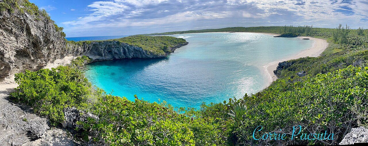
Foto: Oceanwave77 · CC BY-SA 4.0
Toegangsstatus niet geverifieerd · zoals gepubliceerd 2026-10-14 A beach-side blue hole reached on foot by a rocky path; the tourism ministry lists the Long Island Tourist Office as contact. No permit or diving rules are published. Toegangsregels kunnen veranderen: bevestig dit bij de grondeigenaar of beherende instantie voordat je reist.
Gedocumenteerd Ook bekend als: Deans Blue Hole, Dean's Hole
Gemeten lengte
Niet gepubliceerd
Gedocumenteerde diepte
202 m (663 ft)
Vermelde ingangen
1
Zicht
10–50 m

Not a linear cave; the published dimensions are the surface opening (about 45 x 55 m) and the chamber (at least 100 m across). The tourism ministry and the Grand Bahama Museum give 663 ft (about 202 m); Vertical Blue gives 203 m.

A coastal blue hole near Clarence Town on Long Island, about 200 m deep, that opens below a narrow neck into a cavern at least 100 m across. It is best known as the venue of the Vertical Blue freediving competition.

Dean's Blue Hole sits in a sheltered bay next to a beach on Long Island, ringed on three sides by rock walls. At the surface it measures roughly 45 by 55 m, narrows to a series of ledges at 10 to 15 m, and then opens into a huge chamber that the freediving organiser Vertical Blue describes as at least 100 m in diameter.

With a depth usually given as about 202-203 m, it is among the deepest known blue holes; the Grand Bahama Museum and Vertical Blue call it the second deepest blue hole in the world, while the Bahamas tourism ministry says third deepest. How it formed is still debated, since it is much deeper than most Caribbean blue holes.

The site is used mainly for freediving and snorkelling. It hosts the annual Vertical Blue freediving competition, and the water is sheltered from swell and current. No cave penetration route or land-manager diving rules are published.

Geologie

Vertical Blue notes that the origin of the hole is unresolved; one hypothesis is that a much deeper cave migrated upward as its ceiling collapsed over time.

Omstandigheden

Vertical Blue describes no current or waves inside the hole and visibility of roughly 10 to 50 m. Tarpon, turtles and reef fish visit the entrance area.

Gebruikelijke ranges uit gepubliceerde bronnen, geen actuele omstandigheden.

Ingangen en duiklocaties

One open entrance from a public beach and lagoon.
Dean's Blue HoleDean's Blue Hole Satelliet: NASA Blue Marble

Voor oriëntatie, niet voor navigatie. Holle stippen zijn bij benadering.

Bronnen: [1] The Islands of The Bahamas (Bahamas Ministry of Tourism) ↗[2] Vertical Blue ↗[3] Grand Bahama Museum ↗[4] GeoNames ↗ · gecontroleerd 2026-10-14
Elk gegeven op deze pagina, met zijn bron (7)
GegevenStatusBron
Dean's Blue Hole is about 663 ft (202 m) deep.Vertical Blue gives 203 m. Ranking conflicts: Vertical Blue and the Grand Bahama Museum say second deepest; the tourism ministry says third. Gemeld [1] [3] [2]
The hole measures about 45 x 55 m at the surface, narrows to about 25 x 35 m with ledges at 10-15 m, then opens into a cavern at least 100 m in diameter.Freediving organiser's description. Gemeld [2]
Visibility is about 10 to 50 m.Freediving organiser's figure; typical, not current. Gemeld [2]
The annual Vertical Blue freediving competition is held at the hole. Geverifieerd [1] [2]
Visitors reach the hole by a rocky path from the beach; contact is the Long Island Tourist Office.No permit or diving rules listed. Geverifieerd [1]
The formation of the hole is not fully understood; one hypothesis is upward migration of a deeper cave by roof collapse. Gemeld [2]
Area coordinates are those of Clarence Town in the GeoNames gazetteer; the Grand Bahama Museum places the hole in Clarence Town.Settlement-level; the hole lies close to the town. Gemeld [4] [3]

Geverifieerd: vermeld door een officiële of primaire bron die we hebben geraadpleegd. Gemeld: alleen afkomstig van een secundaire bron. Bronnen spreken elkaar tegen: de noot geeft beide versies. Mogelijk verouderd: de nieuwste bron die we hebben gevonden is oud.

In eigen woorden geschreven op basis van bovenstaande bronnen. Een correctie melden

Australië, Nieuw-Zeeland & Oost-Azië

Cairns & the Ribbon ReefsNingaloo ReefCoral Sea & Osprey ReefOkinawa & the Kerama IslandsPoor Knights IslandsTownsville & the YongalaGreen IslandIzu Peninsula

Caribisch gebied & westelijke Atlantische Oceaan

BonaireCozumelRiviera Maya & the CenotesBelize Barrier ReefGrand CaymanIsla Mujeres & CancúnRoatánTiger Beach & Grand Bahama

Europa, Atlantische Oceaan & Middellandse Zee

Malta & GozoSilfra & IcelandThe AzoresCanary IslandsLarnaca & the ZenobiaScapa FlowArctic NorwayMadeira

Indische Oceaan & Oost-Afrika

North & South Malé AtollsAri AtollBaa Atoll & Hanifaru BayAliwal Shoal & UmkomaasMafia IslandMauritiusSeychellesSodwana Bay

Pacifische eilanden & Micronesië

PalauChuuk (Truk) LagoonFakaravaKona, HawaiʻiRangiroaTaveuni & Rainbow ReefBeqa Lagoon & Pacific HarbourEspiritu Santo

Rode Zee & Midden-Oosten

Sharm El Sheikh & Ras MohammedBrothers, Daedalus & St John'sDahabHurghada & El GounaMarsa Alam & the Deep SouthAqabaDaymaniyat IslandsMusandam Peninsula

Zuidoost-Azië & Coral Triangle

Bali & Nusa PenidaKomodoRaja AmpatSipadan & MabulAnilaoCoronKoh TaoLembeh Strait

De Amerika's & Oost-Stille Oceaan

Galápagos IslandsCocos IslandFlorida KeysSea of Cortez & Cabo PulmoSocorro & the RevillagigedosBritish ColumbiaCalifornia Channel IslandsCosta Rica Pacific Coast