Descubra onde mergulhar, quando ir e o que poderá ver.

Descubra onde mergulhar, quando ir e o que poderá ver.
★
Menu
Destinos Pontos de Mergulho Vida Marinha Naufrágios Notícias
Planejar uma viagem Planejador de viagem Quando mergulhar Calculadora de custos Comparações Calendário de vida marinha Temperatura da água Liveaboards Operadores & resorts Parques marinhos Câmaras hiperbáricas Mapa mundial
Mergulho em cavernas Todo o mergulho em cavernas Destinos e Pontos de Mergulho Sistemas de Cavernas e Mapas Formação e qualificações Centros de Mergulho e Guias Equipamento e Tecnologia Pesquisa de segurança e incidentes Ciência, história e conservação Recursos e atualizações
Regiões Austrália, Nova Zelândia e Ásia OrientalCaribe e Atlântico OcidentalEuropa, Atlântico & MediterrâneoOceano Índico e África OrientalIlhas do Pacífico & MicronésiaMar Vermelho & Médio OrienteSudeste Asiático e Triângulo de CoralAs Américas e o Pacífico Oriental Países
Aprender e Ferramentas Todos os guias Certificações Guias de equipamento Vídeos Consulte os Dados Agentes de IA API
Sobre Sobre nós Metodologia Aviso legal Contato
A sua vista
★ Guardado

Os seus destinos, pontos de mergulho e espécies favoritos, guardados neste browser.

API GATEWAY

Acesso JSON gratuito e só de leitura aos dados em cache do atlas.

Modo escuro

Vista Guiada
Novo no mergulho? Profundidades, correntes, níveis de certificação? Explicamos cada termo enquanto navegas, em linguagem simples. Os mesmos dados, com a ajuda incluída.

Vista de Especialista
Já sabe a diferença entre uma parede e um drift dive. Apenas os dados: limpos, rápidos e compactos. Esta é a vista predefinida.

Idioma da interface
Dean's Blue Hole

Dean's Blue Hole

Blue hole202 m profundoThe Bahamas, Long Island
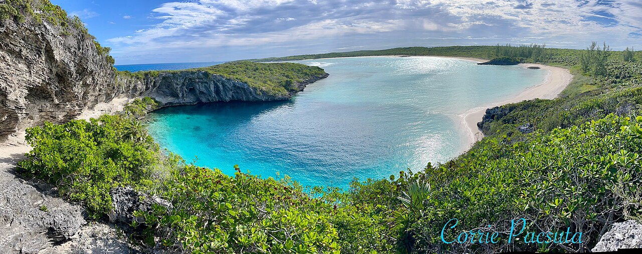
Foto: Oceanwave77 · CC BY-SA 4.0
Estado do acesso não verificado · conforme publicado 2026-10-14 A beach-side blue hole reached on foot by a rocky path; the tourism ministry lists the Long Island Tourist Office as contact. No permit or diving rules are published. As regras de acesso mudam: confirme com o proprietário ou a autoridade responsável antes de viajar.
Documentado Também conhecido como: Deans Blue Hole, Dean's Hole
Extensão mapeada
Não publicado
Profundidade documentada
202 m (663 ft)
Entradas listadas
1
Visibilidade
10–50 m

Not a linear cave; the published dimensions are the surface opening (about 45 x 55 m) and the chamber (at least 100 m across). The tourism ministry and the Grand Bahama Museum give 663 ft (about 202 m); Vertical Blue gives 203 m.

A coastal blue hole near Clarence Town on Long Island, about 200 m deep, that opens below a narrow neck into a cavern at least 100 m across. It is best known as the venue of the Vertical Blue freediving competition.

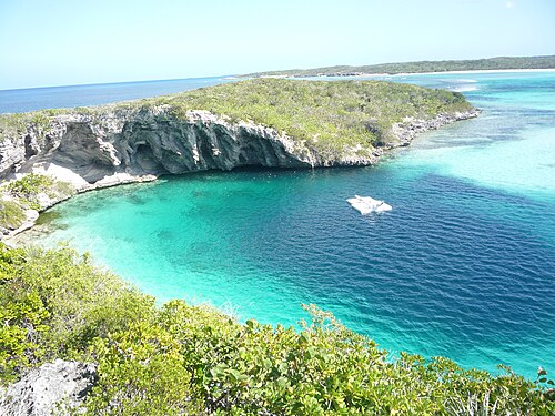
Dean's Blue Hole sits in a sheltered bay next to a beach on Long Island, ringed on three sides by rock walls. At the surface it measures roughly 45 by 55 m, narrows to a series of ledges at 10 to 15 m, and then opens into a huge chamber that the freediving organiser Vertical Blue describes as at least 100 m in diameter.

With a depth usually given as about 202-203 m, it is among the deepest known blue holes; the Grand Bahama Museum and Vertical Blue call it the second deepest blue hole in the world, while the Bahamas tourism ministry says third deepest. How it formed is still debated, since it is much deeper than most Caribbean blue holes.

The site is used mainly for freediving and snorkelling. It hosts the annual Vertical Blue freediving competition, and the water is sheltered from swell and current. No cave penetration route or land-manager diving rules are published.

Geologia

Vertical Blue notes that the origin of the hole is unresolved; one hypothesis is that a much deeper cave migrated upward as its ceiling collapsed over time.

Condições

Vertical Blue describes no current or waves inside the hole and visibility of roughly 10 to 50 m. Tarpon, turtles and reef fish visit the entrance area.

Faixas típicas de fontes publicadas, não as condições atuais.

Entradas e pontos de mergulho

One open entrance from a public beach and lagoon.
Dean's Blue HoleDean's Blue Hole Satélite: NASA Blue Marble

Para orientação, não para navegação. Pontos vazados marcam posições aproximadas.

Fontes: [1] The Islands of The Bahamas (Bahamas Ministry of Tourism) ↗[2] Vertical Blue ↗[3] Grand Bahama Museum ↗[4] GeoNames ↗ · verificado 2026-10-14
Cada informação desta página, com sua fonte (7)
InformaçãoStatusFonte
Dean's Blue Hole is about 663 ft (202 m) deep.Vertical Blue gives 203 m. Ranking conflicts: Vertical Blue and the Grand Bahama Museum say second deepest; the tourism ministry says third. Reportado [1] [3] [2]
The hole measures about 45 x 55 m at the surface, narrows to about 25 x 35 m with ledges at 10-15 m, then opens into a cavern at least 100 m in diameter.Freediving organiser's description. Reportado [2]
Visibility is about 10 to 50 m.Freediving organiser's figure; typical, not current. Reportado [2]
The annual Vertical Blue freediving competition is held at the hole. Verificado [1] [2]
Visitors reach the hole by a rocky path from the beach; contact is the Long Island Tourist Office.No permit or diving rules listed. Verificado [1]
The formation of the hole is not fully understood; one hypothesis is upward migration of a deeper cave by roof collapse. Reportado [2]
Area coordinates are those of Clarence Town in the GeoNames gazetteer; the Grand Bahama Museum places the hole in Clarence Town.Settlement-level; the hole lies close to the town. Reportado [4] [3]

Verificado: declarado por uma fonte oficial ou primária que consultamos. Relatado: proveniente apenas de uma fonte secundária. Fontes divergem: a nota apresenta as duas versões. Pode estar desatualizado: a fonte mais recente que encontramos é antiga.

Escrito com nossas próprias palavras a partir das fontes acima. Reportar uma correção

Austrália, Nova Zelândia e Ásia Oriental

Cairns & the Ribbon ReefsNingaloo ReefCoral Sea & Osprey ReefOkinawa & the Kerama IslandsPoor Knights IslandsTownsville & the YongalaGreen IslandIzu Peninsula

Caribe e Atlântico Ocidental

BonaireCozumelRiviera Maya & the CenotesBelize Barrier ReefGrand CaymanIsla Mujeres & CancúnRoatánTiger Beach & Grand Bahama

Europa, Atlântico & Mediterrâneo

Malta & GozoSilfra & IcelandThe AzoresCanary IslandsLarnaca & the ZenobiaScapa FlowArctic NorwayMadeira

Oceano Índico e África Oriental

North & South Malé AtollsAri AtollBaa Atoll & Hanifaru BayAliwal Shoal & UmkomaasMafia IslandMauritiusSeychellesSodwana Bay

Ilhas do Pacífico & Micronésia

PalauChuuk (Truk) LagoonFakaravaKona, HawaiʻiRangiroaTaveuni & Rainbow ReefBeqa Lagoon & Pacific HarbourEspiritu Santo

Mar Vermelho & Médio Oriente

Sharm El Sheikh & Ras MohammedBrothers, Daedalus & St John'sDahabHurghada & El GounaMarsa Alam & the Deep SouthAqabaDaymaniyat IslandsMusandam Peninsula

Sudeste Asiático e Triângulo de Coral

Bali & Nusa PenidaKomodoRaja AmpatSipadan & MabulAnilaoCoronKoh TaoLembeh Strait

As Américas e o Pacífico Oriental

Galápagos IslandsCocos IslandFlorida KeysSea of Cortez & Cabo PulmoSocorro & the RevillagigedosBritish ColumbiaCalifornia Channel IslandsCosta Rica Pacific Coast